

Infrared Satellite Image Loop
Infrared Image Loop
FL and East GOM
Western GOM
West Atlantic
Florida
Posted on 08/28/2008 8:25:49 AM PDT by NautiNurse
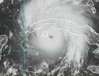
The 2008 peak of hurricane season is ramping up with Gustav and Hanna. The two storms pose threats to the U.S. At least 22 deaths in Hispanola are attributed to Gustav to date, and a Hurricane Warning is in effect for Jamaica. Tropical Storm Hanna has formed in the Atlantic.
| Gustav |
Hanna |
|
|
|
|
| Visible Satellite Image Loop Infrared Satellite Image Loop |
Visible Image Loop Infrared Image Loop |
|
| WV Satellite Image Loop |
WV Image Loop |
|
| Public Advisory |
Public Advisory |
|
| Discussion |
Discussion |
|
| Buoy Data: Western Caribbean FL and East GOM Western GOM |
East Caribbean West Atlantic Florida |
| Category | Wind Speed | Barometric Pressure | Storm Surge | Damage Potential |
|---|---|---|---|---|
| Tropical Depression |
< 39 mph < 34 kts |
Minimal | ||
| Tropical Storm |
39 - 73 mph 34 - 63 kts |
Minimal | ||
| Hurricane 1 (Weak) |
74 - 95 mph 64 - 82 kts |
28.94" or more 980.02 mb or more |
4.0' - 5.0' 1.2 m - 1.5 m |
Minimal damage to vegetation |
| Hurricane 2 (Moderate) |
96 - 110 mph 83 - 95 kts |
28.50" - 28.93" 965.12 mb - 979.68 mb |
6.0' - 8.0' 1.8 m - 2.4 m |
Moderate damage to houses |
| Hurricane 3 (Strong) |
111 - 130 mph 96 - 112 kts |
27.91" - 28.49" 945.14 mb - 964.78 mb |
9.0' - 12.0' 2.7 m - 3.7 m |
Extensive damage to small buildings |
| Hurricane 4 (Very strong) |
131 - 155 mph 113 - 135 kts |
27.17" - 27.90" 920.08 mb - 944.80 mb |
13.0' - 18.0' 3.9 m - 5.5 m |
Extreme structural damage |
| Hurricane 5 (Devastating) |
Greater than 155 mph Greater than 135 kts |
Less than 27.17" Less than 920.08 mb |
Greater than 18.0' Greater than 5.5m |
Catastrophic building failures possible |
wow, now 141kt flight level.
Chocolate Mayor to have presser momentarily.
This will be one of the most political hurricanes ever.
The politicians will be tripping over each other to use this hurricane to promote themselves or their party.
Ugh.
My prayers to all those in the path of this hurricane.
Map of projected target area.
Just saw this on another forum...
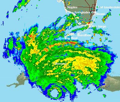
HURRICANE GUSTAV TROPICAL CYCLONE UPDATE
NWS TPC/NATIONAL HURRICANE CENTER MIAMI FL AL072008
120 PM EDT SAT AUG 30 2008
DATA FROM AN AIR FORCE RECONNAISSANCE AIRCRAFT INDICATE THAT
GUSTAV HAS CONTINUED TO STRENGTHEN AND NOW HAS MAXIMUM WINDS
NEAR 145 MPH...230 KM/HR WITH HIGHER GUSTS. THIS MAKES GUSTAV AN
EXTREMELY DANGEROUS CATEGORY FOUR HURRICANE ON THE SAFFIR-SIMPSON
HURRICANE SCALE. A SPECIAL ADVISORY WILL BE ISSUED AT ABOUT 200 PM
EDT TO MODIFY THE INITIAL AND FORECAST INTENSITIES. THE SPECIAL
PUBLIC ADVISORY WILL TAKE THE PLACE OF THE INTERMEDIATE PUBLIC
ADVISORY PREVIOUSLY SCHEDULED FOR THAT TIME.
$$
FORECASTER KNABB
Could you update the headline to Category 4?
Sorry, didn’t mean to step on your toes here. I just asked the admin to update the title to Cat 4. I hope that is acceptable to you.
not surprising..

On/Off Hurricane List Mash Here-->
Per 527......
NO!
I did the same. Thanks.
....... Prayers for those in the path.........
Chocolate Mayor presser ongoing at this time. Discussing curfews, etc.
http://www.wwltv.com/video/?nvid=57429&live=yes
Thanks for the ping and all of your hard work on the hurricane threads. Prayers for all of you in Gustav’s path.
I woke up with a headache this morning, usually means a change in weather. It’ supposed to be windy too, gusts up to 30, and we’re on the Atlantic coast of FL!
susei
Header updated. 145 mph? Yeesh.
Not good. Model runs at 2PM EDT correct? Say hello to $5/gal gas. Fill those tanks up folks!!!
Disclaimer: Opinions posted on Free Republic are those of the individual posters and do not necessarily represent the opinion of Free Republic or its management. All materials posted herein are protected by copyright law and the exemption for fair use of copyrighted works.