Skip to comments.
The Polar Vortex: I'm Mad as Hell, and I'm Not Going to Take It Any More
Penn St ^
| January 24, 2014
Posted on 01/24/2014 6:23:20 PM PST by NYer
I thought that my anger over the media's misuse of the term, polar vortex, during the first week of January (2014) had subsided until I heard references this week to a "piece of the polar vortex breaking away" and bringing the current siege of cold weather to the eastern half of the contiguous states. In the words of the late actor, Peter Finch, from his Oscar-winning performance in the film, Network, "I'm mad as hell, and I'm not going to take it any more" (YouTube clip of his acclaimed rant).
What is the polar vortex? For the record, the polar vortex is a broad, cyclonic circulation in the stratosphere that develops in the winter hemisphere over high latitudes...I place the emphasis on stratosphere (at altitudes roughly near 20 kilometers, which is about 12 1/2 miles up). Both hemispheres have a polar vortex, which forms in late fall, reaches peak intensity during mid-winter, and then starts to decay in late winter or early spring. Such a seasonal rhythm suggests that the polar vortex is tied closely to the availability of solar energy. Indeed, stratospheric temperatures plummet dramatically over high latitudes as sunlight disappears from the polar stratosphere (keep in mind that the polar stratosphere gets relatively warm during the summer as ozone absorbs incoming solar energy).
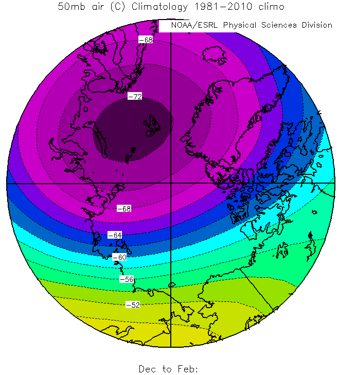
The long-term average 50-mb temperatures (in degrees Celsius) from December to February between latitudes 60 degrees and 90 degrees North. Note the closed contour of minus 72 degrees. This pocket of frigid stratospheric air marks the core of the polar vortex.
Credit: Courtesy of NOAA.
To see my point. check out (above) the long-term average 50-mb temperatures from December to February (meteorological winter), expressed in degrees Celsius. To get your bearings, this map projection is polar stereographic, with the outer circle representing latitude 60 degrees North, while the intersection of the horizontal and vertical lines mark the North Pole. The closed contour indicating minus 72 degrees Celsius indicates the core of the polar vortex. Indeed, compare the image above with the chart below, which shows the long-term average 50-mb heights (expressed in meters) from December to February. I marked the approximate center of the polar vortex with an "L." Granted, it's not a perfect match-up, but the notion that the center of the circumpolar vortex lies in proximity to the coldest stratospheric air is a sound observation. Here's a map of the Arctic, so it looks like the mean position of the wintertime polar vortex lies near the Kara Sea.
At these rarefied altitudes, the average wind (which, by the way is westerly during winter) blows nearly parallel to the height contours, giving you a better sense of the broad, cyclonic circulation of the polar vortex,
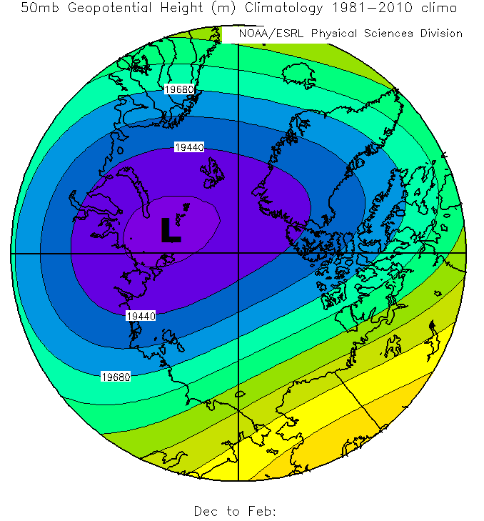
The long-term average 50-mb heights (in meters) from December to February between latitudes 60 degrees and 90 degrees North. The dark "L" marks the approximate center of the polar vortex.
Credit: Courtesy of NOAA.
By summer, robust stratospheric westerlies associated with the wintertime polar vortex, a relatively fast current of air appropriately called the polar night jet, have substantially weakened and reversed direction (robust westerlies at 50 mb during winter transition to weak easterlies in summer). That's because the return of sunlight to the polar stratosphere and its absorption by stratospheric ozone pave the way for the polar vortex to be replaced by a weak area of high pressure. To see what I mean, check out the long-term averages of 50-mb temperatures and 50-mb heights from June to August (meteorological summer).
The polar vortex over the Arctic is not as robust as its Southern Hemisphere counterpart, whose steadfast circulation paves the way for stratospheric temperatures to really plummet and set the stage for stratospheric ozone destruction during the SH's winter (June through August). By contrast, the greater land mass and land-sea contrasts over high latitudes in the Northern Hemisphere generate planetary waves that disrupt the polar vortex over the Arctic. Indeed, it can be highly variable in position and strength, compared to its Southern Hemispheric counterpart, which is less variable, larger, and much colder. So it should not come as great surprise that "pieces" of the more variable polar vortex can indeed "break away" and head southward. But we're talking about the middle and lower stratosphere, certainly not the air at the earth's surface, which is miles and miles away from where the polar vortex resides.
Yet, I heard on television just this morning that a "piece" of the polar vortex is causing the "Arctic blast" that the media loves to promote. Good grief! The person or people who introduced "polar vortex" into the discussion of cold outbreaks this January really don't know what they're talking about.
Now I readily admit that the polar vortex sometimes is "coupled" with the middle and upper troposphere, but using the polar vortex to "explain" Arctic outbreaks at the earth's surface is scientifically questionable, in my opinion, especially if the real goal of the media is good (effective) communication with the general public. In the old days, we old-school forecasters often referred to "cross-polar flow" as a way to explain some Arctic outbreaks (low-level winds advected frigid air southward from polar regions). That wouldn't be good enough in today's world, when it seems like the media looks for single cause and effect. The atmosphere is a lot more complicated than some people realize.
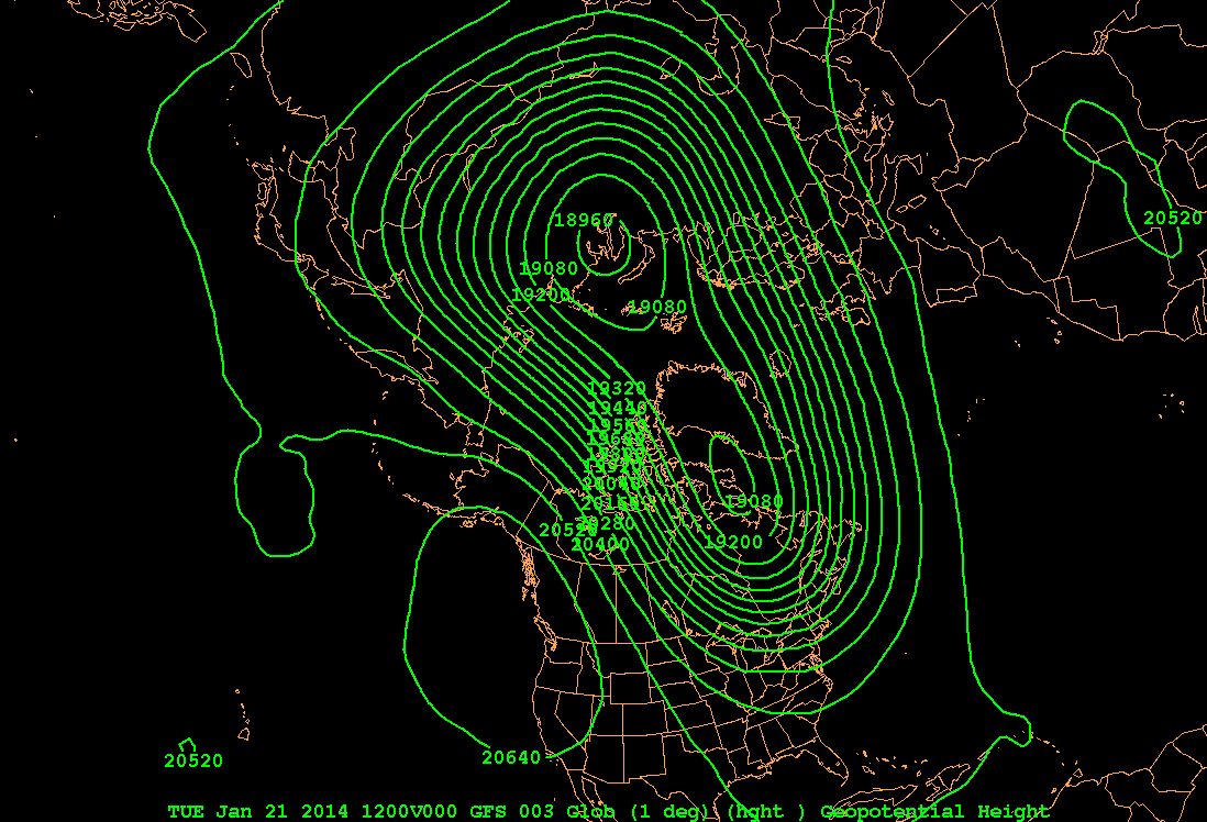
The 12Z GFS-model analysis of 50-mb heights (in meters) on January 21, 2014.
Credit: Courtesy of Penn State.
Above is yesterday morning's (January 21) 12Z GFS model analysis of 50-mb heights (larger image). Essentially, you can see two lobes of the polar vortex (two closed contours of very low 50-mb heights). I assume the 19080-meter closed low north of Hudson Bay is the piece of the polar vortex that the media is currently hyping. At first glance, you might think that the media is correct! But keep in mind that this pattern prevailed near 20 kilometers above the earth's surface!
Okay, lets take a look at 850 mb (about 1.5 kilometers above the ground). Below is yesterday morning's 12Z GFS model analysis of 850-mb heights (larger image). There are several closed lows at 850 mb, including the one east of Hudson Bay.

The 12Z GFS-model analysis of 850-mb heights (in meters) on January 21, 2014.
Credit: Courtesy of Penn State.
Now take a look at the corresponding 12Z GFS model analysis of 850-mb streamlines (below; unannotated version) at 12Z on January 21, 2014. Focus your attention on the closed circulation just east of Hudson Bay (marked by an "L"). For the record, a closed 850-mb low represents a pocket of cold air from the surface to 850 mb. I would argue that the cyclonic circulation around this 850-mb low really wasn't directly impacting the Upper Middle West at this time. Moreover, I would argue that the 850-mb high (marked by an "H") was more directly responsible for advecting Arctic air into the Upper Middle West. Any way you slice it, the couplet of high and low pressure worked in tandem to advect (transport) Arctic air southward into the eastern contiguous states.
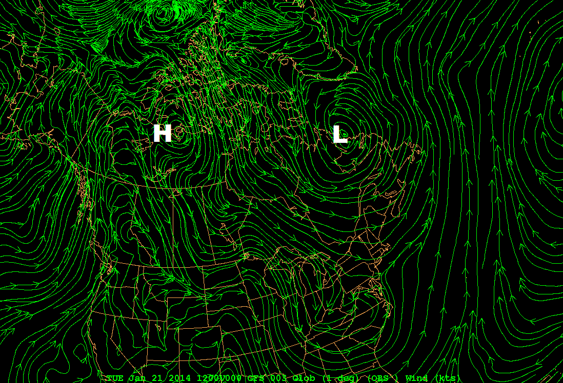
The 12Z GFS-model analysis of 850-mb streamlines on January 21, 2014.
Credit: Courtesy of Penn State.
We can debate whether the closed 850-mb low east of Hudson Bay was directly linked to the piece of polar vortex that supposedly broke away (I seriously doubt it). But that's obfuscating the issue, in my view. No, the real issue I have with the media boils down to their invoking a stratospheric feature to easily and somewhat mysteriously explain away the "Arctic blasts" that occurred this January. No, I prefer a more transparent and honest approach. A tandem of high- and low-pressure systems in the lower troposphere simply advected (transported) Arctic air southward into the eastern contiguous states. If you want to expand this explanation to include "cross-polar flow" (and make old-timers like me happy after you explain what it means), then I'm all in. But please don't invoke a low-pressure system in the stratosphere (the polar vortex) in order to explain away (and apparently hype) patterns of very cold weather when communicating with the general public.
In the end, I have a really tough time making a direct link between the polar vortex and Arctic air masses. The former is a broad, cyclonic circulation at rarefied altitudes that forms in response to the lack of sunlight in the polar stratosphere during the cold season. In stark contrast, the pronounced low-level chill of any Arctic air mass is derived from prolonged contact with the very cold earth's surface (typically at high latitudes). So, in my mind, it's an unscientific leap to make a direct connection between the polar vortex and every Arctic air mass that comes down the pike.
In fairness, there is some research that suggests a long-range (month-to-month and winter-to-winter) connection between the strength of the polar vortex and Arctic air outbreaks in the eastern United States (check out this paper). Using this research, however, as the basis for short- to medium-range forecasts / explanations of Arctic outbreaks is not warranted and scientifically questionable, in my opinion.
I'm still mad as hell, and I'm not going to take it any more.
TOPICS: Outdoors; Science; Weather
KEYWORDS: polarvortex
Navigation: use the links below to view more comments.
first 1-20, 21-33 next last
1
posted on
01/24/2014 6:23:20 PM PST
by
NYer
To: SunkenCiv
2
posted on
01/24/2014 6:23:54 PM PST
by
NYer
("The wise man is the one who can save his soul. - St. Nimatullah Al-Hardini)
To: NYer
They can take global warming and shove it up their polar vortex.
3
posted on
01/24/2014 6:24:58 PM PST
by
tractorman
(I never miss a chance to tweak a liberal.)
To: NYer
To summarize: It’s nippy out there, and the media is hyping it.
4
posted on
01/24/2014 6:25:42 PM PST
by
ClearCase_guy
(Anti-Complacency League! Baby!)
To: NYer
Here's a place to check out winds:
http://earth.nullschool.net/#current/wind/isobaric/1000hPa/orthographic=-81.82,43.40,1609
5
posted on
01/24/2014 6:26:21 PM PST
by
Paladin2
To: ClearCase_guy
"It’s nippy out there"
MUCH, MUCH worse when counting wind chillz.
6
posted on
01/24/2014 6:27:04 PM PST
by
Paladin2
To: NYer
It’s all George Bush’s fault.
7
posted on
01/24/2014 6:28:10 PM PST
by
donhunt
(Certified and proud "Son of a Bitch".)
To: ClearCase_guy
The weather is out of control, and only big, bad government can protect us.
8
posted on
01/24/2014 6:28:47 PM PST
by
Moonman62
(The US has become a government with a country, rather than a country with a government.)
To: NYer
All those green squiggles gave me a headache. Weather is what weather does. Cold is in the US, as warm is in the Philippines.
9
posted on
01/24/2014 6:31:50 PM PST
by
AlexW
To: NYer
“I'm still mad as hell, and I'm not going to take it any more.”
I live in Minnesota, trust me, DO NOT in anger, shake your fists at Mother Nature. Trust me.
So, what's happening in NY regarding Cuomo and de blazio?
10
posted on
01/24/2014 6:32:14 PM PST
by
BarbM
(Portuguese Dog--Kenyan president)
To: donhunt
Grandpappy BUSH did BUSINESS with the VORTEXES!!!
11
posted on
01/24/2014 6:36:12 PM PST
by
MeshugeMikey
("When you meet the unbelievers, strike at their necks..." -- Qur'an 47:4)
To: NYer
Whatever happened to the Alberta Clipper? Seems it has disappeared from cold weather lexicon.
Weather gimmicks are cheesy. I admit I haven't bought into alpha-named winter storms and RealFeelTM trademark temperatures.
12
posted on
01/24/2014 6:48:06 PM PST
by
NautiNurse
(Obama sends U.S. Marines to pick up his dog & basketballs. Benghazi? Nope.)
To: NYer
I’m sure Al Gore can easily refute this, with mathematical formulas that he can just rattle off from the top of his head.
13
posted on
01/24/2014 6:49:26 PM PST
by
Hardastarboard
(The question of our age is whether a majority of Americans can and will vote us all into slavery.)
To: NYer
It’s winter.
It’s cold.
Been that way a long time....
Don’t need a fancy name for it!
14
posted on
01/24/2014 6:55:06 PM PST
by
MountainDad
(Support your local Militia)
To: NYer
Um ... It’s cold. It happens in winter. I’ve seen worse in the last 20 years, and certainly there have been mild winters as well. The author is makes a good argument and is definitely correct about the media. 99.9% of the media are mathematically and scientifically illiterate. Maybe that is being too kind. I doubt there is one journalist in a 1000 that is literate.
15
posted on
01/24/2014 7:05:30 PM PST
by
ConservativeInPA
(We need to fundamentally transform RATs lives for their lies.)
To: NYer
bummer. I misread that as ‘polish vortex’ and was getting all excited about the coming pirogis and vodka.
To: Paladin2
Our local hardware store doesn’t carry thermometers that show the “wind chill” factor. I wonder where the weather forecasters get theirs. (sarc)
17
posted on
01/24/2014 7:25:20 PM PST
by
IIntense
To: IIntense
"I wonder where the weather forecasters get theirs"
A Cracker Jacks Box?
It's a scam of grownup kids who didn't ever want to go to school and get a real education.
18
posted on
01/24/2014 7:27:33 PM PST
by
Paladin2
To: ClearCase_guy
It’s colder than normal in Toronto this year but we’ve had worse. Back in 1997 we had six weeks of daytime highs below -15, this year the cold spells are broken up about once a week where it gets back to normal (-5C), with another break in the forecast with a -3C high tomorrow.
19
posted on
01/24/2014 7:56:36 PM PST
by
Squawk 8888
(I'd give up chocolate but I'm no quitter)
To: IIntense
There actually is a sound formula to it, because heat loss increases with the wind speed. A wind chill of -15 means that your body loses heat at the same rate it would in calm air at -15.
There is an online wind chill calculator here.
BTW in Winnipeg they express the wind chill in minutes- as in the amount of time it takes for frostbite to set in.
20
posted on
01/24/2014 8:02:28 PM PST
by
Squawk 8888
(I'd give up chocolate but I'm no quitter)
Navigation: use the links below to view more comments.
first 1-20, 21-33 next last
Disclaimer:
Opinions posted on Free Republic are those of the individual
posters and do not necessarily represent the opinion of Free Republic or its
management. All materials posted herein are protected by copyright law and the
exemption for fair use of copyrighted works.
FreeRepublic.com is powered by software copyright 2000-2008 John Robinson