
Posted on 08/11/2018 11:53:55 AM PDT by BenLurkin
The scientist mapped the newly discovered canyon on board Irish ship, RV Celtic Explorer, over two weeks.
Led by Dr Aaron Lim of UCC’s School of Biological, Earth and Environmental Sciences (BEES), used the Marine Institute’s Holland 1 Remotely Operated Vehicle (ROV) the team believes the new discovery will aid in understanding more about the transportation of carbon to the deep ocean.
Lim told BreakingNews.ie “This is a vast submarine canyon system, with near-vertical 700m cliff in places and going as deep as 3000m.”
He added, “So far from land, this canyon is a natural laboratory from which we feel the pulse of the changing Atlantic.”
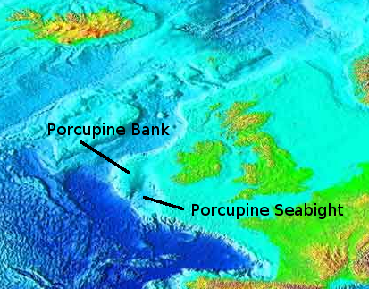
The Porcupine Bank Canyon is full of cold-water corals forming reefs and mounds. These create a rim on the lip of the canyon which is 30 meters tall and 17.3 miles long. The reefs eventually break off and slide down the canyon. They then form an accumulation of coral rubble deeper within the canyon. With the use of equipment, the scientists were able to discover a significant build-up of coral debris.
(Excerpt) Read more at irishcentral.com ...
Did they find any dingleberries down there?


That’s a pretty deep dingle!
Eh? John Dingell was a bigger ‘hole...
AVP
Makes you wonder how many of these obstacles that they run into when they are stringing cables across the ocean floor?

The scientist mapped the newly discovered canyon on board Irish ship...
That is quite a large ship.
My family were berry farmers there for generations.
The berry of the dingle is impossible to eat.
Great graphic. Thanks!
Great graphics. Thank you.
That’s probably the course of the Hudson River during the last major Ice Age when the sea level was about 400’ lower.
Thank you, Trini Lopez.
The Hudson Canyon is a submarine canyon that begins from the shallow outlet of the estuary at the mouth of the Hudson River. It extends out over 400 mi (640 km) seaward across the continental shelf finally connecting to the deep ocean basin at a depth of 3 to 4 km below sea level.
It begins as a natural channel of several kilometers width, starting as a 20-40 m depression at Hudson Channel southward from Ambrose Light, then carving through a deep notch of about 1 km depth in the shelf break, and running down the continental rise.[1]
Tidally associated flows of about 30 cm/s (1 km/h) up and down the deeper parts of the canyon have been recorded. As silt, sand and mud are carried down the Hudson River, they flow into the canyon and out into the deep sea.
The Hudson Canyon proper is located about 100 miles (160 km) east of the mouth of the Hudson River off the New Jersey coast. Its walls rise three-quarters of a mile from the canyon floor making it comparable to the Grand Canyon, whose cliffs are over a mile deep and 270 miles (430 km) long.
It is the largest known ocean canyon off the East Coast of the United States, and one of the largest submarine canyons in the world. The canyon is located near the 100 meter isobath on the continental shelf and is 2,200 m (7,217 ft) deep at the base of the continental slope.
Over an 80 km (50 mi) distance, the average slope of the canyon floor is 1.5°. At this point the canyon is as much as 12 km (7.5 mi) wide (from east rim to west rim) and as much as 1,100 m (3,609 ft) deep from canyon rim to canyon floor across the continental slope. The floor of the canyon is less than 0.5 km (1,640 ft) wide across the upper part of the slope and broadens to about 0.9 km (~3,000 feet) at the base of the slope. [2]
The canyon was last exposed during the last Ice Age, over 10,000 years ago, when the sea level was about 400 feet (120 m) lower and the mouth of the Hudson River was near the edge of the continental shelf, about 100 miles (160 km) east of its present site.
The river discharged sediment that helped carve the canyon aided by underwater avalanches of mud and sand. Recent maps of the canyon reveal tributaries of an extraordinary underwater drainage network that is strikingly similar to terrestrial rivers.
Tidal currents sweep up and down the channel; and on occasion, during big storms, cold ocean water is pushed up the Hudson Canyon to spread out on the shelf. Thus the Hudson Canyon continues to be cut by traveling sediments. [3]
The Hudson Canyon is thought to contain residues of pollution and trash from the days when New York City’s sewage and garbage was dumped directly into the river. If true, many parts of the trench bottom may be covered in sludge. Scientists plan to use new maps of the canyon to track contaminants from six abandoned dump sites off New York Harbor.
“Hudson Canyon” also designates a location marked by a navigational buoy indicating the seaward end of the vessel traffic separation scheme of the Hudson Canyon-Ambrose lanes which lead into and out of New York Harbor for Atlantic shipping.
Disclaimer: Opinions posted on Free Republic are those of the individual posters and do not necessarily represent the opinion of Free Republic or its management. All materials posted herein are protected by copyright law and the exemption for fair use of copyrighted works.