Skip to comments.
New Orleans Levee Failure Assessment
Posted on 09/23/2005 5:02:54 AM PDT by jeffers
This is part four of a five part series examining the Hurricane Katrina levee failures.
Part 1 is a timeline sequence of who reported what flood events, to whom, and when it was reported. It can be found here:
Part I: Hurricane Katrina Flood Report Sequence
Part 2 is a discussion of the levee system's viability, or lack thereof, prior to Hurricane Katrina. It can be found here:
Part II: Pre-Katrina Levee Assessment
Part 3 is a discussion of the overall storm surge sequence, levee failure modes, and causal limitations relating to the 17th Street Canal and London Canal seawall breaches. It can be found here:
Part III: Downtown New Orleans Levee Failures
Part 4, this part, is an assessment of the current functionality and status of the levee systems in St. Bernards and East Orleans Parish.
The original intention for this section was to also include an analysis of the flood sequence in St. Bernard's Parish and East Orleans Parish, and to arrive at some conclusions regarding whether or not the post storm empirical evidence supports the position that significant subsidence had rendered the levee systems fatally flawed before Hurricane Katrina, but that work will have to wait until section five now, because Hurricane Rita is just causing too much trouble and taking up too much time.
I choose not to wait and include everything together because some people are still located in New Orleans and the surrounding areas, and this assessment has yet to reach the general public in its entirety, therefore, additional delay potentially places those persons at risk.
The primary foundation for this assessment rests on an experimental aerial photography/distribution technique developed by the National Oceanographic and Atmospheric Administration (NOAA), and links to this photographic database can be found here:
NOAA Post Katrina Overhead Imagery
The assessment for each of the two areas begins with a status map of that area's levee system, which is followed by a text summary of each notable feature as specified on the map, including a link to the imagery of that feature. The maps are roughly 200kb in size, while each individual sub-image runs between 30 and 160KB.
St. Bernard Parish Levee System Overview Map
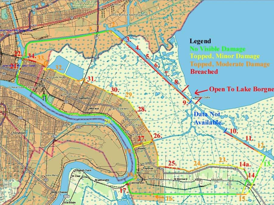
St. Bernards Parish Levee System Post Katrina Damage Assessment
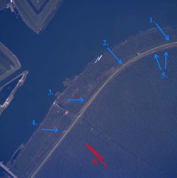
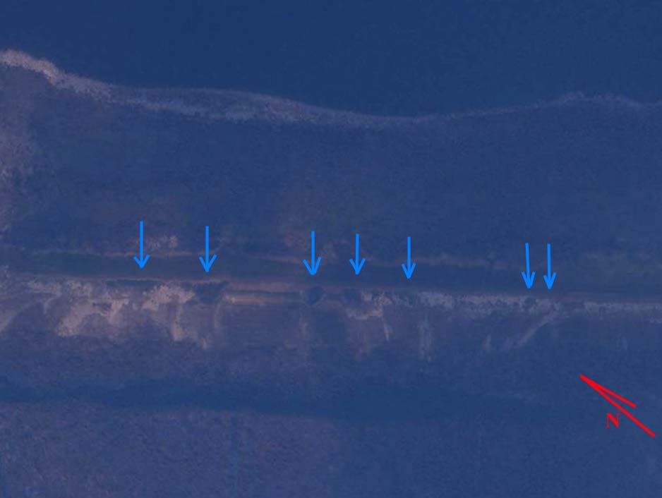
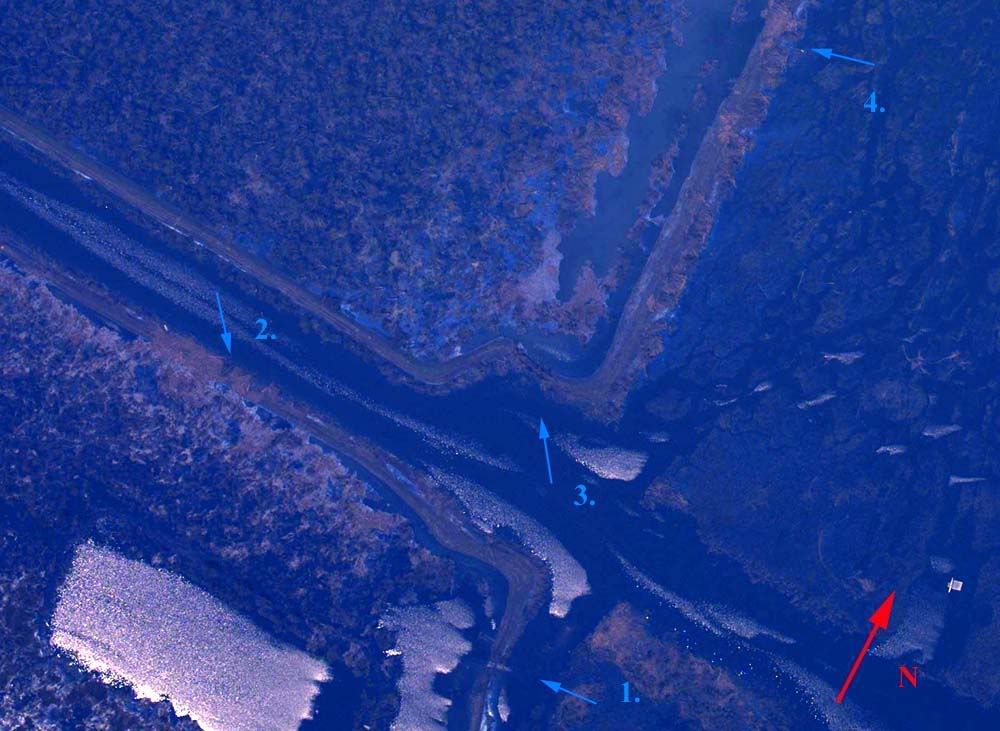
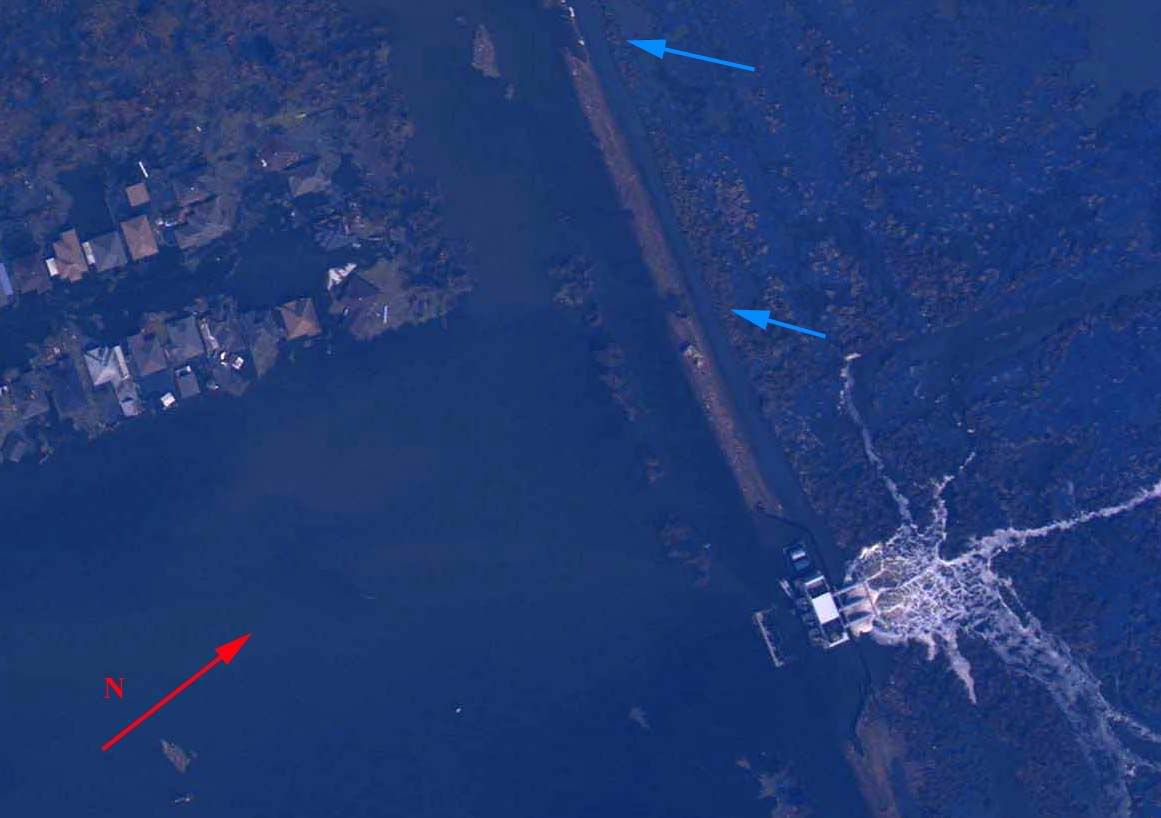
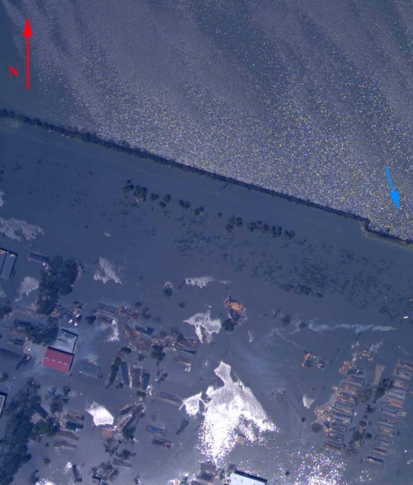
1. Levee/seawall topped by surge at arrow 1, moderate fill displacement, seawall flanked at arrow 2 with moderate fill displacement at arrow 2 and minor fill displacement at arrow 3. The larger of the barges in the image probably unseated the seawall on impact, loosening compacted fill behind the wall. The surge itself, or else disrupted flow over the smaller barges, caused scouring and potholing indicated by the arrows at 4.
Overhead Image
2. Surge topped levee from arrow 1 to 2 along the indicated direction, resulting in minor fill displacement on the inner face, and possible subgrade exposure indicated by arrow 5. A second surge apparantly did not top the levee from the direction of arrows 3 and 4, resulting in minor fill displacement on the levee's outer face. Assuming that the surge directions coincide with tangential winds at the time each event occurred, the surge indicated by arrows 1 and 2 took place shortly after passage of the eye's center, while the event indicated at arrows 3 and 4 occurred later in the storm.
Overhead Image
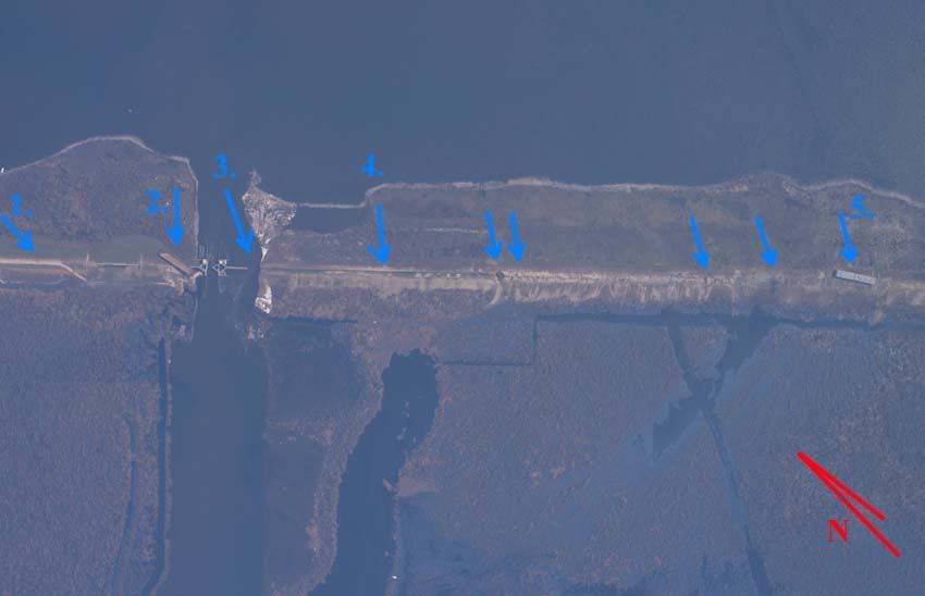
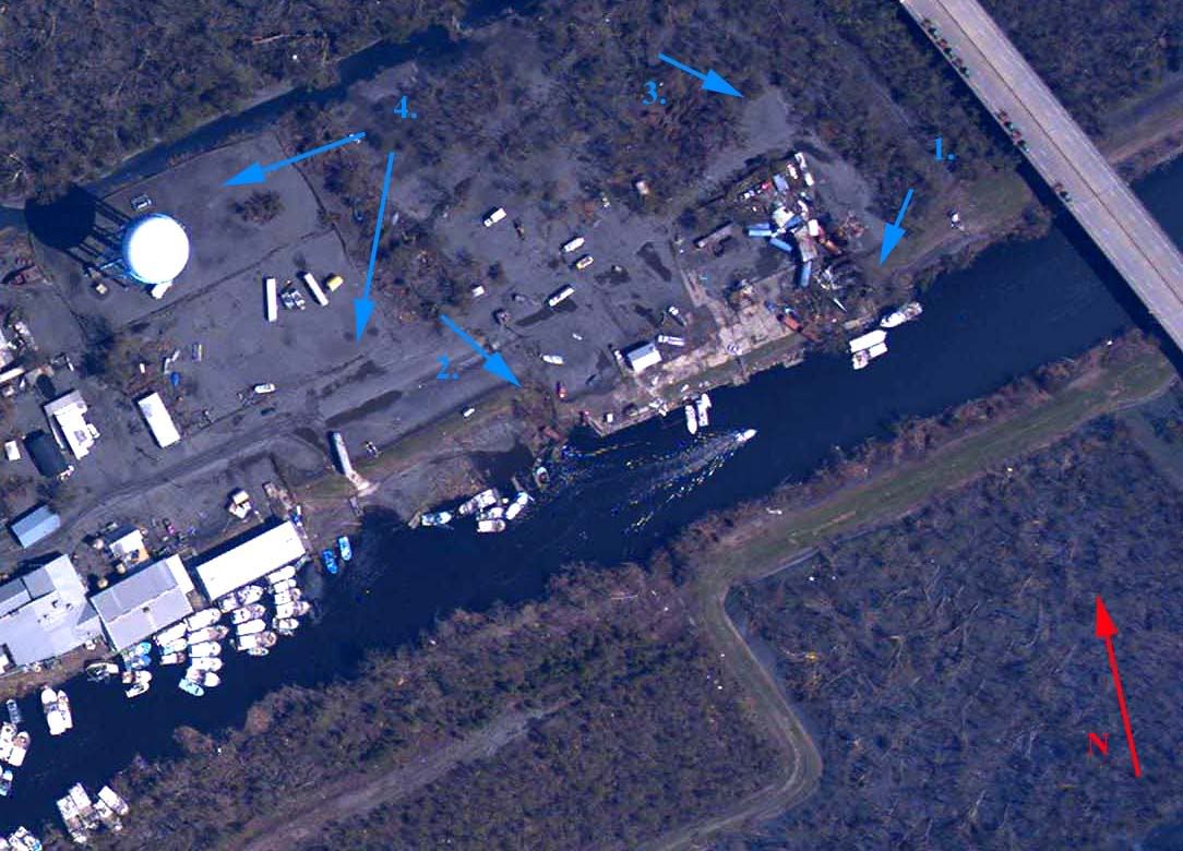
3. Inner face fill displacement indicates direction of surge at arrow 1. Barge atop seawall adjacent to flood control gate indicates surge topped seawall at arrow 2. Surge flanked seawall at arrow three, resulting in significant fill displacement. Easternmost flood control gate most likely inop at time of data capture. Topping at arrow 4 indicates levee cross section mostly intact. Barge at arrow 5 resting nearly at pre-storm levee crest, probably indicating that at least minimal vertical cross section remains intact. Full breaches at the remaining four non-numbered arrows.
Overhead Image
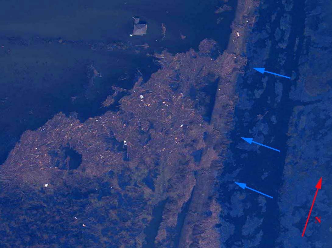
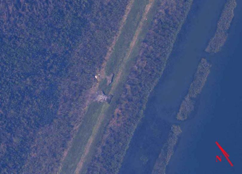
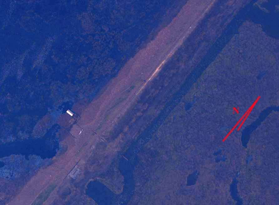
4. Numerous full breaches at arrows. Predominance of northwest trending fill deposition may indicate that these sections failed well prior to passage of the storm's eyewall.
Overhead Image
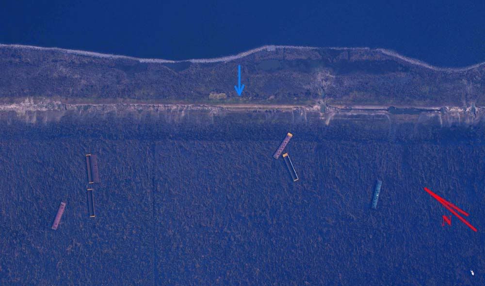
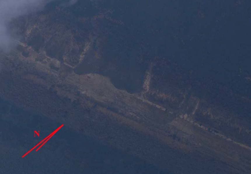
5. Catastrophic breaching. One section of levee possibly undamaged at arrow. Barge lengths estimated at 100 to 150 feet for reference. Fill deposition indicates wind driven surge trending due west at failure.
Overhead Image
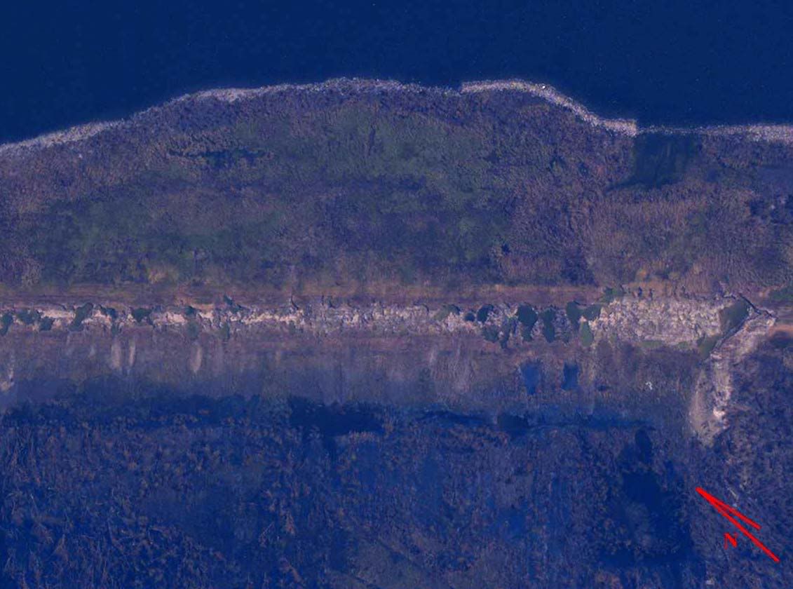
6. Catastrophic breaching. No undamaged sections of levee visible.
Overhead Image
7. Catastrophic breaching. Twin pipelines exposed. Significant fill transport.
Overhead Image
8. Catastrophic breaching. Pipeline exposed. Some visibly undamaged levee sections left standing.
Overhead Image
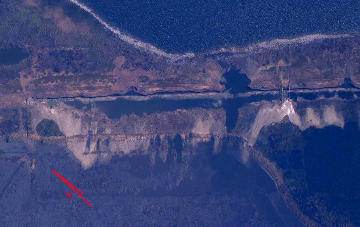
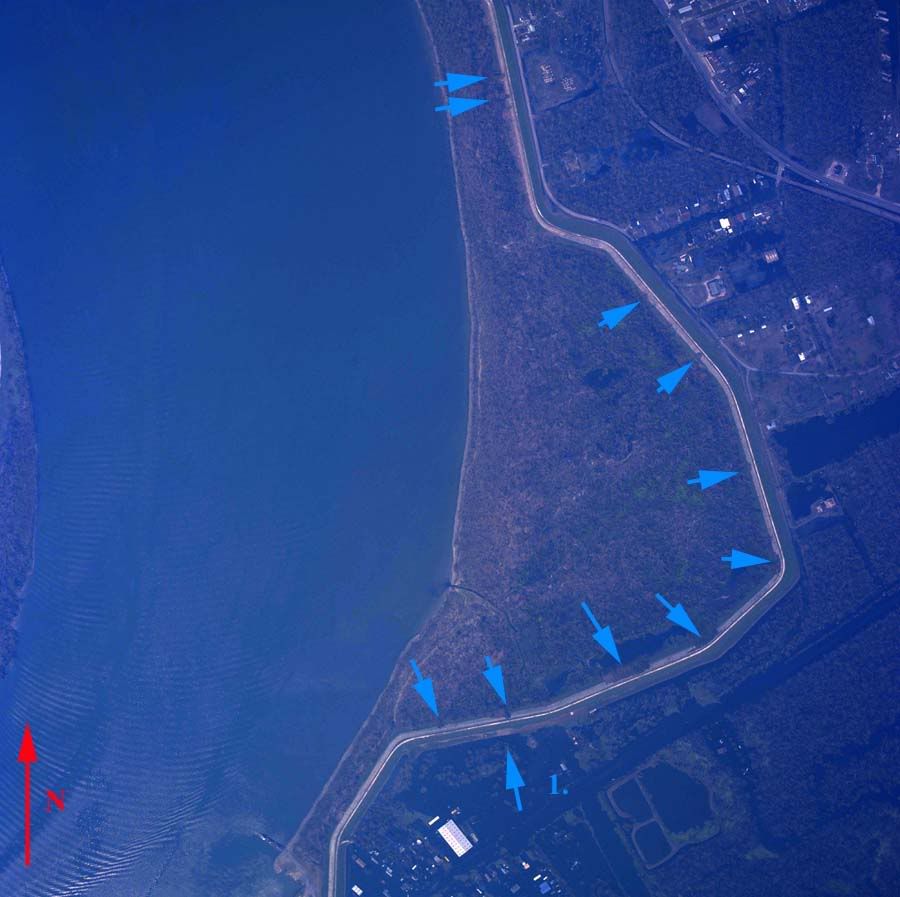
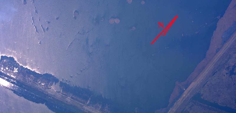
9. Catastrophic breaching, left third of image, balance of levee shows intermittent full breaches. Wetland barrier between Mississippi River Gulf Outlet and Lake Borgne breached for approximately 1 mile, open to the Gulf of Mexico. Island at image's upper right is probably remnants from Martello Castle.
Overhead Image
10. Intermittent breaching/significant scouring and fill transport.
Overhead Image
11. Intermittent breaching/significant scouring and fill transport.
Overhead Image
12. Intermittent breaching/significant scouring and fill transport.
Overhead Image
13. Minor topping and scouring, subfill exposed at arrows.
Overhead Image
14. 200' full breach. Fill transport at arrows 1 and 2 indicates a probable bidirectional flow of water at different times during the flooding. Arrow 3 probably indicates another storm breach.
Overhead Image
14a. Two full breaches, water flowing out of populated area, height differential noted with levee center line at arrows 1, probably sand boils at arrows 2, 3, and 4 indicate probable percolation through levee to downstream face.
Overhead Image
15. Scouring and potholing at arrows. Fill displacement suggests topping occurred from inside to outside.
Overhead Image
16. Topped in direction of arrows. Minor fill transport.
Overhead Image
17. Seawall breach at arrow, may be deliberate opening of flood control structure.
Overhead Image
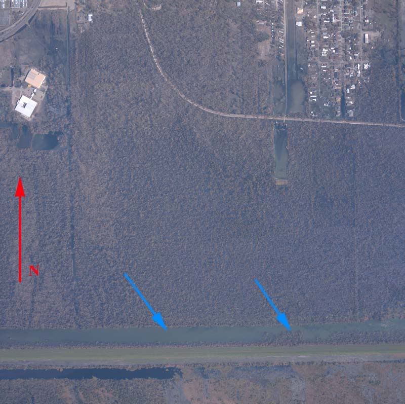
18. ***RIVER LEVEE*** Concrete or riprap facing displaced, numerous locations at arrows. River levee vulnerable to river wave action where facing no longer exists. Minor fill displacement at arrow 1 on inner face.
Overhead Image
19. ***RIVER LEVEE*** Concrete or riprap facing displaced, locations at arrows. River levee vulnerable to river wave action where facing no longer exists. Moderate fill displacement at arrow 1 on outer face.
Overhead Image
20. ***RIVER LEVEE***Concrete or riprap facing displaced, locations at arrows. River levee vulnerable to river wave action where facing no longer exists. Minor fill displacement at arrow 1 on inner face.
Overhead Image
21. 500' seawall breach, probably caused by loose barge, debris logjams at arrows 1 and 2, and the resting location of the barge at arrow 3, indicate the initial surge flow was in through the breach, though later the flow reversed, as shown in the image.
Overhead Image
22. Seawall breach, seawall remnant at arrow 1 indicates initial failure was inward, debris transport at arrows 2 and 3 indicate that Florida Canal breach (between the arrows) was in opposition to the seawall breach at arrow 1, at some point flow reversed direction at arrow 1 and flows out of the breach at the time the photo was taken.
Overhead Image
23. Minor potholing, fill displacement and scouring at arrows.
Overhead Image
24. All visible sections heavily abused. Fill displacement and transport at arrows probably indicates weakening.
Overhead Image
25. Multiple full breaches at arrows, fill transport away from breaches indicates significant flood velocities away from the populated area.
Overhead Image
26. Multiple breaches at arrows, fill transport and scouring at arrows 1, 2, and 3 indicate initial breachs from Violet Canal into populated areas, while cratering at arrow four may be due to wave action or may be due to populated areas overfilling with water topping the levee back out into the marshy areas later.
Overhead Image
27. Breach at arrow 1, probable breach at arrow 2. Debris in breach at arrow 1 indicates significant flow volume and velocity out of populated area, but wetting and scouring at arrows 3 and 4 indicates a counterflow at some point, into the populated area.
Overhead Image
28. Multiple breaches at arrows, debris deposition indicates flow into populated area.
Overhead Image
29. Numerous small pockmarks and fill displacements at arrows.
Overhead Image
30. Breaches at arrows. Minor flanking at both ends of pump station seawall. Fill removal pattern there indicates that flow direction was into the populated area.
Overhead Image
31. Breach at arrow, fill transport out of populated area, smooth and linear breach perimeter and presence of heavy equipment adjacent to breach indicate this is probably a deliberate breach.
Overhead Image
32. Numerous minor and moderate cave-ins and scoured areas on outer face, subfill exposed along inner face, events probably originated from both inside and outside.
Overhead Image
33. Possible breach or damage to flood control structure at arrow 1. Numerous pockmarks, boils and fill displacements at arrows.
Overhead Image
34. Possible subsistence issue, long stretch of levee under or nearly underwater.
Overhead Image
East Orleans Parish Levee Overview Map
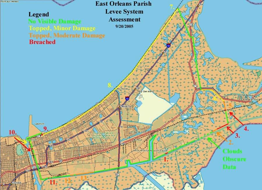
East Orleans Parish Levee System Assessment
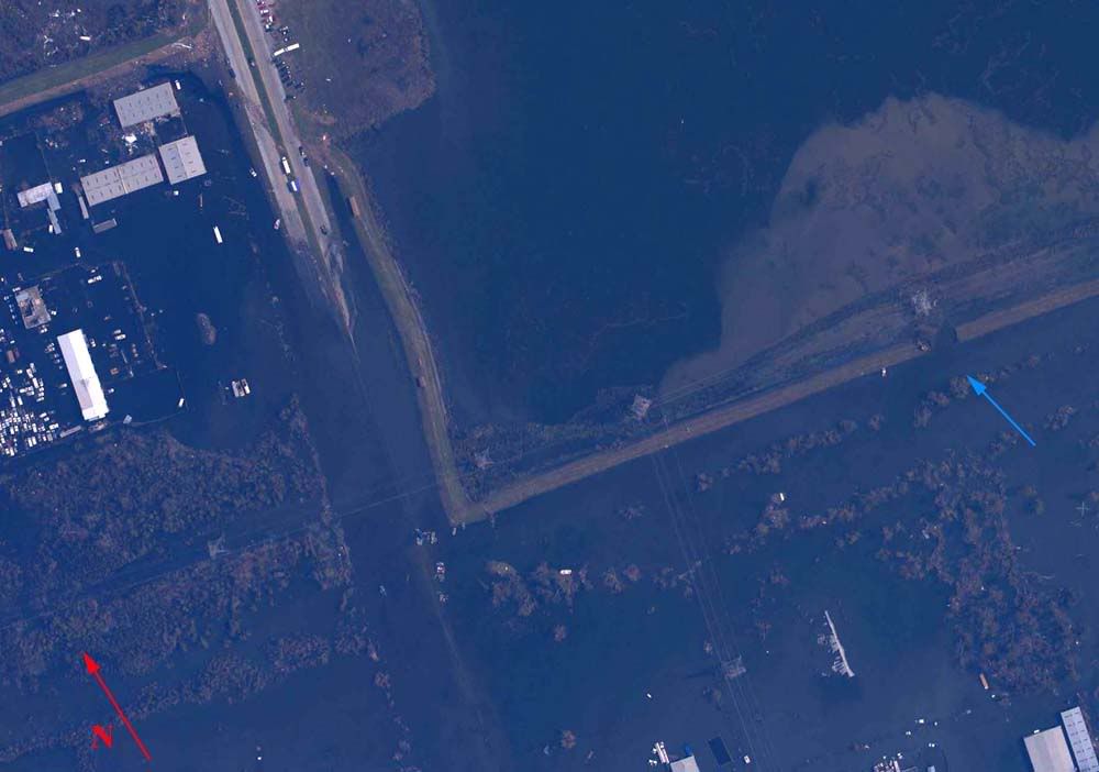
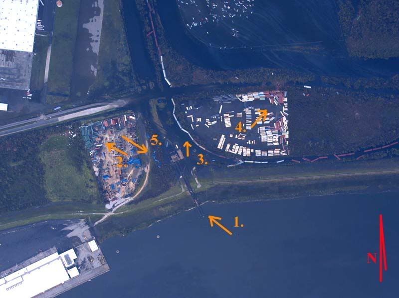
1. Isolated breach and partial collapse, probable cause; topped by rogue wave, secondary source of rural east Orleans flooding.
Overhead Image
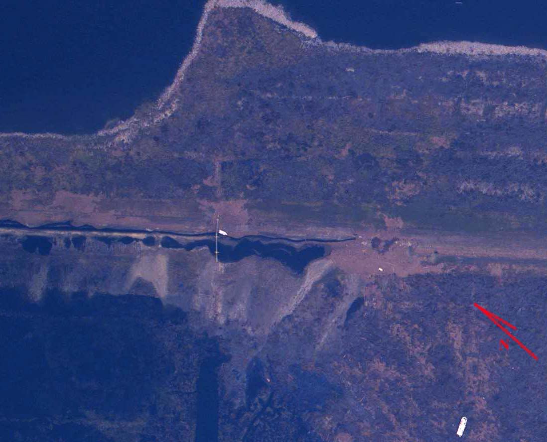
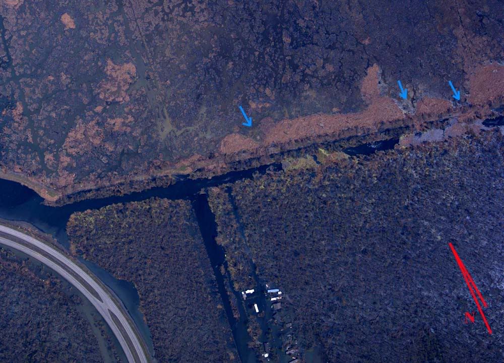
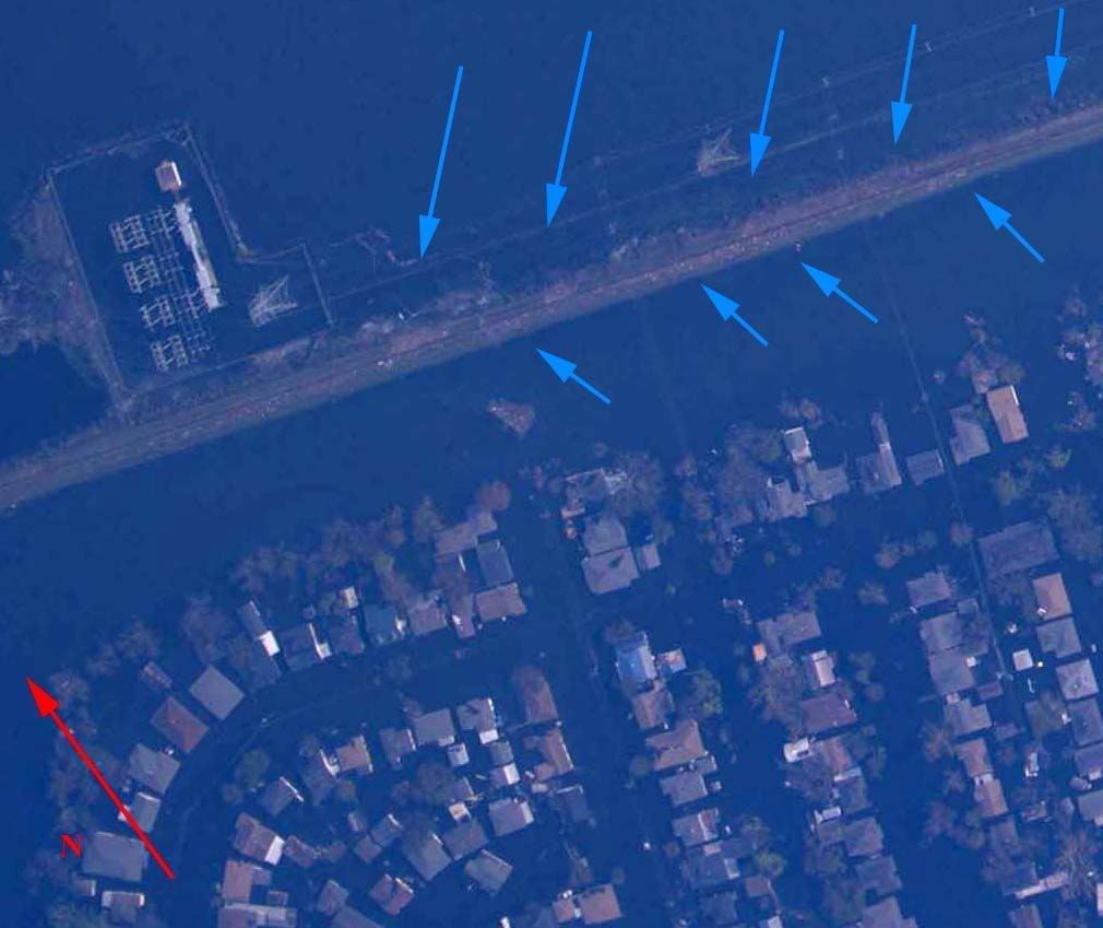
2. Major breach, several areas of significant scouring, probable cause; liquefaction by sustained surge. Major contributing factor to rural east Orleans flooding.
Overhead Image
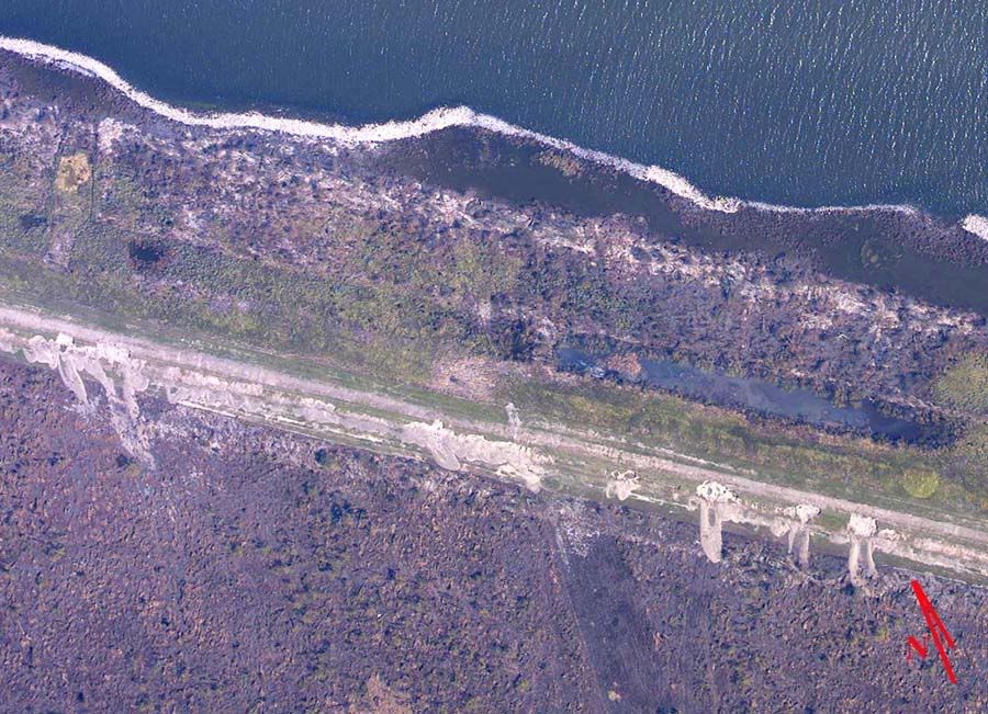
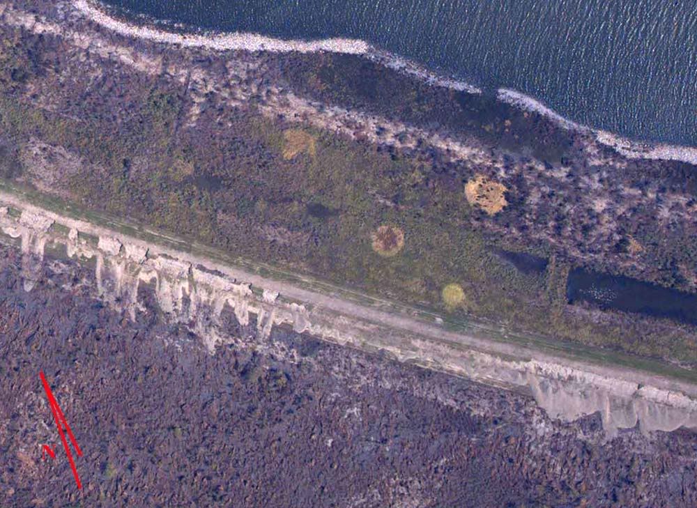
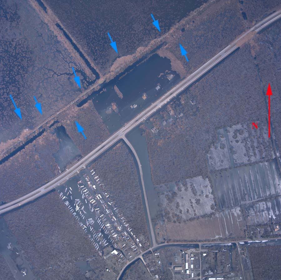
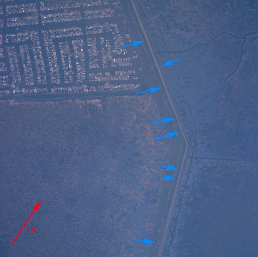
3. Multiple major breaches, topped by sustained surge, numerous full and partial breaches, wide areas of vegetation inside failed section removed by scouring, significant quantities of fill material deposited at considerable distances from point of origin. Major contributing factor to rural east Orleans flooding.
Overhead Image
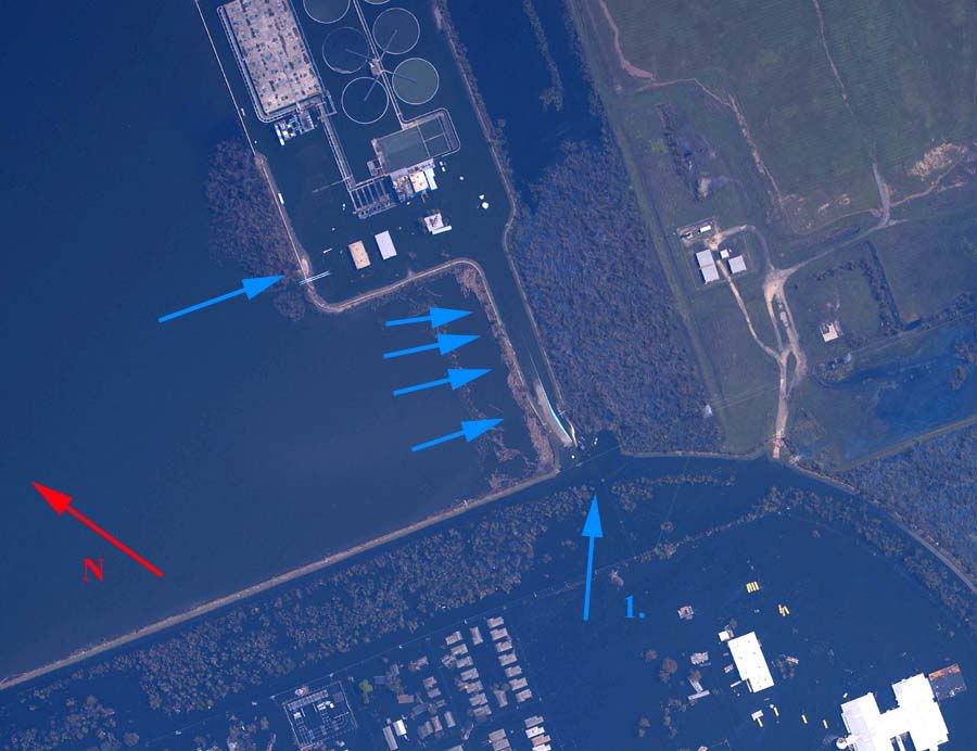
4. Minor breach, flood control gate flanked by sustained surge, moderate amount of non-structural fill removed.
Overhead Image
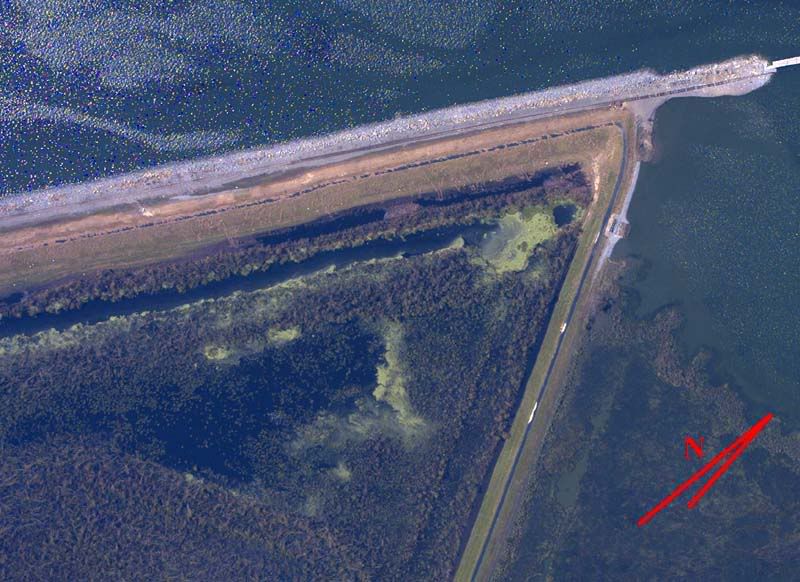
5. Topping by sustained surge, moderate fill removal, some pocking and cratering but no full breaches visible.
Overhead Image
6. Minor Topping. Debris fields indicate considerable topping occurred, but little, if any damage or fill transport is visible.
Overhead Image
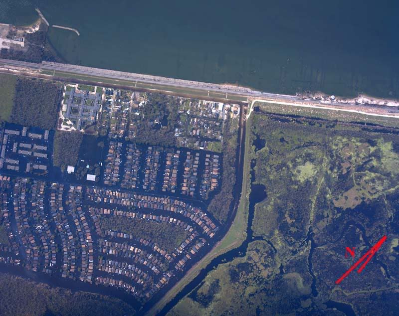
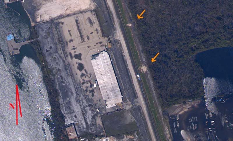
7. Minor topping. Well designed corner withstood peak winds with only minor wave topping on the Lake Pontchartrain section. Negligible fill quantities deposited on inner Lake section face, visible only under magnification. Flooded road atop levee indicates a depression there, not significant damage.
Overhead Image
8. Minor topping. Debris fields indicate frequent wave topping, but no fill appears to have been disturbed, with the possible exception of the inner face, upper left section of image.
Overhead Image
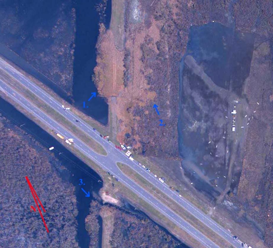
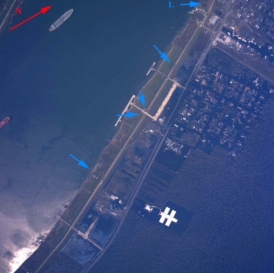
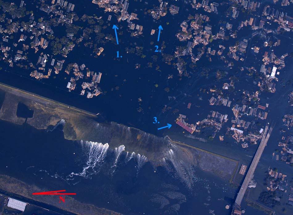
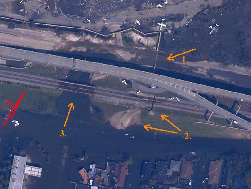
9. Certain small breach, probable major breach, critical components obscured by elevated freeway. If so, this is most likely the primary cause of urbanized east Orleans flooding, with inundation from Lake side wave topping secondary in effect. Sustained Lake surge at arrow 1 probably flanked or topped flood control gates at same location. Some flooding certainly took place as evidenced by displaced fill at arrow 2. Significantly more flooding probably occurred through waterway at arrow 3. Elevated freeway pylons at arrow 4 may have been undermined by scouring.
Overhead Image Zoom Overhead Image
10. Minor breach and moderate scour, probably due to Lake surge channelized between buildings.
Overhead Image
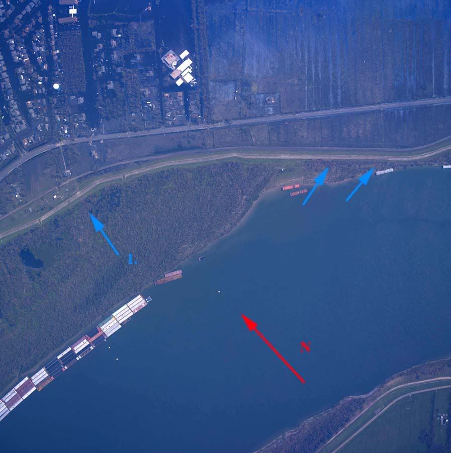
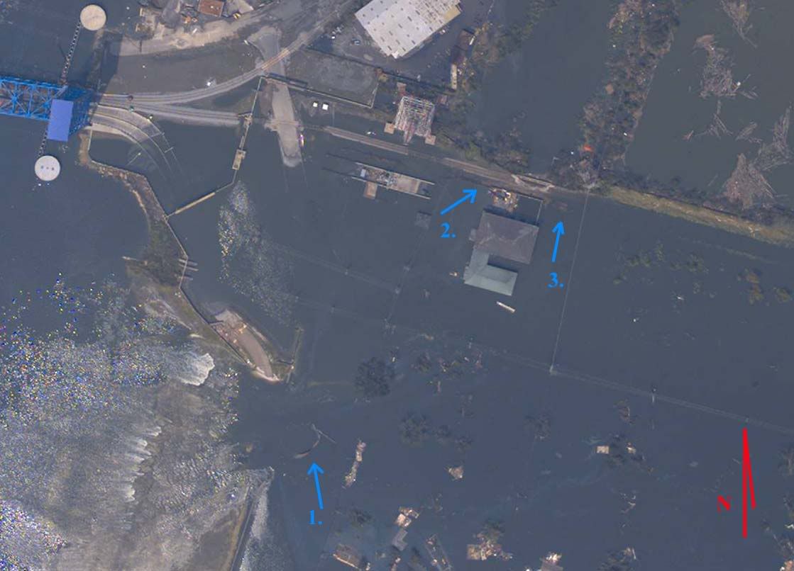
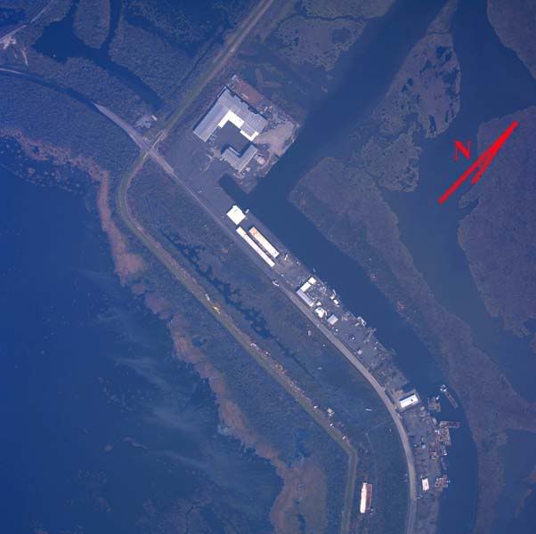
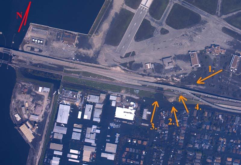
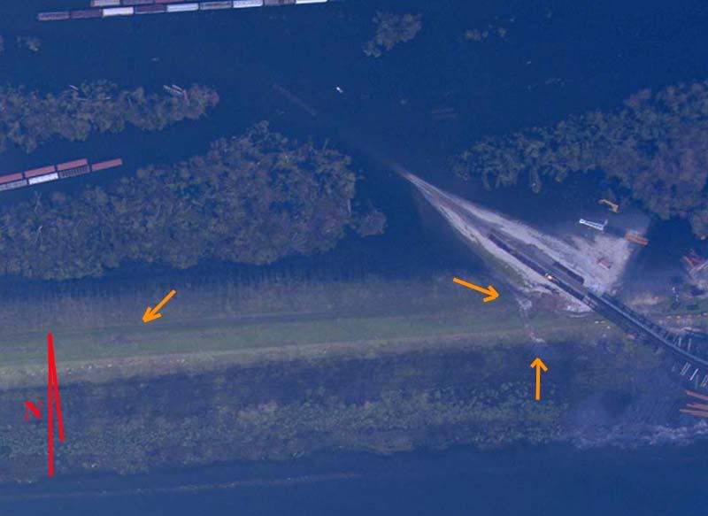
11. Major breach or significant surge/topping. Unclear if arrow 1 denotes a breach but two areas of fill displacement on inner face demonstrate flowing water in this area, as do rail cars pushed from tracks at arrow 3 and displaced shipping containers at arrows 2 and 4. Also interesting is an apparant reversal in surge flow as evidenced by displaced bright blue containers at arrow 5. This later and lesser surge is also evidenced by the oil slicks from parked cars at upper right of the image.
Overhead Image
12. Minor topping/scouring at arrows.
Overhead Image
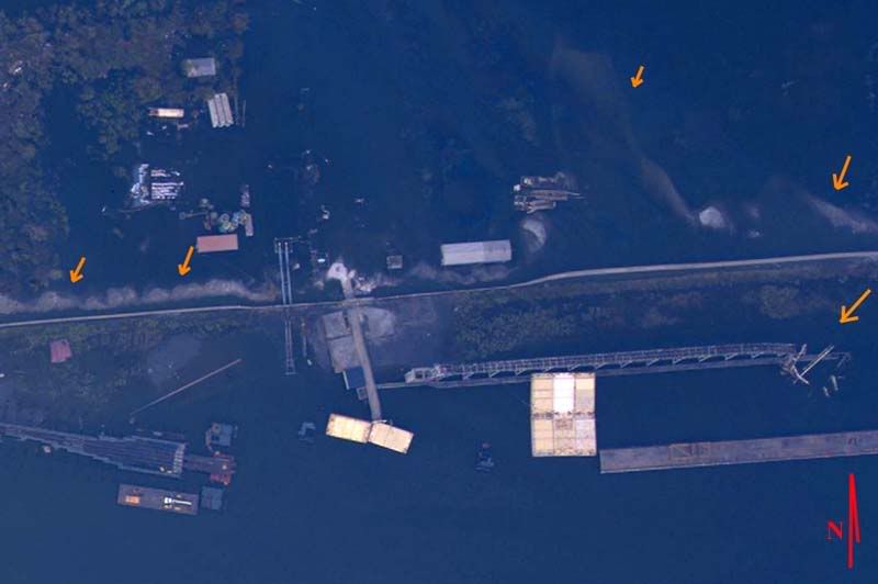
13. Significant fill transport at arrows inside levee indicate a large area of surge topping and direction of travel. Gantry damage at arrow outside wall may indicate either wind direction or a surge reflection from the seawall.
Overhead Image
Even without delving into detailed analysis, certain conclusions are hard to miss.
1. Many or most failed sections were subjected to a storm surge far beyond their original design specifications.
2. Both Parish areas flooded from multiple levee breaches, from different directions, and at different times.
3. Many levee segments failed in multiple directions at different times during the storm's passage.
4. Notably absent are significant failures along the Intercoastal Waterway between the two Parish areas. Funneling did not result in levee failures in this area.
I have some thoughts on these issues already and have a good idea how the flooding sequence took place, but this is a good spot to leave off, if for no other reason than it's time to take a look at Rita and see if she's turned towards Houston since 1 am or not. Feel free to ask questions or raise issues not considered so far.
TOPICS: Business/Economy; Crime/Corruption; Extended News; Front Page News; Government; Miscellaneous; News/Current Events; Politics/Elections; Technical; US: Louisiana; Your Opinion/Questions
KEYWORDS: 229; blanco; canal; canals; corruption; flooding; hurricane; katrina; katrinafailures; landrieu; levee; leveeboard; levees; louisiana; nagin; neworleans; rita
Navigation: use the links below to view more comments.
first previous 1-20, 21-40, 41-60, 61-65 next last
To: jeffers
Ping for later.
Curiosity on how this compares to the LSU(?) reports of no-to-minor overtopping, with low debris rings.
41
posted on
09/23/2005 11:12:18 AM PDT
by
Gondring
(I'll give up my right to die when hell freezes over my dead body!)
To: jeffers
Great assessment from you --as usual. Thanks for the ping.
To: jeffers
Thank you very much.
Really nice work.
bttt.
To: jeffers
Is there a lock on the Industrial Canal between the breach and the Mississippi River?
To: Enchante
Why canals? 1) it is a port. 2) drainage. Need someplace for the pumps to pump to. That is not the problem; the problem is there is no buffer between the canals and the peeps.
To: jeffers
46
posted on
09/23/2005 1:10:36 PM PDT
by
FBD
(make April 15th just another day! www.fairtax.org)
To: Sunnyflorida
To: jeffers
48
posted on
09/23/2005 1:45:11 PM PDT
by
Dog
To: AmericanArchConservative
Awesome, thanks for the ping.
49
posted on
09/23/2005 2:30:23 PM PDT
by
Fred Nerks
(Understand islam understand evil - read THE LIFE OF MUHAMMAD free pdf see link My Page)
To: Cboldt
I work right near the folgers plant. I'm situated between the Chef Hwy and the railroad track in the 14000 block of Chef. The area didn't take any water if you're curious. Apparently the highway and tracks acted as a makeshift levee and kept everything dry in that sliver of land. The area covering Six Flags was still under a lot of water at the beginning of this week.
50
posted on
09/23/2005 6:48:24 PM PDT
by
Bogey78O
(Live from Hurricane Katrina- Western St. Tammany Division)
To: Sunnyflorida
Well the general idea was that if a catastrophic failure occured they might destroy other levees to release the water and save the city. They toyed around with the idea in the past of dynamiting levees on the westbank to save the eastbank. Wouldn't have helped here since the water mainly came from the lake side.
51
posted on
09/23/2005 6:51:30 PM PDT
by
Bogey78O
(Live from Hurricane Katrina- Western St. Tammany Division)
To: jeffers
Thanks for the ping. You've been busy!
52
posted on
09/23/2005 8:47:25 PM PDT
by
nuconvert
(No More Axis of Evil by Christmas ! TLR) [there's a lot of bad people in the pistachio business])
To: Cboldt; Brilliant; Gumdrop; nuconvert; visitor; Barnyard; carola; 1903A3; babble-on; ...
To all:
Thanks for the compliments, my response there is "aw shucks".
:-)
Things are "quiet" right now. Rita is just ashore, the folks who would be giving damage reports are either hiding under furniture, their attics, or esle don't have communications with the outside world, the hardcore who stayed up for landfall have gone to bed, and there's an information vacuum of sorts here at 445 am, Saturday morning, so I thought I'd take the time and respond to some comments.
jmaroneps37: The new media is indeed the wave of the future. It's an elephant in the living room. I have to admit that the empirical evidence fails to support the satellite elevation data in one respect, the levee along the south side of the ICW (north of St. Bernard's Parish, didn't fail or even suffer major damage. That's due to the funneling effect that didn't happen to the degree expected. Pretty sure I have this figured out, but want to check a few things before casting an opinion. That'll come out with the full analysis, I suspect. If I'm right, in that one way, New Orleans did indeed "dodge a bullet".
Coop,
You want more data, hmmm? Been thinking about adding Plaquemines Parish to the mix. The thing there is that we all know what levees failed (all of them) why they failed (they were underwater, at sea, in a Cat 4 storm), and there's not many questions currently at hand regarding that area. Worth the effort or not, what do you all think?
AdmSmith,
ltns...too long...you caught Mr. O or Mr. AZ yet?
frankjr,
The new NOAA tool is a good one. Haven't had time to scope it all out, but from very initial first impressions, it looks like a combination of GPS, an aerial photo rig, and a software interface that facilitates posting the data online. Just fly around, do a data dump after landing, and the webpage posts itself. Very nice.
I suspect the Corps of Engineers will do a more thorough inspection. Too hard to tell from the air if a wet spot is a surface puddle or else surface evidence of percolation that has penetrated the core block, indicating the levee is soon to fail there. In any event, they have some digging to do.
Not sure about the rebuilding effort. On the one hand, I can see where they'd want to hurry. Storm season isn't over yet. On the other, not even sure they can do much before storm season gives way to winter, so there's an argument for doing it right. I don't think any strictly earthen levee shy of the Rocky Mountain Front Range will withstand a Cat 5, so right off the bat, the design specs have to address a major question, "how much storm do you want to negate?"
Then you either look at earthen with either a clay or concrete core block, and a concrete or riprap facing to negate wave damage, or a fully integrates concrete seawall with a concrete or steel curtain wall underneath to prevent scouring and percolation from toppling your new wall. Several questions pop up here. Will the marsh carry that kind of weight? Is anyone deep pocketed enough to fund that kind of effort? Can we wait long enough to do that kind of job without risking subjecting the city to another surge?
syriacus,
I was stunned by the damage extent too.What you can't see on the low res jpegs I posted is that that kind of damage extends for miles.On the high-res NOAA images, you can zoom in practically forever and in many cases, it's hard to tell where the levees actually were.
conservatism_IS_compassion,
In many cases the key is to make a concious decision to ignore the now and force yourself to look at the future implications. It helps to know when to effect this and when to come back to the current though, especially when driving :-).
Cboldt,
It angers me that the east Orleans and St. Bernard Parishes are being ignored in the media. It's almost like no real people ever lived there. There's collectively more than 100k people that called those areas home, and the press seems to think they were just wiped off the map and therefore aren't worthy of attention.
backhoe,
I considered licensing the overview to the media, but from my message to Cboldt, you can see what I think of them. I'll do this, for non-commercial purposes, consider this thread public domain. For the media, send commercial inquiries to jeff4303ATyahooDOTcom. Bring gold, in quantity. Probably more than you have. :-)
Sunnyflorida,
That's a good point. Engineers never like single layered defenses. There is opportunity here, to do the thing right this time. Even balancing the need for immediate protection. We could just dump fill in for now and build new levees in a second wall inside, then firm up the old ones. There are things to think about though. One, the effect of wetlands that impede storm surge. Two, An overall plan that addresses many concerns raised over the years, saltwater encroachment, silt containment by the current system, etc. We've learned a lot since the levees were improved since Betsy, maybe now we can put it to use. I think it's past time for Mr. GO to go.
M. Espinola,
Thirty feet is good for height, but what's going to carry that kind of weight? Put in a fancy piling system to distribute the weight and you increase the weight. There is no bedrock there, it's all marsh, down to the center of the earth's core. (joke, but not by much) I'm thinking the only weay to get that high would be a very thick levee, with internal deformation resistance, so that the entire structure would have to sink as a mass, without the taller portions sinking faster and disturbing integrity of the whole. Significant cost there. Also 30 feet may not be high enough. A different storm can and will funnel large areas of surge into a smaller area of ICW. Over at St. Louis Bay, I think we're going to see minimum surge at 33 to 35 feet, and I've seen anecdotal reports that some cases exceeded 40. Where do you stop? Katrina was only the third largest storm of record. Not dismissing your opinion, just the opposite. Where would YOU draw the line?
Enchante,
The whole canal thing bugs me too. It just seems wrong. But on reflection, even a swamp gets rained on, and by natural law, every drop of new water has to go somewhere.
AmericanArchConservative,
You're too kind. The real engineers will do this right, in-depth, redundant confirmation, big supercomps to put it all together. The question is, will we listen to them this time around?
Gondring,
I haven't read the LSU reports firsthand so I'm not sure of their claims. Along Lake P the topping was minor. You have to zoom in hard to even see the minor sandwashes on the levees' inner faces. Elsewhere, such a claim would be highly ignorant. Section 34 of the St. B's levee system (as on the map) is underwater now. Others were listed as "severely abused" and that's being kind. Dirt piles don't retain much integrity when repeatedly submerged. They tend to spread out into a wide fan. That's what the closeups show in many cases.
Sunnyflorida,
Yes to the lock as you found out. In fact the CoE was upgrading that lock shortly before the storm and the 9th ward residents halted the project with a corut order, citing noise as the objection. Not the travesty it seems. I don't think the Corps really supports the lock anyway. It is used to allow ships from Mr Go (Mississippi River Gulf Outlet) to access the river and for river ships to access the Industrial Canal slips. Mr. Go needs to go, everyone knows it, and when the dust settles, the advocates of closing it will come back on it's few supporters with a vengeance. I suspect some of them have already consulted bankruptcy attorneys.
nuconvert,
I'm always busy. Idle hands....
to all,
Heading back to Rita live now, how long that ties me up depends on what we learn today. Rescue always takes precedence over post mortem analysis, but this isn't going to die. I need to go back over the photos, many more of them this time around, to solidify my earlier impressions of flood and failure sequencing, then I'll post the results here.
The major question still remains.
Did the supposedly Cat-3 levees sink before Katrina ever existed?
Even if I'm not here for a few days, I haven't and won't forget about that.
See you when I see you, now back to the storm.
53
posted on
09/24/2005 3:43:08 AM PDT
by
jeffers
To: jeffers
Sorry I'm late with comments, I'm up getting ready for work and read this over:
Great Work, Jeffers.Good read, great info, stay safe!
54
posted on
09/24/2005 4:05:24 AM PDT
by
Former Dodger
( "Insanity: Doing the same thing over and over again and expecting different results." --Einstein)
To: jeffers
What, no barges with dynamite?
55
posted on
09/24/2005 4:08:41 AM PDT
by
toddlintown
(Your papers please.)
To: jeffers
Good work, jeffers.
There is also a fine article in Friday WSJ front section regarding estuaries that ties back to flood control. Perhaps someone has posted that.
56
posted on
09/24/2005 4:53:56 AM PDT
by
bwteim
(Begin With The End In Mind)
To: jeffers
Awesome work, nicely done.
Any thoughts on how high the MS River is about to get due to Rita, and what that will do to the river levees?
57
posted on
09/24/2005 5:06:26 AM PDT
by
FreedomPoster
(Guns themselves are fairly robust; their chief enemies are rust and politicians) (NRA)
To: jeffers
58
posted on
09/24/2005 5:37:22 AM PDT
by
Ellesu
(www.thedeadpelican.com)
To: jeffers
Again, excellent work. Fox News needs to hire you. They have been extremely dopey on hurricane coverage. That guy Bill Hammer is so clueless. I'm glad they pulled Trace what's his name off. Well after we all knew better (last week) he had the "ENTIRE city of New Orleans 12-22 feet below sea level." I hate to say it but they simply get the facts wrong. Too bad; I like the fair and balanced politics and they do not blame Bush for everything but they are pathetic when it comes to a story on geography or physical sciences.
On the industrial canal. From NOAA charts of the area it looks like there is quite a bit of port and commercial activity along the industrial canal. I have not cruised it personally and the NOAA charts do not get updated very frequently, but if they close off MR GO AND the lock it would make these port areas pretty much land locked with access only by coming all the way around from the Lake.
If they opened up the lock the water in the canal would be much higher. This points to the really funky thing about the NOLA area: the River is highest point. It is just a wild concept to think that if you stand on the bank of the River and walk away you walk down hill.
To: jeffers; All
Very good job !!! I just showed one of the maps to my wife whose cousin lives in Chalmette(sp). She does internet work and was VERY impressed with the job you did of compiling all of this info , (and I am impressed also, but then again I am continually amazed by the resourcefulness and intellegence of so many freepers here on FR !!)
Thanks for the post!!......and.....
BTTT !!
60
posted on
09/24/2005 7:03:18 AM PDT
by
musicman
Navigation: use the links below to view more comments.
first previous 1-20, 21-40, 41-60, 61-65 next last
Disclaimer:
Opinions posted on Free Republic are those of the individual
posters and do not necessarily represent the opinion of Free Republic or its
management. All materials posted herein are protected by copyright law and the
exemption for fair use of copyrighted works.
FreeRepublic.com is powered by software copyright 2000-2008 John Robinson