Note tropical storm warning at north end of the Lesser Antilles and tropical storm watch at Puerto Rico.
Posted on 08/01/2006 2:44:58 AM PDT by Clive
000
WTNT33 KNHC 010840
TCPAT3
BULLETIN
TROPICAL STORM CHRIS ADVISORY NUMBER 2
NWS TPC/NATIONAL HURRICANE CENTER MIAMI FL AL032006
500 AM AST TUE AUG 01 2006
...TROPICAL DEPRESSION STRENGTHENS INTO TROPICAL STORM CHRIS... ...NEW TROPICAL STORM WARNINGS AND WATCHES ISSUED...
AT 5 AM AST...0900 UTC...THE RESPECTIVE GOVERNMENTS HAVE ISSUED A TROPICAL STORM WARNING FOR THE ISLANDS OF ANTIGUA...BARBUDA... ANGUILLA...ST. KITTS... NEVIS...SABA...ST. EUSTATIUS... ST. BARTHELEMY...ST. MARTIN...AND ST. MAARTEN. A TROPICAL STORM WARNING MEANS THAT TROPICAL STORM CONDITIONS ARE EXPECTED WITHIN THE WARNING AREA WITHIN THE NEXT 12 TO 24 HOURS.
AT 5 AM AST...A TROPICAL STORM WATCH HAS BEEN ISSUED FOR PUERTO RICO AND THE U.S. VIRGIN ISLANDS...AND FOR THE BRITISH VIRGIN ISLANDS. A TROPICAL STORM WATCH MEANS THAT TROPICAL STORM CONDITIONS ARE POSSIBLE WITHIN THE WATCH AREA...GENERALLY WITHIN 36 HOURS.
FOR STORM INFORMATION SPECIFIC TO YOUR AREA...INCLUDING POSSIBLE INLAND WATCHES AND WARNINGS...PLEASE MONITOR PRODUCTS ISSUED BY YOUR LOCAL WEATHER OFFICE.
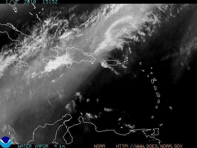
AT 500 AM AST...0900Z...THE CENTER OF TROPICAL STORM CHRIS WAS LOCATED NEAR LATITUDE 16.6 NORTH...LONGITUDE 59.2 WEST OR ABOUT 175 MILES...280 KM...EAST OF ANTIGUA.
CHRIS IS MOVING TOWARD THE WEST-NORTHWEST NEAR 9 MPH...15 KM/HR... AND THIS GENERAL HEADING IS EXPECTED TO CONTINUE OVER THE NEXT 24 HOURS. ON THE FORECAST TRACK...CHRIS IS EXPECTED TO MOVE OVER OR NEAR THE NORTHERNMOST LEEWARD ISLANDS LATER TONIGHT OR EARLY WEDNESDAY MORNING.
MAXIMUM SUSTAINED WINDS ARE NEAR 40 MPH...65 KM/HR...WITH HIGHER GUSTS. SOME STRENGTHENING IS FORECAST DURING THE NEXT 24 HOURS. AN AIR FORCE RESERVE RECONNAISSANCE AIRCRAFT IS SCHEDULED TO INVESTIGATE THE TROPICAL STORM THIS AFTERNOON TO PROVIDE A MORE ACCURATE ESTIMATE OF THE STRENGTH AND LOCATION OF CHRIS.
TROPICAL STORM FORCE WINDS EXTEND OUTWARD UP TO 35 MILES...55 KM FROM THE CENTER.
THE ESTIMATED MINIMUM CENTRAL PRESSURE IS 1009 MB...29.80 INCHES.
RAINFALL AMOUNTS OF 3 TO 5 INCHES...WITH ISOLATED HIGHER AMOUNTS TO NEAR 8 INCHES...ARE POSSIBLE OVER THE NORTHERN LEEWARD ISLANDS IN ASSOCIATION WITH CHRIS.
REPEATING THE 500 AM AST POSITION...16.6 N...59.2 W. MOVEMENT TOWARD...WEST-NORTHWEST NEAR 9 MPH. MAXIMUM SUSTAINED WINDS...40 MPH. MINIMUM CENTRAL PRESSURE...1009 MB.
AN INTERMEDIATE ADVISORY WILL BE ISSUED BY THE NATIONAL HURRICANE CENTER AT 800 AM AST FOLLOWED BY THE NEXT COMPLETE ADVISORY AT 1100 AM AST.
$$ FORECASTER STEWART
Note tropical storm warning at north end of the Lesser Antilles and tropical storm watch at Puerto Rico.

Somehow I screwed up the image link in my reply 2.
I know allot of CHris' and trust no harm will be done by this one.
Just not right.
This image and the image in FlJoePa's reply 3 will periodically update automatically.
12 days and counting till the Kentucky and South Carolina Coleman's head out for their Walt Disney World vacation. This time of year was not my 1st, 2nd, or 3rd choice.
Thanks for the thread. Will keep a watchful eye to the skies.
I hope ..... as I watch from Key West
.
I'll bet gas prices jump a nickel just on the news that a storm has been named.
Atlantic storms' absence causes midwest heat waves to intensify and lengthen..I blame ___________ fill in the blank.
I'm with you on that Elle Bee. No storms in the Keys this year!!!!!!!! I'm still cleaning the yard after last years mess.
Scott on Sugarloaf Key
and this year I self insured
I couldn't see throwing away 18K on windstorm insurance and then have to overcome a 25K deductible
I'll just throw the money into hardening the house each year ... and say a prayer
.
Best post in accuracy.
Prayers up for not on hard wind so you can get that yard clean.
I am still waiting for a roof replacement from a rare PNW blower last year.
Ins. paid now trying to get the contracted roofer to do his repair.
Oh. Well no money to the job untill they get busy.
>>I blame ___________ fill in the blank.
Al Gore, because he invented Global Warming.

My feeling now is that Chris should remain a significant tropical cyclone throughout the 120-h forecast period...which is in contrast to all of the global models and the GFDL model.
Forget all these dang compooters, I got me a FEELIN' !!!
Too early to tell but, this one could be headed for the Gulf. Weather guys in Austin already mentioning the possibility. We could really use the rain.
Aug 1st, right on schedule. It seems every year right at this time, the storms come out from hiding. Karl Rove must have his weather machine back from its spring overhaul.
Disclaimer: Opinions posted on Free Republic are those of the individual posters and do not necessarily represent the opinion of Free Republic or its management. All materials posted herein are protected by copyright law and the exemption for fair use of copyrighted works.