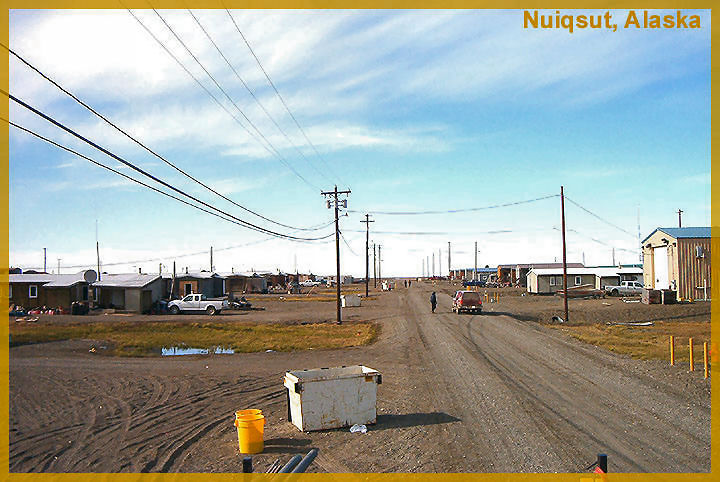
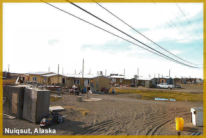
Nuiqsut was an abandoned village before a group from Barrow decided to bring their families to live there in the 1970's.
Posted on 06/02/2011 7:35:20 AM PDT by thackney
A proposed bridge and pipeline in the remote reaches of Alaska are highlighting the obstacles facing the U.S. in its push to produce oil in ecologically sensitive regions.
The infrastructure would allow ConocoPhillips, the U.S.'s third-largest energy company by market value, to begin developing the first commercial oil well in Alaska's National Petroleum Reserve since it was opened to drilling in 1998. The project, first proposed in 2005, has taken on new urgency with President Barack Obama's May pledge to conduct more frequent lease sales in the 23-million-acre reserve.
But Conoco's project has been stymied in part by the U.S. Army Corps of Engineers, which cited environmental worries in refusing to grant the company a permit to build a bridge, a gravel road and a pipeline over a waterway to its drill site. The project traverses the Colville River Delta, a mosaic of arctic lakes and channels in the far eastern reaches of Alaska's North Slope.
The project has put two federal agencies at odds. The Environmental Protection Agency has maintained that a roadless alternative, which would route the pipeline under the Nigliq Channel and use an airstrip instead of a road and bridge, would be less damaging to the reserve's environment. The Interior Department backs Conoco's proposal as environmentally preferable.
...
Conoco has proposed building a 1,400-foot bridge over the Nigliq, and a six-mile gravel road that would allow it to haul materials and workers to and from the drill site. A pipeline would ship oil from the wells—as much as 18,000 barrels a day—over the channel to the company's processing facilities. The project has received the endorsement of Alaskan landowners that would be affected and the nearby Village of Nuiqsut.
(Excerpt) Read more at online.wsj.com ...
There are several fields past this first one that have been drilled and flow tested. Building the bridge and pipeline for the first one opens up access to several more fields.
Initial Project Map
http://www.conocophillipsalaska.com/permits/CD5%20Permit%20apps%202008/CD5%20ACCESS%20ROAD_map.pdf
Future expansion fields Map
http://www.conocophillipsalaska.com/permits/CD5%20Permit%20apps%202008/CD5-CD6-CD7-FIORD%20WEST_1-9-09.pdf
Link to location:
http://maps.google.com/?ie=UTF8&ll=70.332378,-151.133766&spn=0.090475,0.527&t=h&z=12
The damn state is more than twice the size of Texas. The idea that it should remain pristine or that we’re going to upset the balance of nature is absurd.
If it isn’t one thing, it’s another.
Deliberate “decision to make a “non-decision” ....
Real intent is to NOT develop the oil at all.
Or, phrased differently, the fundamental intent is for each and every part of the Washington enviro-friendly bureaucracies to be able to defend themselves as “the most strict” in defending “environmentalism” over ANY oil development anywhere.
Except offshore Brazil.
Offshore Mexico.
Offshore Cuba.
Anywhere in Russia.
Any Arabic or Islamic country.
More than a million acres of wildlife reserves and parks are not enough for some crazy people.
Sigh. Our government is killing us slowly.
Wow! What forbidding terrain to try to build surface access through: the glaciated delta of a river that flows northward into the Arctic Ocean!
BTW, what is that river named?
I've been "exploring" the area on Google Earth. No wonder the folks in the Village of Nuiqsut like the proposal: by building (or having built) a half-dozen miles of road to connect to the project road NE of Oil Lake, they would have (all-weather?) road access to "the outside world"...
The "airstrip" option makes no sense to me. I know what massive equipment and supplies are required for oil exploration and production. And it would do nothing for the Village of Nuiqsut -- because they already have their own airstrip -- right?
BTW, I grew up in "oil-patch housing" (in Texas). The (present-day) Village of Nuiqsut looks awfully familiar... Is that where the oilfield workers live/stay?
Answered my own question: "Colville River Delta"...
RTFA, TXnMA! '-{
All supplies are either flown in, or supplied by an Ice Road and Bridge built each winter.
Alpine was built around 2000, it was to prove that they could operate in such a roadless environment.
The danger of not connecting the well pads to West to the main base camp is weather blowing in before everyone can get out. They also use some Hovercraft in this part of the world but not very useful in heavy winds.
I have stayed at Alpine several times in the past decade. I have ridden across the Colville River Ice Bridge before.
Forgot to mention, some villagers from Nuiqsut work at Alpine. They want the bridge and road so they can live at home rather than the base camp.
Also if the bridge/road was built, they could provide some other basic services to the area.
I went to the first public hearing in Anchorage for the consideration of the development. They brought a village elder down to Anchorage to speak at the public hearing. His ONLY concern was that if built, it was built with the road and bridge to bring more jobs to the village and a way for them to sleep at home with their families.
Was the original site of Nuiqsut slightly to the east, near the boat ramp? (Or -- is that another GE placemark error?) The Village of Nuiqsut is quite a development in itself. Are those street lights -- or just power poles -- that I see (the shadows of)?
Looks like oil income has made a huge difference to the Village of Nuiqsut.
BTW, do the ice roads leave any sort of imprint at all after thaw? (Apparently not, because [what I interpret as a) "'thumper' seismo grid" on the snow/ice north of Alpine is not visible at all when the ground is ice-free...)
FWIW, I see the rig was still up at the CD4 pad in June 07.
Nuiqsut was an abandoned village before a group from Barrow decided to bring their families to live there in the 1970's.
~~~~~~~~
In the "Humble Camp" where I lived, we had free gas (without added mercaptans for safety).
All lots had a gas meter, and Dad planted his WWII "Victory Garden" on a neighboring vacant lot. Each fall, he would flatten the end of a piece of pipe into a "flare", hook the pipe to the gas with a garden hose -- and burn off the entire garden.
He always did it at night, and drew a big crowd of spectators. Our garden was the only one free of grubworms and "nutgrass"...
~~~~~~~~
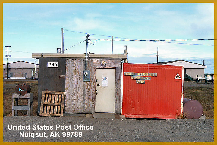
Fwiw, I note the Nuiqsut Post Office has electricity -- but a kerosene space heater... '-)
That has got to be one of the US's most isolated settlements!
Thanks Robert A. Cook, PE.
“Zero doesn’t work for us” update ping.
Disclaimer: Opinions posted on Free Republic are those of the individual posters and do not necessarily represent the opinion of Free Republic or its management. All materials posted herein are protected by copyright law and the exemption for fair use of copyrighted works.