

Posted on 03/01/2012 5:44:38 PM PST by TSgt
The setup and aftermath on Friday for the Ohio and Tennessee valleys could be similar to the weather pattern during and following the 1974 Super Outbreak.
Spanning April 3-4, 1974, a swarm of tornadoes tore through areas from Illinois and southern Michigan to northern Alabama and Georgia.
The outbreak produced 148 confirmed tornadoes, six of which were F-5 intensity. The most powerful of these storms slammed into Xenia, Ohio.
Every weather pattern no matter how similar always has its differences, and this outbreak will have its own characteristics.
However, according to Severe Weather Expert Henry Margusity, "In the case of the end of this week and back in early April of 1974, it appears strong upper-level winds and cool air approaching from the west could hit a zone of advancing warm, moist air in just the right manner to produce monsters of thunderstorms."
This is not to say communities that were hit by the tornadoes in 1974 will be hit again, as the atmosphere is much more random than this.
"There will be a strengthening storm system tracking to the northeast from the southern Plains to the Great Lakes," Margusity said.
Former West Lafayette, Ind., resident Senior Meteorologist Jim Andrews recalls that outbreak.
"Having one of the super cell thunderstorms pass right over my town was the scariest moment of my life," Andrews said.
Fortunately, Andrews' town was spared any major damage.
This outbreak is not likely to extend as far north into the Great Lakes region as that of 1974.
We pray the storms are far less intense and hope they avoid places where people live.
We do urge that people take this threat seriously, as there is a risk of violent storms sweeping through population centers and rural communities.
Also similar to 1974, a sweep of cold air in the wake of the tornado outbreak will yield areas of snow.
Snow blanketed Xenia only hours after the devastating tornado swept through in early April of 1974.
Most of any snow that falls this weekend immediately in the wake of severe weather will tend to be focused near the Great Lakes into the central Appalachians.
The pattern could add to the misery of cleanup operations from the midweek event and, woefully, from Friday into Saturday.
It is possible some snow showers dip as far south and west as portions of the Ohio and Tennessee valleys by early Monday.
According to Severe Weather Expert Dan Kottlowski, "At least the weather pattern in the wake of the storms Friday into Saturday will be much less volatile in these areas and others for many days."
Drier, more stable air will settle over the region through much of next week.
We were in California at the time and couldn’t reach any of my family. It was a scary time. My sister watched the KY Fair and Exposition Center blow up as the tornado ripped through it. We returned a month later. It looked like God had reached down and pulled these huge trees up like weeds. I think I will spend tomorrow cleaning the basement.
Check your link. It is horrific.
Been a card-carrying Skywarn member since 1998.
Apologies, freepers.
That link should have been:
http://abclocal.go.com/wls/feature?section=weather&id=6665563
(Test your links, posters!)
HAHAHA.
That was yesterday’s caption thread and I’d left the link in the clipboard buffer. YI-effing-IKES!
Sorry, my friend.
Boy wasn’t that an unpleasant surprise!
This is a Bad One.Here in South Alabama the sky was strange,,,,This is a bad storm,take care.
I would also advise you to tune-in CH.4 if your in the area as they update live on-air faster than any other station.
(I am not affiliated with WSMV btw) :^)
I DO NOT recommend full screen mode! Ha!
I lived in Xenia during those tornado’s of 1974. That was a really bad day for tornado’s. If you watch the Whether Channel on April 3rd they will always say something about those storms.
I would be my basement ready if I lived in central and southern Kentucky, tho. :)
Bump!
Yeah, me too. SW Michigan. . . how 'bout you?
The time of the Nashville flood, we were traveling through Tennessee on our way to a family wedding. We visited family in Jackson, TN overnight, having no idea what was coming except that it was going to rain. The weather radio made so much noise all night that we eventually unplugged it. There was really nowhere to go in an emergency, so we just tried to get a little sleep. By the next morning, we were barely able to get out of Jackson. We got out on the last open highway out of the county at around 8am. It was surreal driving through miles and miles of flooded fields, with our car making its way down a skinny ribbon of interstate which sometimes narrowed to less than a lane. Hard to believe it was almost 2 years ago.
Having grown up in the Midwest, I have a healthy respect for violent weather. Hubby and kids haven't lived it and think I'm a little nuts. Oh well. Maybe they're right!
heads up ping...!!!
I was in college in Muncie, Indiana that day and drove home to the east side of Indianapolis through some areas that looked like war zones.
Up really early this a.m. We are “smack-dab” in the white bulls-eye today. Anxiety level=infinite! Pray for safety!

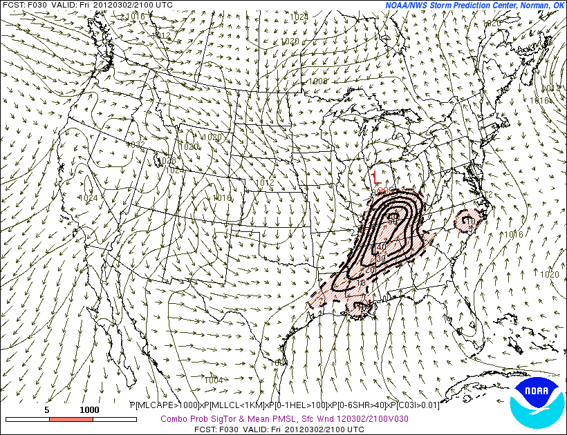
PUBLIC SEVERE WEATHER OUTLOOK
NWS STORM PREDICTION CENTER NORMAN OK
0726 AM CST FRI MAR 02 2012
...SEVERE THUNDERSTORMS EXPECTED OVER PARTS OF THE EXTREME SOUTHERN INDIANA...CENTRAL KENTUCKY...AND NORTHERN MIDDLE TENNESSEE LATER TODAY AND TONIGHT...
THE NWS STORM PREDICTION CENTER IN NORMAN OK IS FORECASTING THE DEVELOPMENT OF A FEW STRONG...LONG-TRACK TORNADOES OVER PARTS OF THE EXTREME SOUTHERN INDIANA...CENTRAL KENTUCKY...AND NORTHERN MIDDLE TENNESSEE LATER TODAY AND TONIGHT.
MORNING WEATHER DATA CONFIRM A VERY MOIST AND UNSTABLE ENVIRONMENT SPREADING NORTHEASTWARD FROM ARKANSAS AND TENNESSEE TOWARD THE LOWER OHIO VALLEY...IN ADVANCE OF A DEEPENING SURFACE LOW PRESSURE SYSTEM IN MISSOURI. THIS SURFACE LOW WILL MOVE TOWARD SOUTHERN LOWER MICHIGAN BY THIS EVENING...ALLOWING THE MOIST/UNSTABLE AIR MASS TO SPREAD TO NEAR OR JUST NORTH OF THE OHIO RIVER PRIOR TO THE PASSAGE OF A COLD FRONT. SEVERE STORMS WILL LIKELY DEVELOP ALONG AND IN ADVANCE OF THE COLD FRONT BY MIDDAY OR EARLY AFTERNOON...AT THE SAME TIME THE WINDS THROUGH ALL LEVELS OF THE ATMOSPHERE WILL BECOME VERY STRONG. THESE FACTORS WILL RESULT IN A FAVORABLE SETUP FOR FAST-MOVING TORNADIC STORMS CAPABLE OF PRODUCING LONG-TRACK/DAMAGING TORNADOES IN THE HIGH RISK AREA OF EXTREME SOUTHERN INDIANA...CENTRAL KENTUCKY...AND NORTHERN MIDDLE TENNESSEE THIS AFTERNOON.
A SEPARATE BAND OR TWO OF SEVERE STORMS IS ALSO EXPECTED THIS AFTERNOON INTO TONIGHT ACROSS CENTRAL/NORTHERN MISSISSIPPI AND ALABAMA INTO NORTHERN GEORGIA...ALONG AND AHEAD OF THE COLD FRONT. CONDITIONS WILL NOT BE QUITE AS FAVORABLE FOR TORNADOES COMPARED TO FARTHER NORTH IN THE HIGH RISK...BUT MULTIPLE SEVERE STORMS WITH A FEW TORNADOES WILL BE POSSIBLE.
I'm a native of far southern IL, in the midst of 'tornado alley', just a little west of the town of Harrisburg that got hammered the other day.
The sight/sound of a twister are a couple of life's unforgettable phenomena.
Disclaimer: Opinions posted on Free Republic are those of the individual posters and do not necessarily represent the opinion of Free Republic or its management. All materials posted herein are protected by copyright law and the exemption for fair use of copyrighted works.