"Resolution of one foot?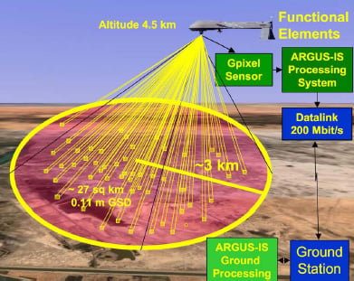
My memory was wrong. From the Nova documentary, Rise of the Drones, the resolution from 17,500 feet was six inches. It showed a man on the ground, waving his arms and a small bird in flight. The system, called ARGUS-IS, is very powerful; able to store one million tera bites/day with a resolution of 1.8 billion pixtels. You can read more about its capabilities here (very interesting):
The 1.8 gigapixel ARGUS-IS
When dealing with a moving imaging platform, raw resolution is not the be-all and end-all that it is for a static image. With a six-inch resolution and a fast repetition rate, a man-sized object would probably be in multiple frames that could be overlaid and composited to synthesize a higher resolution image.
As an analogy, I have identified stone artifacts in the shallows of a lake's wave-swept beach by spotting something unusual and then staring at it during several wave passes. The visibility through any single wave was blurry, but, as my mind built up a composite image from several wave "exposures", the resulting "mental composite" was clear enough to identify the object as a stone projectile point.
Argus, with all its storage and computational power, apparently does not require the ultimate in single-pixel resolution to do its ID and tracking job...
Nonetheless, I was surprised at the single-frame resolution in the latest Google Earth releases. But -- what would you expect from, essentially, a Hubble Space Telescope -- aimed at Earth...? '-)
And, I would be very surprised if the public gets to see the "really good stuff"...