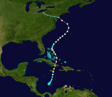
 Tropical Sytem Philippe Track
 Posted on 10/28/2017 4:55:17 PM PDT by topher
Tropical Sytem Philippe Track
Forecast Discussion #5 5:00 PM 28-Oct-2017
000 WTNT43 KNHC 282052 TCDAT3
Tropical Storm Philippe Discussion Number 5 NWS National Hurricane Center Miami FL AL182017 500 PM EDT Sat Oct 28 2017
Satellite images, radar data from Cuba and Key West, and surface observations indicate the depression has turned northward over the past few hours, and has also strengthened into a tropical storm. The initial intensity of 35 kt is based on a surface observation of 35 kt in a brief squall from Grand Cayman at 1444Z, a recent AMSU estimate of 37 kt, and average Key West Doppler radar velocities of 40 kt between 10,000-12,000 ft just north of the Cuban coast; the latter data equates to an approximate surface wind speed of 36 kt.
The initial motion estimate is now 355/25 kt based on radar data and high-resolution GOES-16 visible satellite imagery over the past 2-3 hours. The low-level wind flow pattern for the next 6 hours or so is forecast to be complex, with a new non-tropical surface low having recently formed about 100 nmi west of Key West, Florida. This feature appears to have developed beneath an upper-level jet entrance region ahead of an approaching cold front. The global, regional, and even the convective-scale models are now showing the center of Philippe moving general northward across the Straits of Florida this evening and merging with the non-tropical low around 0000Z. After the merger over Florida Bay, the various models are in good agreement on Philippe moving northeastward to east-northeastward across extreme southern Florida or the Florida Keys overnight as the cyclone is accelerated ahead of the aforementioned frontal system and strong mid-/upper-level trough. After reaching the northwestern Bahamas by 1200Z Sunday morning, Philippe is forecast to accelerate further towards the northeast at forward speeds of 30-35 kt, by Sunday afternoon and evening, remaining well offshore of the Carolinas. By 36 hours, Philippe is expected to pass about midway between Bermuda and the southeastern United States, and gradually getting pulled north-northeastward up the east side of a powerful baroclinic low that is forecast to develop near Cape Hatteras and move northward near the U.S. east coast. The NHC track guidance is in reasonable agreement on this developing track scenario, and lies between the GFS model, which takes Philippe across the Florida Keys, and the ECMWF model, which moves the cyclone farther north over South Florida.
The vertical wind shear affecting Philippe is expected to remain favorable for strengthening to occur for the next 24 hours, along with an additional baroclinic boost from the aforementioned upper-level jet maximum. By 36 hours, strong baroclinic forcing associated with the approaching frontal system are forecast to induce additional strengthening before the cyclone merges with the frontal system and becomes an extratropical low by 48 hours. Dissipation or absorption by a larger extratropical low is expected by 72 hours when the system is located over the cold waters of the North Atlantic.
KEY MESSAGES:
1. Although the center of Philippe is now forecast to move across the Florida Keys or extreme south Florida, most of the strongest winds are expected to remain east and southeast of the center. However, tropical-storm-force winds, mainly in gusts, could occur in brief heavy squalls across the upper Florida Keys and southeast Florida overnight. For that reason, a tropical storm watch remains in effect for these areas.
2. Regardless of the exact track of Philippe, the primary threat from this system will be heavy rainfall that can cause localized flooding across portions of Cuba, the Florida Keys, and South Florida.
FORECAST POSITIONS AND MAX WINDS
INIT 28/2100Z 23.0N 82.6W 35 KT 40 MPH 12H 29/0600Z 26.0N 80.1W 45 KT 50 MPH 24H 29/1800Z 31.5N 75.3W 50 KT 60 MPH 36H 30/0600Z 36.6N 70.5W 55 KT 65 MPH 48H 30/1800Z 42.0N 66.0W 50 KT 60 MPH...POST-TROP/EXTRATROP 72H 31/1800Z...DISSIPATED
$$ Forecaster Stewart
The “remains” of super-Typhoon Nuri are pounding the heck out of Alaska, high winds and rain - with massive flooding in Juneau.
Yet, not a peep on the nat news.
A a bit of wind and rain *might* hit the tip of Fl and it’s quite the to-do......
Joe Bastardi is indicating this could most likely be an event for New England.
Scroll down the page until you see the video selection under his name.
This storm originated in the same place as Sandy and is almost taking the same path.
Are people in Alaska somehow more prepared for storms?
Back in the good old days, this type of thing was ignored. Now the NWS uses a microfine analysis to define some rain as a named storm.
Don’t worry about this being remotely like Sandy, it’s a very weak tropical storm that might peak at 55 mph sustained winds tomorrow, whereas Sandy was a major hurricane leaving the Bahamas and took a nasty westward turn south of Long Island — Philippe is racing northeast and will swerve into Maine on Monday, but there’s already a fairly strong low on track to meet up with it and the whole thing will result in maybe 60 mph peak gusts, 2 inches of rain and a tide increase of less than 2 feet.
Folks in New England just call that weather.
The really noteworthy thing about to happen on the east coast is the arrival of much colder air from the western Great Lakes region. That will be the main weather story.
Yes, and he's got a whole different scenario for this storm system.
https://www.freerepublic.com/focus/f-chat/3599540/posts
Hurricane force winds coming to Upper NE/New Brunswick- 90 to 100 mph gusts!
Not correct at all. Sandy tracked over eastern Cuba as a Cat 3. This is just a marginal tropical storm along western Cuba.
Sandy:
Philippe:
And completely different atmospheric conditions. There was a high over the Canadian Maritimes that blocked Sandy and steered her into Jersey. There is a very strong trough along the East Coast that will send Philippe into the Maritimes - and Philippe is probably not even the main player - another low a bit further north is supposed to form a N'oreaster off Hatteras and plow into New England and the Maritimes.
Philippe remains a poorly organized storm. Crossing SFL
tonight w/ gusts to 50 mph & 2-4"+ of rain

Disclaimer: Opinions posted on Free Republic are those of the individual posters and do not necessarily represent the opinion of Free Republic or its management. All materials posted herein are protected by copyright law and the exemption for fair use of copyrighted works.