Do not post webcams or satellite loops. Use links instead. This is a high traffic thread.

I don't believe it's going to curve up as thought regardless of the high pressure system. More than likely, it will hit below Corpus and at most may severely impact Victoria, Texas. So stated this day, Sep. 21, at 6:42 p.m.
The house can be re-built. Maybe you can send the pets out with someone? Some hospitals even make a kennel area for staff pets. Your wife might get an ok to put them in an office or something by agreeing to stay. It wouldn't hurt to ask.
Does your faith need a jumpstart right now?
Have an interview with God:
http://www.reata.org/interview2.html
:)
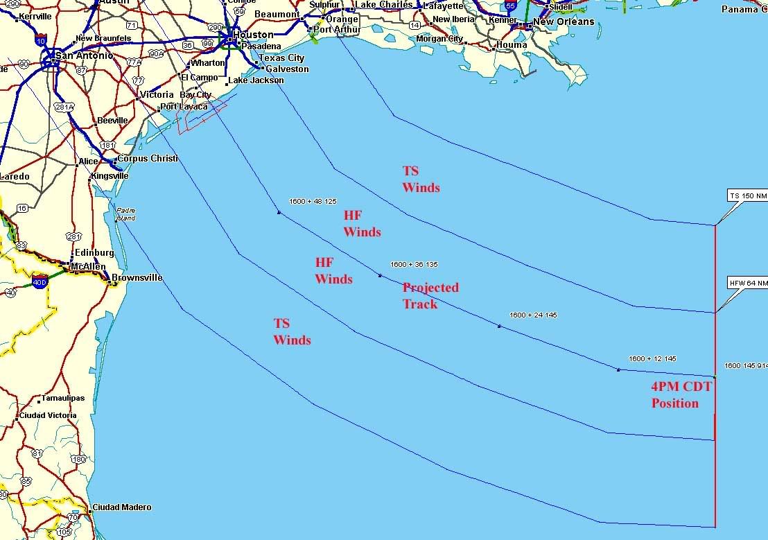
Are you saying the new model runs have landfall moving north of the Matagorda Bay area to the Freeport/South Galveston Island area?
My God!

You guys aren't the only ones getting hammered with bad weather. September 21rst and we're getting tornadoes in the Twin Cities area.
You have been doing a fantastic job on FR of late. Thank you.
To all our Texas Freepers.... Hope you ride this one out safely! Keep you in my prayers.
Something very peculiar is going on.
TWC - Rita's gone under 899 mb. The 7 pm CDT advisory should be out shortly.
000
WTNT63 KNHC 212351
TCUAT3
HURRICANE RITA TROPICAL CYCLONE UPDATE
NWS TPC/NATIONAL HURRICANE CENTER MIAMI FL
650 PM CDT WED SEP 21 2005

...RITA BECOMES THE THIRD MOST INTENSE HURRICANE ON RECORD...

DROPSONDE DATA FROM AN AIR FORCE RESERVE UNIT RECONNAISSANCE
AIRCRAFT AT 623 PM CDT...2323Z...INDICATED THE CENTRAL PRESSURE HAS
FALLEN TO BELOW 899 MB...OR 26.55 INCHES. THE DROPSONDE INSTRUMENT
MEASURED 32 KT/35 MPH WINDS AT THE SURFACE...WHICH MEANS IT LIKELY
DID NOT RECORD THE LOWEST PRESSURE IN THE EYE OF RITA. THE CENTRAL
PRESSURE IS PROBABLY AT LEAST AS LOW AS 898 MB...AND PERHAPS EVEN
LOWER. FOR OFFICIAL PURPOSES... A PRESSURE OF 898 MB IS ASSUMED...
WHICH NOW MAKES RITA THE THIRD MOST INTENSE HURRICANE IN TERMS OF
PRESSURE IN THE ATLANTIC BASIN. SOME ADDITIONAL DEEPENING AND
INTENSIFICATION IS POSSIBLE FOR THE NEXT 12 HOURS OR SO.

RITA CURRENTLY RANKS BEHIND HURRICANE GILBERT IN 1988 WITH 888 MB
AND THE 1935 LABOR DAY HURRICANE WITH 892 MB.

FORECASTER STEWART
HERE'S THE LASTEST FROM SAN ANTONIO, TX.
To start, thanks for these threads and all your hard work, NN.
San Antonio Hotel and Lodging Asso. says 98% hotels are full. Closest are in Lubbuck, Amarillo0 and El Paso.
ALL evacuees need to go to McCreless Mall at I-37 and Southcross Rd. It is a "shelter hub" and can give you directions to all San Antonio shelters and as one shelter fills up, they can send you to others as they open up. GO TO THE MALL FIRST. IT IS OUR STAGING AREA.
Freeman Coliseum (SBC Center) has 183 acres of land and all of those barns we use for the live stock show
to house large live stock coming to town and will also train all those who want to help the Red Cross. (use the West entrance off Commerce St.)
There are 100's of FEMA 18-wheelers, with more coming, full of ice, water, cots and other supplies being staged at Fort Sam Houston and 150+, with more coming busses being staged at Camp Bullis.
Lots of stuff going on in San Antonio as we again gear up to help folks out. I'll update when I get it.
Carl
...Category five Hurricane Rita continuing to deepen...
...Now the third most intense hurricane in the Atlantic Basin
   on record...
a Hurricane Watch has been issued for Gulf of Mexico coast from Port
Mansfield Texas to Cameron Louisiana.
A tropical storm watch has been issued for east of Cameron to Grand
Isle Louisiana and from south of Port
Mansfield to Brownsville.
The government of Mexico has issued a tropical storm watch for the
northeast coast of Mexico from Rio San Fernando northward.
A Hurricane Watch means that hurricane conditions are possible
within the watch area...generally within 36 hours. A tropical storm
watch means that tropical storm conditions are possible within the
watch area...generally within 36 hours.
Interests in the northwestern Gulf of Mexico should monitor the
progress of dangerous Hurricane Rita.
For storm information specific to your area...including possible
inland watches and warnings...please monitor products issued
by your local weather office.
At 7 PM CDT...0000z...the eye of Hurricane Rita was located near
latitude 24.5 north...longitude 86.8 west or about 580 miles
east-southeast of Galveston Texas and about 680 miles east-southeast
of Corpus Christi Texas.
Rita is moving toward the west near 13 mph and this motion is
expected to continue during the next 24 hours.
Maximum sustained winds are near 165 mph...with higher gusts. Rita
is an extremely dangerous category five hurricane on the
Saffir-Simpson scale. Some fluctuations in intensity are likely
during the next 24 hours.
Hurricane force winds extend outward up to 70 miles from the
center...and tropical storm force winds extend outward up to 175
miles.
Pressure has been falling rapidly during the day and the latest
minimum central pressure recently reported by an Air Force
reconnaissance plane was 898 mb...26.55 inches. This makes Rita the
third most intense hurricane in terms of pressure in the Atlantic
Basin.
Tides are currently running near normal along the Mississippi and
Louisiana coasts in the areas affected by Katrina. Tides in those
areas will increase up to 3 to 4 feet over the next 24 hours with
large waves on top and residents there could experience flooding.
Repeating the 7 PM CDT position...24.5 N... 86.8 W.  Movement
toward...west near 13 mph.  Maximum sustained winds...165 mph.
Minimum central pressure...898 mb.
The next advisory will be issued by the National Hurricane Center
at 10 PM CDT.
Forecaster Stewart/landsea
$$
Best estimates, uncomfortable posting these, it's very early to project this kind of thing on the basis of a computer modelled landfall this far in advance....but here you go:
http://i4.photobucket.com/albums/y138/jeffers_mz/Rita/01myforecast.jpg
http://i4.photobucket.com/albums/y138/jeffers_mz/Rita/01myforecastzoom.jpg
This picture is BEYOND ASTONISHING.
http://www.easternuswx.com/bb/uploads/post-813-1127348907.jpg
Wow. Wow. Wow.
Steve Lyon just said something about a stall. moving north now. caught end of it. we need to check this out
Watermark (again already?)
Reply to #1,759
Got your pen and paper ready for the dead count,
there TR?
Nice & kewl at my place. The plane landing in LA took away from Rita coverage. I haven't seen the latest view of her/it. We are having very light rain, almost like a mist.