Posted on 02/20/2008 7:28:52 PM PST by blam
Satellites spot lost Guatemala Mayan temples
Wed Feb 20, 2008 1:29pm EST
GUATEMALA CITY (Reuters) - Ancient Mayan astronomers aligned their soaring temples with the stars and now modern archeologists have found the ruins of hidden cities in the Guatemalan jungle by peering down from space.
Archeologists and NASA scientists began teaming up five years ago to search for clues about the mysterious collapse of the Mayan civilization that flourished in Central America and southern Mexico for 1,000 years.
The work is paying off, says archeologist William Saturno, who recently discovered five sprawling sites with hundreds of buildings using a spy satellite that can see through clouds and forest to reveal differences in the vegetation below.
Saturno said the satellite images made it infinitely easier to find ruins covered for centuries by dense jungle vines and trees. "It was like shooting fish in a barrel," he said.
Saturno first sought out satellite images to find a source of water near his excavation camp at San Bartolo, which lies 32 miles from the nearest town on inaccessible roads deep in Guatemala's northern Peten region.
NASA gave him a snapshot of solar radiation reflected off the wide variety of plants in the region. Saturno was surprised to see a pattern of discoloration in the satellite image that outlined some of the buildings he had already uncovered.
Using a GPS device, he pinpointed on a map the location of other discolorations nearby and discovered several areas with hidden Mayan architecture.
The Maya built with limestone and lime plasters. As the abandoned buildings disintegrate, chemicals from the stones seep into the soil, keeping some plants from growing around the structures and affecting the chemistry of those that do grow. The satellite can spot these differences and the result is a virtual road map of the buried structures from nearly 400 miles above Earth's surface.
CLUES TO COLLAPSE
Saturno said he expects more discoveries like his 2001 find of an elaborate mural from around 100 B.C. depicting the Mayan creation myth, dubbed the Sistine Chapel of the Mayan world.
His research partner at NASA, Tom Sever, hopes the satellite images could provide clues as to why the Mayan civilization collapsed around 900 A.D.
"What we are investigating is the choices the Maya made that ultimately created a catastrophic situation for them," Sever said by telephone from a NASA base in the U.S. state of Alabama.
To support a population boom the Maya felled huge swathes of jungle for agriculture. They collected water in giant reservoirs called "bajos" to farm during seasonal dry spells, but the deforestation raised temperatures and reduced rainfall, drying up water sources, Sever said.
Bajos were found at around half the new sites located by the satellite, potentially boosting this theory of why the Maya had to leave their cities.
Information about the fate of the Maya could help modern societies make better choices and "avoid the sometimes disastrous mistakes of the past," said Sever. "We are in a race against time to preserve our history."
(Writing by Mica Rosenberg; Editing by Catherine Bremer and David Wiessler)
GGG Ping.
NAFTA was seen written on the ruins
Asking the locals would have been easier, quicker, and less expensive but then they wouldn't be able to claim they "discovered" something that was never lost.
“but the deforestation raised temperatures and reduced rainfall, drying up water sources, Sever said. “
I’ll call B.S. on that line. Local deforestation, no matter how severe is not going to change the pattern of rainfal in Central America. Droughts are caused by changes in the water vapor weather patterns of the globe which are causedby... THE SUN, not Kinich and his stone axe.
Duh - wouldn't this be more significant than CO2?
Besides, according to the upcoming movie, professor Jones and son already unearthed the Crystal Skull from there in the late fifties.
Ask the locals? LOL!
Out of curiosity, the article only mentions “for 1,000 yrs” what time frame did these buildings come into existence?
LOL! I once met a man who craved membership in the Explorers Club. He had to make a genuine discovery, so he packed off to Guatemala, hired a guide, drove to the most remote area and started asking around about ruins. He was finally steered to some vine encrusted mounds deep in the jungle, documented the find, and was accepted into the brotherhood.
~~~~
Cartography, GIS, GPS, and various remote sensing (overhead imagery) techniques are some of my primary research tools in archaeology.
We are, at present, trying to arrange a LIDAR overflight over a heavily forested area where we know a complex of 30 large Caddo dwelling mounds surrounding one "big (temple?) mound" are located.
LIDAR is claimed to produce elevation images with as good as 2" (two inch!) vertical resolution. It produces an "elevation point cloud" -- with points returned off of the tops of the trees, and a lower set where the laser light penetrates through the vegetation to the ground surface. By subtracting out the canopy-top point set, an amazingly detailed elevation dataset can be produced.
Then, by applying pseudo-shadowing convolutions (spatial filters), a strikingly realistic and detailed "3-D" ground surface image can be generated.
We are already applying LIDAR to the mapping of long-unused historic roads, trails, and "traces" -- including the famous 1813 "Trammel's Trace" on which I am doing research...

This was confirmed when the writings of the venerable Mayan weatherman, Tonto Algore, were recently deciphered.
I focused my research on locating the "Wye" or "Y" where the traces joined. When I did so, I found that it was at the site of a town -- that vanished in 1866 -- which was a nexus of several important very early roads. We are planning a detailed on-the-ground archaeological survey of the "Old Unionville" townsite later this month.
THC (Texas Historical Commission) has just approved my application for a State Historical Marker at the location shown in the (resolution and size both reduced 50% as a courtesy to FR) photo below. It is one of the few known places where the remains of Trammel's Trace are clearly visible from a State highway. (The "marker" shown is totally computer-generated -- it resides only in my Macintosh -- and now, in my webspace...)
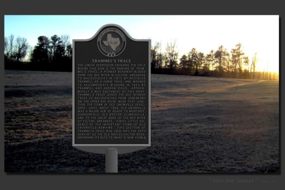
Should you wish to view the image at full-res, you can do so here. (The barbed wire fence visible at lower right marks the highway ROW where the marker will be placed...)
The buildings were built anywhere from about 600 AD to 1000 AD before the Mayan empire collapsed.
I worked on the outer-area search project at Tikal for a few weeks and we found worker settlements (usually 3-6 house mounds and a chultun (storage area underground).
We did it the old way. Used Mayan and Mexican Indians to bush out the old oil prospectors trails and then went off about 50 meters on each side of the trail, recorded what we found, and then moved on outward about 20 clicks.
We did find one small temple (and a handful of baby scorpions). July 1966.
Never use an American machete in a jungle. Go with the longer Philippino ones. Won’t take your foot off.
Neat, thanks.
LOL!
|
|
|||
Gods |
Thanks Blam and TXnMA. |
||
|
· Mirabilis · Texas AM Anthropology News · Yahoo Anthro & Archaeo · · History or Science & Nature Podcasts · Excerpt, or Link only? · cgk's list of ping lists · |
|||
Disclaimer: Opinions posted on Free Republic are those of the individual posters and do not necessarily represent the opinion of Free Republic or its management. All materials posted herein are protected by copyright law and the exemption for fair use of copyrighted works.