Free Republic
Browse · Search
News/Activism
Topics · Post Article

Skip to comments.

High Risk Of Severe Weather Saturday (Nebraska, Kansas, Oklahoma, Iowa)
Wunderground.com ^ | 4/13/12 | Sean Tanner

Posted on 04/13/2012 3:20:25 AM PDT by dirtboy

Edited on 04/14/2012 10:35:01 AM PDT by Admin Moderator. [history]

The Storm Prediction Center has predicted a slight chance of severe weather for parts of Texas and Oklahoma this entire week, thus it should come as no surprise that the weekend holds the best chance of dangerous severe weather.

The Storm Prediction Center has issued an upgraded, high chance of severe weather from central Oklahoma through eastern Kansas (see image below). In addition, there is a moderate risk of severe weather from western Texas through southern Iowa, and a slight risk in the greater area from central Texas through southern Wisconsin.

I cannot stress the severity of this situation enough. Residents living in these regions should prepare for severe weather on Saturday.


TOPICS: News/Current Events; US: Iowa; US: Kansas; US: Nebraska; US: Oklahoma
KEYWORDS:
Navigation: use the links below to view more comments.
first previous 1-2021-4041-6061-80 ... 101-115 next last
To: Big Red Clay

Stay safe. You have a basement, right? Sounds like a good day to make a very comfortable man cave.


21 posted on 04/14/2012 7:16:03 AM PDT by FourPeas ("Maladjusted and wigging out is no way to go through life, son." -hg)
[ Post Reply | Private Reply | To 13 | View Replies]

To: dirtboy

So now I have A Whole Lot More family in the high risk area. This could be a very bad day. That High Risk area is massive.


22 posted on 04/14/2012 7:19:25 AM PDT by FourPeas ("Maladjusted and wigging out is no way to go through life, son." -hg)
[ Post Reply | Private Reply | To 12 | View Replies]

To: FourPeas
It was two separate areas when I posted it earlier. They just merged them and made the overall area larger. That is a HUGE swath of high-risk, don't recall seeing one bigger.

Which means they are seeing worsening conditions. Everyone in the area of the high and moderate risk should pay VERY close attention before venturing out this afternoon and evening and review their plans as to what to do at home in case of a tornado warning.

23 posted on 04/14/2012 7:25:11 AM PDT by dirtboy
[ Post Reply | Private Reply | To 22 | View Replies]

To: FourPeas

The NWS Storm Prediction Center in Norman had a close brush with a tornado yesterday:

http://www.weather.com/outlook/weather-news/news/articles/tornado-norman-oklahoma_2012-04-14


24 posted on 04/14/2012 7:35:33 AM PDT by dirtboy
[ Post Reply | Private Reply | To 22 | View Replies]

To: dirtboy

They certainly had a good view. I was watching several storm spotters near OKC yesterday during that time. I thought I heard one saying that for today the NWS has activated a back-up location at an Air Force Base in ND(?). That’s pretty telling.

I usually gauge how severe the weather will be based on the number of storm spotters on WeatherTAP. Yesterday it looked like they were re-inacting a cattle drive using storm spotters.


25 posted on 04/14/2012 7:48:19 AM PDT by FourPeas ("Maladjusted and wigging out is no way to go through life, son." -hg)
[ Post Reply | Private Reply | To 24 | View Replies]

To: Big Red Clay; FourPeas
The risk is even higher up in SE Nebraska:


26 posted on 04/14/2012 7:49:02 AM PDT by dirtboy
[ Post Reply | Private Reply | To 13 | View Replies]

To: dirtboy
Everyone in the area of the high and moderate risk should pay VERY close attention before venturing out this afternoon and evening and review their plans as to what to do at home in case of a tornado warning.

Bears repeating.

27 posted on 04/14/2012 7:51:40 AM PDT by FourPeas ("Maladjusted and wigging out is no way to go through life, son." -hg)
[ Post Reply | Private Reply | To 23 | View Replies]

To: FourPeas

28 posted on 04/14/2012 7:54:30 AM PDT by FourPeas ("Maladjusted and wigging out is no way to go through life, son." -hg)
[ Post Reply | Private Reply | To 27 | View Replies]

To: All

The percentages in the map indicate the forecast chance of a tornado hitting within 25 miles. The hatched areas are forecasts for stronger tornadoes - EF2 to EF5.


29 posted on 04/14/2012 7:54:33 AM PDT by dirtboy
[ Post Reply | Private Reply | To 26 | View Replies]

To: FourPeas
Convection already starting to fire:

Atmosphere is juicing up:

Significant Tornado Potential (STP) already high, will probably reach near-peak levels later in the day (it's only 10 AM now and the elements are still converging for this event:


30 posted on 04/14/2012 8:04:33 AM PDT by dirtboy
[ Post Reply | Private Reply | To 28 | View Replies]

To: dirtboy

Great info. Thanks.


31 posted on 04/14/2012 8:13:27 AM PDT by FourPeas ("Maladjusted and wigging out is no way to go through life, son." -hg)
[ Post Reply | Private Reply | To 30 | View Replies]

To: FourPeas

32 posted on 04/14/2012 8:25:20 AM PDT by dirtboy
[ Post Reply | Private Reply | To 31 | View Replies]

To: FourPeas

Already severe storm warnings in Kansas and Nebraska.


33 posted on 04/14/2012 8:38:40 AM PDT by dirtboy
[ Post Reply | Private Reply | To 31 | View Replies]

To: dirtboy

Predictive weather software is fascinating. At times when I’ve compared prediction v. actual, it’s been amazingly accurate. Such sophisticated algorithms...as a former programmer it would be a blast to work on. And, we’re learning so much more as time goes by. What an great time in which to live. I may only be able to sit back and appreciate the advances being made, but I still get excited for the geeks who get to do it.


34 posted on 04/14/2012 8:43:38 AM PDT by FourPeas ("Maladjusted and wigging out is no way to go through life, son." -hg)
[ Post Reply | Private Reply | To 32 | View Replies]

To: FourPeas

The scary thing about that STP animation is that at one point the high levels extend from the Rio Grande to northern Nebraska.


35 posted on 04/14/2012 8:47:04 AM PDT by dirtboy
[ Post Reply | Private Reply | To 34 | View Replies]

To: dirtboy

Whoa. I’m I seeing it correctly, that there’s already areas reporting 2.5” hail (near Arcadia, KS)? Before 11AM? Eek.


36 posted on 04/14/2012 8:52:44 AM PDT by FourPeas ("Maladjusted and wigging out is no way to go through life, son." -hg)
[ Post Reply | Private Reply | To 33 | View Replies]

To: FourPeas
Dang, already have a PDS tornado watch:

Particularly Dangerous Situation Tornado Watch 165


37 posted on 04/14/2012 9:00:53 AM PDT by dirtboy
[ Post Reply | Private Reply | To 36 | View Replies]

To: dirtboy

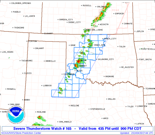
NWS is going to be busy today.

A PDS already...it’s getting ugly early.


38 posted on 04/14/2012 9:05:31 AM PDT by FourPeas ("Maladjusted and wigging out is no way to go through life, son." -hg)
[ Post Reply | Private Reply | To 35 | View Replies]

To: dirtboy

Perhaps the only good thing about this PDS is that much of the area is flat and sparsely populated.


39 posted on 04/14/2012 9:10:47 AM PDT by FourPeas ("Maladjusted and wigging out is no way to go through life, son." -hg)
[ Post Reply | Private Reply | To 37 | View Replies]

To: FourPeas

The PDS watches for the larger cities in the area - OKC, Tulsa, Wichita, Topeka, KC, Lincoln, Omaha - will come later. The jet stream is going to be racing right over the high risk area at over 100 mph. Throw in strong surface-level winds at a 45 degree angle to the jet and you have the ingredients to incorporate rotation.


40 posted on 04/14/2012 9:21:56 AM PDT by dirtboy
[ Post Reply | Private Reply | To 39 | View Replies]


Navigation: use the links below to view more comments.
first previous 1-2021-4041-6061-80 ... 101-115 next last

Disclaimer: Opinions posted on Free Republic are those of the individual posters and do not necessarily represent the opinion of Free Republic or its management. All materials posted herein are protected by copyright law and the exemption for fair use of copyrighted works.

Free Republic
Browse · Search
News/Activism
Topics · Post Article

FreeRepublic, LLC, PO BOX 9771, FRESNO, CA 93794
FreeRepublic.com is powered by software copyright 2000-2008 John Robinson