
Posted on 09/04/2017 2:02:19 PM PDT by NautiNurse
While thoughts and prayers are with our Texas FRiends and neighbors, we are at the peak of the Atlantic Tropical Storm season. Hurricane Irma continues its trek from Cape Verde across the pond and toward the Hebert Box (see below). People with interests in the Southeastern U.S. and Gulf of Mexico should be alert to the forecast path updates for this powerful storm. It is important to note that the average NHC track errors are about 175 and 225 statute miles at days 4 and 5, respectively.
Hurricane Irma originally had a small wind field. In the past 24 hours, however, the wind field has expanded with hurriance force winds up to 40 miles from the center, and tropical storm force winds up to 140 miles from the storm center.
FL Governor Rick Scott reminds Floridians: Families should take time today to make sure you have a disaster plan and fully-stocked Disaster Supply Kit. Florida residents from West Palm Beach to Tampa Bay are heeding the alert. Store shelves are emptying of bottled water.


Mash image to find lots of satellite imagery links
Public Advisories
NHC Discussions
NOAA Local Weather Statements/Radar San Juan, Puerto Rico
NHC Local Weather Statements/Radar Miami, FL
NHC Local Weather Statements/Radar Key West, FL
Buoy Data Caribbean
Buoy Data SE US & GOM

Hebert Box - Mash Pic for Tutorial
Credit: By J Cricket - Modification of map from Wiki
914mb
winds still 185
also we now have THREE hurricanes in the Atlantic
You are very welcome~ Have a very safe trip!
“...unless you’re in a fortified structure designed to withstand it that will not flood.”
Not that I’d necessarily wanna do it but I’ve wondered how well a person could ride out a hurricane in a place like Fort Jefferson in the Dry Tortugas.
That fort has been around since before the Civil War and still seems to be structurally sound.
I’m not versed on this at all myself. I am just assuming (almost invariably a mistake) that the inspectors know how to count containers - whether melted or not. So if that is true, I’m wondering if it could even be problematic to have the containers even if empty. Although it is also true the inspectors have ways of knowing if hydrocarbons such as gas were in the vicinity and contributed to the flames. They are pretty amazing in their inspection techniques.
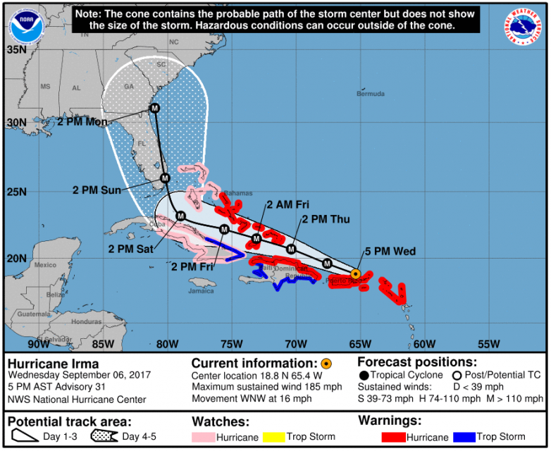
Hurricane Irma Discussion Number 31
NWS National Hurricane Center Miami FL AL112017
500 PM AST Wed Sep 06 2017
The eye of Irma passed over the northernmost Virgin Islands earlier
this afternoon and it is now located just to their northwest. The
satellite and radar presentation of the hurricane remains extremely
impressive. An Air Force Reserve reconnaissance aircraft reported
peak SFMR winds of 156 kt and flight-level winds of 164 kt during
its mission this afternoon. Although there have been no SFMR or
flight-level winds as high as what was observed yesterday, the
initial intensity remains 160 kt, due to the potential of
undersampling. Dropsonde observations in the eye indicated that the
pressure rose a few millibars this morning, but the most recent
aircraft report shows that the pressure has fallen to 914 mb.
The hurricane remains on a west-northwestward motion at about 14
kt. A high pressure ridge over the western Atlantic is forecast to
keep Irma on a west-northwestward course over the next 48 to 72
hours. The track guidance is still in good agreement during that
period, and little change to the NHC forecast was required. By the
weekend, a shortwave trough diving southward over the east-central
United States is expected to cause Irma to turn northwestward and
northward. The 12Z guidance has generally shifted slightly
westward, closer to the previous NHC forecast. As a result, little
overall change was made to the 4-5 day track forecast. The NHC
track is once again close to the HFIP corrected consensus model.
This is also near the 12Z GEFS ensemble mean, but a little east of
the latest ECMWF ensemble mean. Users are reminded that the average
NHC track errors at days 4 and 5 are about 175 and 225 miles,
respectively.
Low vertical wind shear and warm waters along the forecast track of
Irma should allow it to remain a very powerful hurricane during the
next several days, and the intensity forecast is again near the
upper-end of the guidance and is the same as the previous advisory
through 96 hours. Increasingly southwesterly shear and potential
land interaction late in the period is expected to cause some
decrease in Irma’s strength by day 5.
Efforts to provide the forecast models with as much data as possible
continue, with 6-hourly NWS balloon launches across much of the
continental United States, and the NOAA G-IV aircraft currently
sampling the environment around the storm.
KEY MESSAGES:
1. Irma is a potentially catastrophic category 5 hurricane and will
bring life-threatening wind, storm surge, and rainfall hazards to
Puerto Rico tonight, the northern coast of Hispaniola Thursday, and
the Turks and Caicos and southeastern and central Bahamas Thursday
and Friday.
2. Hurricane watches are in effect for the northwestern Bahamas and
much of Cuba. Irma is likely to bring dangerous wind, storm surge,
and rainfall to portions of these areas on Friday and Saturday.
3. The threat of direct hurricane impacts in Florida over the
weekend and early next week has increased. Hurricane watches could
be issued for portions of the Florida Keys and the Florida peninsula
on Thursday.
FORECAST POSITIONS AND MAX WINDS
INIT 06/2100Z 18.8N 65.4W 160 KT 185 MPH
12H 07/0600Z 19.6N 67.6W 155 KT 180 MPH
24H 07/1800Z 20.7N 70.4W 150 KT 175 MPH
36H 08/0600Z 21.5N 73.1W 145 KT 165 MPH
48H 08/1800Z 22.2N 75.6W 140 KT 160 MPH
72H 09/1800Z 23.2N 79.0W 135 KT 155 MPH
96H 10/1800Z 26.0N 80.2W 125 KT 145 MPH
120H 11/1800Z 31.0N 81.0W 105 KT 120 MPH
Meanwhile Two More Hurricanes Form: Jose Right Behind Irma, Katia In The Gulf

Heartbreaking news about Barbuda.
Wind direction. I’ve been in a couple of hurricanes (100mph+) where I was actually in a beachfront hotel. The hotel room had a patio on the beach side and another one on the highway or “bay side”. On the beach side, the floor to ceiling sliding doors were bowing in from the wind. You didn’t dare attempt to open them and the heavy curtains were drawn just to catch any flying glass should the sliding doors fail. On the bay side, you could sit out on the patio and enjoy a refreshing beverage while watching the air conditioning cowlings sail off from the roof above, down into the parking lot and listening to the cacophony of car alarms.
Of course, after a while the storm passes over you and the wind changes direction and you abandon the bayside and head back out to the beachfront patio...
how much increasing wind shear is there expected to be over FL do you know?
this is the second time the NHC center has mentioned it..
That may be the only hope...I really thought this nightmare can’t be happening but models very consistent

On/Off Hurricane List Mash Here--> 
Good. Hope your trip is fast and uneventful.
“That order is probably coming late Wednesday or early Thursday,” Mayor Carlos Gimenez told reporters Tuesday.
He said county evacuation zones A and B would be the target of the order, but that future orders may broaden the evacuation target.
map: http://www.miamiherald.com/latest-news/article171361392.ece/binary/evacuationzonemap2013.pdf
It sounds as if zone B is considered in danger from the surge and will be ordered out tomorrow.
We’ll see if buildings like the Portofino were REALLY designed and built to withstand cat 5 canes.
ABS Television/Radio · 20:16 Due to delays caused by weather conditions, Prime Minister Gaston Browne has departed for Barbuda.
Prime Minister will provide a telephone update from Barbuda to us.
1 hr
ABS Television/Radio
ABS Television/Radio · 1:00:38 PRIME MINISTER BROWNE REPORTS 90% OF THE HOUSING STOCK IN BARBUDA TOTALLY DESTROYED. ONE FATALITY.
42 mins
this is where all that tourist money should help...IF the pols haven’t pocket it.
Has Shep Smith started telling people in Miami they’re all dead yet? Not interested until the fool is melting down.
I can’t find the link but found a simulation site a couple days where you could click and it would tell you the surge feet,,,zone B is a CAT 2...and if I recall correctly 6 feet for a CAT 4-5 would be in those zones...and of course waves on top of that
they are stupid for staying and they better hope the storm stays east
I’m not sure what affect the angle it is coming will have on the surge either....
also the storm will get even bigger in size which means more surge
Disclaimer: Opinions posted on Free Republic are those of the individual posters and do not necessarily represent the opinion of Free Republic or its management. All materials posted herein are protected by copyright law and the exemption for fair use of copyrighted works.
