
Posted on 09/07/2017 8:09:47 AM PDT by NautiNurse
View from Sugarloaf Mountain NE of Orlando.


Unfortunately the upper level steering currents look to prevent that. But, if the storm pushes any south it could track further west, and interaction with Cuba could also shred it and then it is anybodies guess what happens. But, those are very very low probabilities.
There is a low running from the central US down to the western gulf. This would force a North and then NE turn. However there is also a strong High pressure ridge over the Eastern States that is what has kept Irma pushed down on the track she is on. As she gets past that High the backside of if will steer her NW and then North. That has been the forecast all along - she will turn and ride the slot in between the High and the Low. And that turn is almost a garaunteed certainty.
The question is timing. All the models predicted the High degrading and the low pushing East, that would have produced the early turn. But as time as gone on the high has persisted and the low has ben blocked -- resulting in a constant move Westward on all the models.
Unless something drastic happens to blow the high out, and nothing looks strong enough to do that, Irma will track west and then catch the slot around Key West and ride straight up the West Coast of FLA.
What we need to pray for now is more and more interaction with Cuba to weaken here down from Cat 4/5
“40,000 cats? Surely you jest.”
Because you can’t stop at just a dozen.
Don’t forget Highland County FL...it has a hill too.
I don’t think it’s going to turn north. Something tells me it’s going to end up in the Gulf of Mexico.
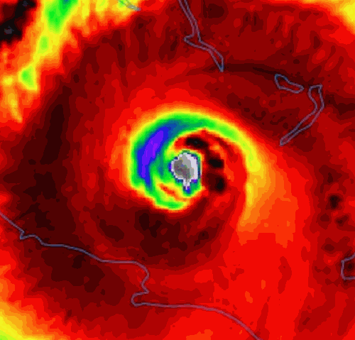
Looks like the eye of Mordor.
Do you have a source reference for your prediction?
Oh my! Reminds me of the old lady my mom and I used to help. 80 cats easily.
Be a shame if it slammed into Castro-Land.
***As of now they don’t know my address, city etc.***
If I were you, I’d keep it that way. You’ll be opening up a can of worms otherwise. You can still be compassionate in other ways.
By 5pm this evening we'll be close. By 10PM I think we know. West vs East. Not looking good. She is turning more left. West track support. pic.twitter.com/swTGQTMsqG— crankyweatherguy (@crankywxguy) September 8, 2017

“I think that was a joke.”
Well, if it wasn’t before it is now.
No it wouldn't, those mountains would likely cause the storm to become disorganized and lose a great deal of wind speed.
Disclaimer: Opinions posted on Free Republic are those of the individual posters and do not necessarily represent the opinion of Free Republic or its management. All materials posted herein are protected by copyright law and the exemption for fair use of copyrighted works.