Skip to comments.
Scientists Prove Limestone Can Form Quickly
Institute for Creation Research ^
| 6-7-18
| Tim Clarey, PhD
Posted on 06/08/2018 8:08:27 AM PDT by fishtank
click here to read article
Navigation: use the links below to view more comments.
first previous 1-20, 21-40, 41-60, 61-80, 81-94 next last
To: Nifster
Nifster:
"Unfortunately carbon dating is used to claim much longer time periods.
It’s use gets shakier and shakier as science finds new methods." Only if your term "carbon dating" itself is misused.
Carbon dating is only one of dozens of different methods for finding ancient ages -- it works back to ~60,000 years:
"Radiocarbon dating (usually referred to simply as carbon-14 dating) is a radiometric dating method.
It uses the naturally occurring radioisotope carbon-14 (14C) to estimate the age of carbon-bearing materials up to about 58,000 to 62,000 years old.""The older a sample is, the less 14 C there is to be detected, and because the half-life of 14 C (the period of time after which half of a given sample will have decayed) is about 5,730 years, the oldest dates that can be reliably measured by this process date to around 50,000 years ago, although special preparation methods occasionally permit accurate analysis of older samples."
This site lists dozens of radiometric dating methods.
This site lists dozens of methods, including radiometric dating.


61
posted on
06/09/2018 7:29:45 AM PDT
by
BroJoeK
((a little historical perspective...))
To: Nifster
Nifster:
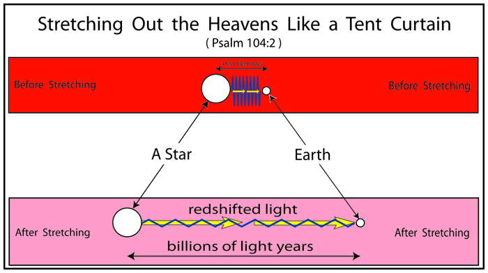
"Stretching out a canopy does not in and of itself imply anything.
Allegory should never be assumed to be scientific." Of course, but it strikes me as most curious how often text written down for ancient shepherds & farmers can be read as predicting modern science.
Indeed, in the process of disputing me you admit the verse is allegorical -- allegorical of what?
Why not allegorical of a modern scientific explanation?


62
posted on
06/09/2018 7:43:48 AM PDT
by
BroJoeK
((a little historical perspective...))
To: fishtank; dirtboy
fishtank:
"Catastrophic Plate Tectonics - Key to Understanding..."Ocean spreading is one of the more direct & simple measurements of ancient time.
Measured today at 2-3 inches per year, which equates to ~50 miles in a million years, we can count up the mid-ocean ridges to see how long they've been there.


63
posted on
06/09/2018 8:20:08 AM PDT
by
BroJoeK
((a little historical perspective...))
To: BroJoeK
64
posted on
06/09/2018 8:22:23 AM PDT
by
dfwgator
(Endut! Hoch Hech!)
To: UpInArms; dirtboy
UpInArms:
"This link explains, better than I can, a different paradigm than the one most held to be true that the fossil record indicates formation that took millions of years to occur.
The data is not being ignored..." Or, more accurately: only data which contradicts this "hypothesis" is ignored.
65
posted on
06/09/2018 8:47:46 AM PDT
by
BroJoeK
((a little historical perspective...))
To: hopespringseternal; dirtboy
hopespringseternal:
"Still waiting for you to post anything that disproves what I said.
Millions of years of erosion and seismic activity would create massive differences in layer placement and thickness everywhere.
Instead you see the opposite — layers are remarkably consistent in thickness and depth." In what way does this example from the Grand Canyon support such claims?

66
posted on
06/09/2018 9:05:19 AM PDT
by
BroJoeK
((a little historical perspective...))
To: dfwgator
67
posted on
06/09/2018 9:08:46 AM PDT
by
BroJoeK
((a little historical perspective...))
To: BroJoeK
The layers look remarkably consistent in thickness and depth.
To: BroJoeK
And ocean crust gets subducted, which is why the ocean floor is a lot younger geologically than most continental crust.
69
posted on
06/09/2018 11:12:09 AM PDT
by
dirtboy
To: hopespringseternal
They are not. A simple query would tell you that, so apparently you are not interested in engaging in informed debate.
70
posted on
06/09/2018 11:13:27 AM PDT
by
dirtboy
To: hopespringseternal
Millions of years of erosion and seismic activity would create massive differences in layer placement and thickness everywhere. Instead you see the opposite — layers are remarkably consistent in thickness and depth. Even your picture shows this.Ever hear of the Catskill Delta, deposited in the Devonian? Here is a cross sectino from central PA to Ohio:
 Doesn't look like it is "remarkably consistent in thickness and depth" in the least.
71
posted on
06/09/2018 2:33:59 PM PDT
by
dirtboy
To: dirtboy
I have seen canyons, cliffs and mountainsides all over the world and the same thing is evident: consistent depth and thickness of layers. That doesn’t mean it is absolutely everywhere, just that it is the norm rather than the exception.
You are asking people to believe that over the course of hundreds of millions of years, very large areas have no detectable erosion or seismic displacement.
To: dirtboy
And because you can find specific cases of erosion, you think that explains the lack of erosion and seismic activity over large areas of the rest of the globe for hundreds of millions of years?
To: hopespringseternal
hopespringseternal:
"The layers look remarkably consistent in thickness and depth." You're joking, right?
74
posted on
06/09/2018 4:47:21 PM PDT
by
BroJoeK
((a little historical perspective...))
To: hopespringseternal
I can find instances of unconformities all over the globe. Lack of seismic activity happens in the center of cratons, but is widespread elsewhere.
Learn some geology more than gazing at a few photos of canyons, which are very limited in their spread - areas of ample rain have the visible geology covered by vegetation.
75
posted on
06/10/2018 7:07:57 AM PDT
by
dirtboy
To: dirtboy
Again, you are asking people to believe that essentially no erosion happened in large areas for hundreds of millions of years. With ice ages happening every fifty to hundred thousand years? With climate varying on that scale and frequency imagining the stable buildup of layers is a non-sequitur, since climate is one of the primary factors in both deposition and erosion.
A couple of hundred million years is an unfathomably long time to have the stable, undisturbed buildup of a layer.
To: hopespringseternal
Reference the stratigraphic column on post 66. See the squiggly line between formation 8, the Temple Butte Limestone, and formation 9, the Muav Limestone. That is an unconformity spanning over a hundred million years, with steam channels eroded into the Muav filled by the freshwater limestone of the Templ Butte.
More details:
https://hikearizona.com/dexcoder.php?PID=1939
The next two periods of geologic history, the Ordovician and the Silurian, are missing from the Grand Canyon geologic sequence. Geologists do not know if sediments were deposited in these periods and were later removed by erosion or if they were never deposited in the first place. Either way, this break in the geologic history of the area marks an unconformity of about 165 million years.
Geologists do know that deep channels were carved on the top of the Muav Limestone during this time. Streams were the likely cause but marine scour may be to blame. Either way, these depressions were filled with freshwater limestone about 350 million years ago in the Middle Devonian in a formation that geologists call the Temple Butte Limestone (see 4a in figure 1). Marble Canyon in the eastern part of the park displays these filled purplish-colored channels well. The Temple Butte Limestone is a cliff-former in the western part of the park where it is gray to cream-colored dolomite. Fossils of animals with backbones are found in this formation; bony plates from freshwater fish in the eastern part and numerous marine fish fossils in the western part. An unconformity marks the top of this formation. The Temple Butte is 250 to 375 feet (80 to 120 m) thick.
And the Redwall Limestone is atop either the Muav or Temple Butte unconformity:
https://en.wikipedia.org/wiki/Redwall_Limestone
The upper and lower contacts of the Redwall Limestone are both unconformities. Its upper contact is a disconformity that characteristically is a nearly horizontal surface with little or no relief. (In the Grand Canyon, the upper disconformity forms a horizontal platform at the top of the Redwall Limestone.) Locally, the bottom unconformity of the Redwall Limestone contains a basal conglomerate that directly rests upon this bottom unconformity. This basal conglomerate is typically composed of gravel that is locally derived from either the underlying Temple Butte Limestone or Muav Limestone.
The upper contact of the Redwall Limestone consists of a deeply eroded disconformity characterized by deeply incised paleovalleys and deep paleokarst depressions that are often filled by sediments of the Surprise Canyon Formation.[1][5]
DEEP Paleovalleys and paleokarts. In other words, fossile erosional surfaced worked out by Geologists who have studied the formations up close, not just looking at them from tourist overlooks.
This demolishes every strawman you have erected on this thread. I have found that debating the deliberately ignorant is a waste of time, so you may have the last word.
77
posted on
06/10/2018 3:20:06 PM PDT
by
dirtboy
To: hopespringseternal
One more item, since we are discussing the Grand Canyon:
http://homepage.smc.edu/grippo_alessandro/unc.html
One of the areas of greatest rock vertical exposure can be found by Grand Canyon Village, in the heart of Grand Canyon National Park, on the southern rim of the canyon. A vertical profile can be drawn and rocks can be interpreted.

This image, taken from Doyle et al. (2001) shows: A - a vertical profile of the Grand canyon section B - a stratigraphic sketch of the Units and Formations present in the area, including their name, and showing the three different kinds of Unconformities, labeled as A, D, and N C - part of the Geologic Time Scale covering the Paleozoic Era, showing the age of the rock units, or Formations
Besides being able to observe the three different kinds of unconformities, we can also notice how the section of the Grand Canyon, always described as " exceptionally continuous", presents in reality enormous time gaps. That is, the amount of time missing at every unconformity, either because of erosion or because of non-deposition, is enormous. Our record is, once again, vastly incomplete.
Notice also that the top of the Grand Canyon (the rocks that you would walk on if you were for instance at the park Visitor Center) is Middle Permian in age. That means that, at this location, we are missing the whole geologic record from the Middle Permian to the Present (which includes all of the Mesozoic and all of the Cenozoic, more than 250 million years).
78
posted on
06/10/2018 3:53:11 PM PDT
by
dirtboy
To: BroJoeK
I don't suggest one is right, the other wrong, or that one corrects the other, only that the Psalm gives us two different methods for measuring "God's time" and both can only correct if "God's time" is indefinite in our terms. You disagree?Does not the calculation of a day, not also include the night? Even to this day? I am puzzled that there is a suggestion the words of David in anyway change what Peter wrote. It seems many do not believe Christ when He declared in Mark 13:23 "But take ye heed: behold, I have foretold you all things." This would include the meaning and purpose for the instruction on how God marks time.
To: dirtboy
“Missing” layers beg more questions than answers and say nothing about the rest of the column. There should be gullies and channels throughout the column. You still haven’t answered how the vast majority of the column shows no evidence of erosion. Entirely missing layers also point to something other than simple erosion at work.
Navigation: use the links below to view more comments.
first previous 1-20, 21-40, 41-60, 61-80, 81-94 next last
Disclaimer:
Opinions posted on Free Republic are those of the individual
posters and do not necessarily represent the opinion of Free Republic or its
management. All materials posted herein are protected by copyright law and the
exemption for fair use of copyrighted works.
FreeRepublic.com is powered by software copyright 2000-2008 John Robinson