Skip to comments.
CA: Library to house desert history ~~ Goff hosted thousands of troops training in the Mojave Desert
San Bernardino County Sun ^
| 5/30/2005
| Chuck Mueller, Staff Writer
Posted on 05/30/2005 8:42:35 AM PDT by Ernest_at_the_Beach
San Bernardino County Sun
Library to house desert history
Mojave group gets grant for building
By Chuck Mueller
Staff Writer
Sunday, May 29, 2005
- GOFFS - A former railroad depot that six decades ago hosted thousands of troops training in the Mojave Desert is to be reborn as a library to house a rich collection of desert history.
Directors of the California Cultural and Historical Endowment have awarded a grant of $499,500 to build a library to hold the Mojave Desert Archives, gathered by Western historian Dennis G. Casebier during the past 50 years.
The archives, the single largest collection of historical material dealing with the Western migration and pioneering ventures in the Mojave, includes more than 6,000 volumes of published works, 50,000 photographs and 4,500 maps of the region dating to the pioneering quest for the West.
The collection is housed in various buildings at the 20-structure Goffs Cultural Center. The center includes the original Goffs School, which was built in 1914 and is now a museum, and a twice-moved dwelling constructed in 1927 that serves as a library.
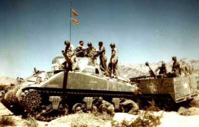
It will take about two years to construct the library, which will be designed in the image of the historical Goffs railroad depot, which operated from 1902 to 1956. In the early 1940s, thousands of soldiers training in desert warfare arrived and departed from the depot, which was demolished in 1956, Casebier said.
The grant to the Mojave Desert Heritage Cultural Association, founded by Casebier and his wife, Jo Ann, in 1993, is one of 13 awarded out of 276 applications for funds through the endowment, supported by Proposition 40.
In 2002, California voters approved the Clean Water, Clean Air, Safe Neighborhood Parks and Coastal Protection Act, known as Proposition 40, to set aside $267 million for historical and cultural resource preservation.
Kevin Starr, California historian emeritus, said the endowment's mission is to document the contributions of the many groups of people who make up California. It also helps Californians to deepen their understanding of the state's history, its present society, and themselves.
"The receipt of this generous grant marks the first time we've gotten support from outside our own membership of about 800 people,' Casebier said. "The bulk of the work at the Goffs Cultural Center ... has been done by volunteers from California, Arizona and Nevada.'
Viewing the upcoming construction project, volunteer Chris Ervin said, "Now the work really begins.'
Among the volumes in the collection at Goffs are originals of official reports of the 1853-54 Whipple expedition, which surveyed a route for a Pacific railroad across the Mojave.
"We also have the official reports and map of Edward Fitzgerald Beale, who brought camels to California from Texas in 1850,' Casebier said.
"The collection includes everything related to the East Mojave, dating to 1850. There was nothing before that.'
Casebier said the center acquired the volumes "one at a time and there is a story behind each one.'
The volumes also include 2,000 loose subject files pertaining to individuals of interest and specific cultural sites. It also contains an extensive collection of old area newspapers, periodicals and pamphlets, and material culled from federal records in the National Archives.
"We also have compiled 700 oral histories,' Casebier said. "We're constantly looking for volunteers to help us continue this important work, and are searching for desert old-timers to participate in our extensive oral history program.'
Casebier, 72, a Kansan who served in the Marine Corps at Twentynine Palms for 22 years, later was employed as a Navy physicist working with guided missile systems in Corona. During visits to Washington, D.C., he frequented the Library of Congress and the National Archives, conducting research on the East Mojave.
After writing a book in 1970 about the Arizona territory, Casebier started Tales of the Mojave Road Publishing Co., which has produced 24 titles. Sixteen were authorized by Casebier.
"In 1980, I started in earnest with the library collection,' he said.
A year later, Casebier formed a volunteer group that continues today, called the Friends of the Mojave Road.
"We worked with the U.S. Bureau of Land Management to develop the Mojave Road and other historic trails into the back country,' he said.
For this work, Casebier and the group received the bureau's highest national award for volunteer service.
Upon retiring in 1990, the Casebiers bought the old Goffs school and 113 acres around it, intent on opening a desert cultural center. Three years later, they helped found the nonprofit, tax-exempt Mojave Desert Heritage Cultural Association to take over the property.
"In 1998, Jo Ann and I deeded the school and the 1-acre school yard to the association, restoring the school to its 1914 condition,' Casebier said. "In 2001, the school was listed on the National Register of Historic Places.'
The Casebiers donated 70 acres of their property to the cultural association in late 2002.
TOPICS: Culture/Society; Extended News; News/Current Events; US: California
KEYWORDS: mohave
Navigation: use the links below to view more comments.
first previous 1-20, 21-35 last
To: Ernest_at_the_Beach
Thanks.
That whole area was part of CAMA, that being the California Arizona Maneuver Area.
General Patton was a hard taskmaster as he know these guys would be facing a tough enemy in North Africa shortly.
God bless them all.
21
posted on
05/30/2005 10:48:43 AM PDT
by
investigateworld
( God bless Poland for giving the world JP II & a Protestant bump for his Sainthood!)
To: All
From the above link:
On August 8, 1940, a Presidential order withdrew from public use almost 1,000 square miles of public land in the High Desert of Southern California. The land was established as the Mojave Anti-Aircraft Gunnery Range and later named Camp Irwin in memory of Major General George Irwin, , commander of the 57th Field Artillery Brigade during World War I. During World War II, Camp Irwin was used for training and served as an internment site for prisoners of war. In 1944, the camp was closed by the War Department and remained in caretaker status until 1951.
22
posted on
05/30/2005 10:50:37 AM PDT
by
Ernest_at_the_Beach
(This tagline no longer operative....floated away in the flood of 2005 ,)
To: investigateworld; lainie
That whole area was part of CAMA, that being the California Arizona Maneuver Area.Would you know the general boundaries of that area....I'll do some googling on CAMA also.
23
posted on
05/30/2005 10:52:53 AM PDT
by
Ernest_at_the_Beach
(This tagline no longer operative....floated away in the flood of 2005 ,)
To: investigateworld
24
posted on
05/30/2005 10:56:14 AM PDT
by
Ernest_at_the_Beach
(This tagline no longer operative....floated away in the flood of 2005 ,)
To: Ernest_at_the_Beach
Historic California Posts
-
California/Arizona Maneuver Area
-
(Desert Training Center)
 This was the largest Army base in the world covering some 18,000 square miles. It stretched from the outskirts of Pomona, California eastward to within 50 miles of Phoenix, Arizona, southward to the suburbs of Yuma, Arizona and northward into the southern tip of Nevada. It existed primarily to train U.S. forces in desert warfare for the North African campaign.
Native Californian Major General George Smith Patton, Jr., commander of the I Armored Corps, was responsible for selecting this site in early 1942. As a native of southern California he knew the area well from his youth and from having participated in Army maneuvers here and in the Mojave Desert in the 1930s. Patton chose the small town of Desert Center, population 19, as his headquarters. At that time the training base was called "Desert Training Center" and had not yet reached it maximum size. Six months later it was given the CAMA name, and by November 1943, it had reached its maximum size after several expansions. Patton and his advanced team designated various locations within the area where tent camps would be built to house individual units. The camps were situated so that each unit could train individually without interfering with the other. Airfields, hospitals, supply depots and sites for other support services were selected as was a corps maneuvering area. The plan was that each division and or major unit would train in its own area, and near the end of its training period would participate in a corps (two divisions or more) exercise in the corps maneuvering area at Palen Pass. Upon completion of the corps exercise, the trained units would leave CAMA, and new units would arrive to begin their training and the process repeated.
The area chosen in the Mojave Desert was ultimately 350 miles wide and 250 miles deep. On 20 June 1942 the War Department acquired the land from the Department of the Interior by Public Land Order No. 1. The area included several sections in Riverside County, ranging from Indio, California to Arizona and from Las Vegas to Yuma. On May 12, 1942, by announcement of General Orders No. 7, the Desert Training Center was named Camp Young. On January 27, 1943, by announcement of General Orders No. 8, Camp Young "proper" (3,279.89 acres) became the Headquarters of the Desert Training Center/California-Arizona Maneuver Area (DTC/CAMA). By November 1943 CAMA had enlarged and included Camp Young, Camp Coxcomb, Camp Iron Mountain, Camp Granite, Camp Essex (later renamed Camp Clipper), Camp Ibis, Camp Hyder, Camp Horn, Camp Laguna, Camp Pilot Knob, Camp Bouse and several bombing and artillery ranges.
CAMA was divided into a Communication Zone and a Combat Zone. The Communications Zone surrounds and entirely encloses the Combat Zone. Those areas within the perimeter of the Communication Zone are not really maneuver areas. Camp Young was located outside the Combat Zone, within the Communication Zone (Desert Area Recreation Survey, Geography of Desert Training Center 1943).
General Patton, who was independently wealthy, purchased some commercial radio broadcasting equipment with his own funds and set up his own radio station within CAMA. The station broadcasted music and news most of the time except when Patton wanted to address the troops. He kept a microphone at his desk and another by his bed and broke into the programming whenever it suited him.
Patton's I Armored Corps trained here from April to August 1942 and then departed to participate in the invasion of North Africa which occurred in November 1942. As Patton and his.troops moved out, the II Armored Corps, under Major General Alvan Gillem, Jr., moved in. They trained at CAMA until October and their place was taken by the IV Armored Corps. They were followed in successive order by the IX Corps, XV Corps, IV Corps and X Corps.
When the Allied victory came in North Africa, the need for desert-trained units faded and in May 1944, CAMA was closed. Most of the sites can be visited, but some are difficult to reach. In most cases the only things that remain at the camp sites are streets, sidewalks, building foundations, patterns of hand-laid rocks for various purposes and trash dumps. Monuments have been erected at some of the camp sites and there are areas within CAMA that are fenced off with danger signs warning of unexploded ordnance. The following is a list of the California elements of CAMA.
-
25
posted on
05/30/2005 10:58:09 AM PDT
by
Ernest_at_the_Beach
(This tagline no longer operative....floated away in the flood of 2005 ,)
To: investigateworld
Wonder if Fort Irwin was even part of this huge area?
26
posted on
05/30/2005 10:59:05 AM PDT
by
Ernest_at_the_Beach
(This tagline no longer operative....floated away in the flood of 2005 ,)
To: Ernest_at_the_Beach
Historic California Posts:
Camp Young *********************************************
World War II's command headquarters for General George S. Patton's huge Desert Training Center, established for the training of troops in desert warfare, was estahlished sometime in 1942. It was located not far south of Indio, Riverside County, near the present junction of U.S. 10 and State Route195, where the Cottonwood Springs Road runs up through the Joshua Tree National Monument.
-
-
History
-
- In early March of 1942 the War Department ordered Major General George Smith Patton, Jr., U.S. Army, to locate, create, equip, and command a desert training center in California to prepare troops to fight the Nazis in North Africa. These Army ground and air forces were to become skilled in desert warfare.
The area chosen in the Mojave Desert was ultimately 350 miles wide and 250 miles deep. On 20 June 1942 the War Department acquired the land from the Department of the Interior by Public Land Order No. 1. The area included several sections in Riverside County, ranging from Indio, California to Arizona and from Las Vegas to Yuma. On May 12, 1942, by announcement of General Orders No. 7, the Desert Training Center was named Camp Young. On January 27, 1943, by announcement of General Orders No. 8, Camp Young "proper" (3,279.89 acres) became the Headquarters of the Desert Training Center/California-Arizona Maneuver Area (DTC/CAMA). By November 1943 CAMA had enlarged and included Camp Young, Camp Coxcomb, Camp Iron Mountain, Camp Granite, Camp Essex (later renamed Camp Clipper), Camp Ibis, Camp Hyder, Camp Horn, Camp Laguna, Camp Pilot Knob, Camp Bouse and several bombing and artillery ranges.-
- CAMA was divided into a Communication Zone and a Combat Zone. The Communications Zone surrounds and entirely encloses the Combat Zone. Those areas within the perimeter of the Communication Zone are not really maneuver areas. Camp Young was located outside the Combat Zone, within the Communication Zone (Desert Area Recreation Survey, Geography of Desert Training Center 1943).
-
- Between 800,000 and 1,000,000 soldiers prepared for warfare at the CAMA. Camp Young was the administrative headquarters and the focal point of the maneuvers area for General Patton's 3rd Armored Division. The overwhelming focus of the training was on tank warfare. Camp Young remained the focal point for the CAMA until the closure of the center in 1944. In January 1943 per General Order No. 9, First Headquarters Special Troops was organized to supervise training and administer non-divisional units, except Field-Artillery, in the desert. Due to the large area of the CAMA, three additional Special Troops Headquarters were created to control and supervise. The 601st Engineer Camouflage Battalion was assigned to Camp Young December 1942. Also, stationed at Camp Young was the IV Corps Command Headquarters. From October 1943 to January 1944 the primary mission of the headquarters transitioned from purely training activities to almost 100% Preparation and Movement of units for Overseas Shipment (POM).
- A series of 13 ranges was constructed south and west of Camp Young. The ranges were designed for small caliber arms and for mortar fire including 37mm, 75mm, and 155mm (Camp Young Range n.d.). Shavers Army Airfield (a small runway) was built east of and adjacent to Camp Young.
-
- Almost all the land acquired for the California - Arizona Maneuver Area was declared surplus by the War Department on 16 March 1944. The land acquired for the Camp Young site was relinquished on 14 January 1947 to the Department of the Interior by Public Land Order No. 342. The Camp Young site consists of 3,279.89 acres.
-
- Known Units at Camp Young:
-
- 252nd Italian Quartermaster Salvage Repair Company.
27
posted on
05/30/2005 11:04:43 AM PDT
by
Ernest_at_the_Beach
(This tagline no longer operative....floated away in the flood of 2005 ,)
To: GVgirl; investigateworld; lainie; Bear_Slayer
Between 800,000 and 1,000,000 soldiers prepared for warfare at the CAMA. Camp Young was the administrative headquarters and the focal point of the maneuvers area for General Patton's 3rd Armored Division. The overwhelming focus of the training was on tank warfare.Just unreal!!!
28
posted on
05/30/2005 11:07:16 AM PDT
by
Ernest_at_the_Beach
(This tagline no longer operative....floated away in the flood of 2005 ,)
To: Ernest_at_the_Beach
Basically yes. But Fort Irwin was a more focused type of training as illustrated by it's initial name: Mojave Anti-aircraft Training Range. It was was called Camp Maar by the locals.
Camp Irwin (gads I knew it by that name long before Fort Irwin) and the CAMA facilities where all supported logistically (everything but bullets) by Camp Ono in San Bernardino. Following the defeat of the Axis forces in North Africa, Camp Ono housed a large contingent of Italian POWS*. They supposedly rioted when they were told they were going home, but I don't buy it. Sump'n else set them off.
*As did the ARMY base at YERMO. Old desert dude trivia LOL !
29
posted on
05/30/2005 11:13:35 AM PDT
by
investigateworld
( God bless Poland for giving the world JP II & a Protestant bump for his Sainthood!)
To: Ernest_at_the_Beach
There ya go. On the drive out, Ft. Irwin is a sight to behold even today.
30
posted on
05/30/2005 11:25:56 AM PDT
by
lainie
To: Ernest_at_the_Beach
That is unreal. I saw a figure somewhere, also, that the largest number of troops at one time was 16,000. That's like a George Lucas movie. :-)
31
posted on
05/30/2005 11:27:35 AM PDT
by
lainie
To: Ernest_at_the_Beach
Just unreal!!! Indeed. Wouldn't it be incredible to see an reenactment?
32
posted on
05/30/2005 11:35:02 AM PDT
by
GVnana
To: Ernest_at_the_Beach
I am a native Californian, we used to go off roading out there all the time. It is quite beautiful - just not in the summer. Thanks for the ghost town links, they will come in handy when we go out there next!
To: investigateworld
34
posted on
05/30/2005 8:50:28 PM PDT
by
Ernest_at_the_Beach
(This tagline no longer operative....floated away in the flood of 2005 ,)
To: Ernest_at_the_Beach; The Right Stuff; lainie
Anyone up for a field trip? This is SO NEAT!!!! Thanks for the links!
35
posted on
05/30/2005 9:19:50 PM PDT
by
Brad’s Gramma
(Yo! Cowboy! I'm praying for a LoganMiracle! It CAN happen!!!!)
Navigation: use the links below to view more comments.
first previous 1-20, 21-35 last
Disclaimer:
Opinions posted on Free Republic are those of the individual
posters and do not necessarily represent the opinion of Free Republic or its
management. All materials posted herein are protected by copyright law and the
exemption for fair use of copyrighted works.
FreeRepublic.com is powered by software copyright 2000-2008 John Robinson