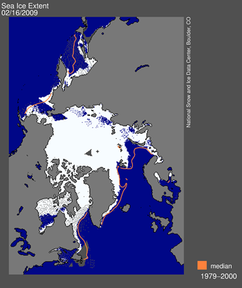
Daily Arctic sea ice extent map for February 15, 2009, showed areas of open water which should have appeared as sea ice.
So, the global warmers who were predicting an ice free north pole during the summer were full of [expletive]. What a surprise?
Posted on 02/19/2009 5:15:35 AM PST by RKV
As some of our readers have already noticed, there was a significant problem with the daily sea ice data images on February 16. The problem arose from a malfunction of the satellite sensor we use for our daily sea ice products. Upon further investigation, we discovered that starting around early January, an error known as sensor drift caused a slowly growing underestimation of Arctic sea ice extent. The underestimation reached approximately 500,000 square kilometers (193,000 square miles) by mid-February. Sensor drift, although infrequent, does occasionally occur and it is one of the things that we account for during quality control measures prior to archiving the data.
(Excerpt) Read more at nsidc.org ...
Translation: AMSR-E data doesn't fit our global warming scare religion, so we ignore it.
Looks like a lot of Artic Sea Ice to me. In fact, it looks like with just a little more accumulation it could slowly become North Atlantic Sea Ice.
You have to understand that if they weren’t full of (expletive), they wouldn’t be full of anything.
It must be that they would not want to admit that the sea ice has improved greatly over the past few years and now is more than in several years of the past.
The NASA climate (we do not know) bunch have lied several times about warming and looks as though they will continue to do so. Especially with the 400 million that they will get from the PORK BILL, to keep their lies in full steam ahead.
In other words, we cannot justify our historical conclusions by using accurate data. SO THERE!!!
This statement by a supposedly scientific organization is an admission of the political nature of their operation. They are basically saying they ignore the truth in order to continue to give a consistent, but inaccurate, measure of arctic ice coverage. There can be only one reason for this, and it is not to better serve the public! What a bunch of charlatans. Whoever runs this organization should be fired immediately and replaced by a real scientist.
AMSR-E???
Someone over at solarcyle24.com keeps and updated AMSR-E graph plotting most recent years
Translation: We had no clue you folks would catch this.
it became clear that there was a significant problem—sea-ice-covered regions were showing up as open ocean.
Translation: If we state the obvious maybe we can get our credibility back.
The problem stemmed from a failure of the sea ice algorithm caused by degradation of one of the DMSP F15 sensor channels.
Translation:If we throw out enough crap maybe you folks will go away. Anyway, we aren't sure if its the algorithm or the data but if we word this carefully enough you folks might not realize we have no clue
Upon further investigation, we found that data quality had begun to degrade over the month preceding the catastrophic failure.
Translation: We might as well get out in front and let you know this isn't the first time.
As a result, our processes underestimated total sea ice extent for the affected period.
Translation: We like the word underestimate better than misled, or recklessly estimated or even negligent.
Based on comparisons with sea ice extent derived from the NASA Earth Observing System Advanced Microwave Scanning Radiometer (EOS AMSR-E) sensor, this underestimation grew from a negligible amount in early January to about 500,000 square kilometers (193,000 square miles) by mid-February (Figure 2).
Translation: You see we really did know what was happening but the numbers we were giving you looked so good we didn't want to spoil the global warmers fun
While dramatic, the underestimated values were not outside of expected variability until Monday, February 16.
Translation: We didn't get caught until February 16.
Although we believe that data prior to early January are reliable, we will conduct a full quality check in the coming days.
Translation: All we are admitting to is 6 weeks of errors. You have to trust us that the other data is good. Really.
Translation: “We crap weasels are unimpressed with data conflicting with our politics.”
Wow! What mind-bending, tortured gobbledygook. I can just imagine telling my bosses in the labs that I wasn't going to use the new, more accurate sensor technology that provides more confidence in the results because it wasn't consistent with my readings using the older, poorer, more inconsistent sensors I've always used. That would go over real well.
Quite a fisking. Well done.
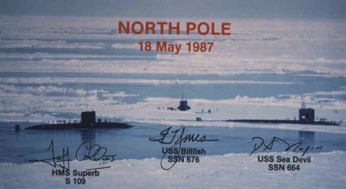
You’ve probably heard of the “little ice age.”
Getting a baseline back to historical records between old and new sensors is a problem. I’ve certainly seen this in industry. That said, you really ought to take the best data, whether or not it’s consistent with historical data.
(bullshit to english translation)
We got caught fudging data and now we have to try to yank our pants up and run away.
But don’t worry daddy algore, we’ll keep lying for you, just let us save face for a few minutes.
Yup, some squeeler is out of a job.
Yeah, I caught that too. Here is further proof they only see what they want to see:
Sensor drift is a perfect but unfortunate example of the problems encountered in near-real-time analysis. We stress, however, that this error in no way changes the scientific conclusions about the long-term decline of Arctic sea ice, ...
Now..... I understand that!
From this Press Release:
NOAA's Environmental Satellite Ground Segment
***********************EXCERPTS**********************
NOAA's (National Oceanic and Atmospheric Administration) next-generation Geostationary Operational Environmental Satellite R series, known as GOES-R.
*********************snip**************************
When launched, GOES-R will deliver significant technological advancements to provide sustained, reliable collection, analysis and distribution of data from the atmosphere, oceans, land and sun.
Disclaimer: Opinions posted on Free Republic are those of the individual posters and do not necessarily represent the opinion of Free Republic or its management. All materials posted herein are protected by copyright law and the exemption for fair use of copyrighted works.