
Posted on 08/26/2009 8:17:50 AM PDT by NautiNurse
Tropical Storm Danny formed in the North Atlantic about 775 miles SSE of Cape Hatteras NC. Tropical storm force winds extend outward up to 140 miles, mainly to the north of the center.

Public Advisories Updated every six hours.
Tropical Storm Discussion Updated every six hours
Statement as of 11:00 am EDT on August 26, 2009
...The area of disturbed weather east of the Bahamas becomes Tropical Storm Danny...
interests in the Bahamas and the southeastern United States should monitor the progress of Danny.
For storm information specific to your area in the United States...including possible inland watches and warnings...please monitor products issued by your local National Weather Service forecast office. For storm information specific to your area outside of the United States...please monitor products issued by your National meteorological service.
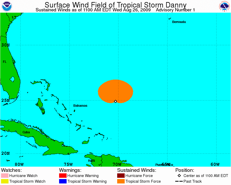
At 1100 am EDT...1500 UTC...the center of Tropical Storm Danny was located near latitude 24.9 north...longitude 70.3 west or about 445 miles...715 km...east of Nassau and about 775 miles...1250 km... south-southeast of Cape Hatteras North Carolina.
Danny is moving toward the west-northwest near 18 mph...30 km/hr. A general northwestward motion with a decrease in forward speed is expected today and Thursday...with a turn toward the north-northwest expected on Friday.
Maximum sustained winds are near 45 mph...75 km/hr...with higher gusts. Slow strengthening is possible during the next couple of days.
Tropical storm force winds extend outward up to 140 miles...220 km mainly to the north of the center.
The minimum central pressure estimated from NOAA hurricane hunter aircraft data is 1009 mb...29.80 inches.
Danny is expected to cause storm total rainfall of 2 to 3 inches... with maximum amounts of 4 inches...over the central and northwestern Bahamas. Storm total rainfall of 1 to 2 inches are expected over the southeastern Bahamas and the Turks and Caicos Islands.
...Summary of 1100 am EDT information... location...24.9n 70.3w maximum sustained winds...45 mph present movement...west-northwest or 295 degrees at 18 mph minimum central pressure...1009 mb
the next advisory will be issued by the National Hurricane Center at 500 PM EDT.
$$ Forecaster Beven

On/Off Hurricane List Mash Here--> 

Tanks for da ping NN.
Wow .. that came up fast. Looks like
my family in New England are gonna feel
some of this guy.
Looks like Florida has dodged another bullet.
Why do you want everyone who is concerned about their lives and property to see that photo? Please find an adult and ask them what they would do in this situation. Your own judgment is impaired.
so, saturday in new york city probably won’t be looking too good, huh?
Are we seeing the beginning of a trend? It looks as though it’s going the way Bob went.
It’s too early to tell yet for the NE coast. Certainly worth watching.
i’ll flying back to NYC from chicago on sunday evening. hopefully everything will be back to normal by then.
It’s starting to look that way.
*******SIGH********
We really Don’t need any more rain..........
There goes my weekend...
I just saw a show on one of the science channels that talked about how primed NYC is for disaster if a hurricane ever hit. Long Island and N.J. form a perfect funnel to aim and concentrate a storm surge right into Manhattan.
Just lovely. I’m heading down to the Outer Banks for vacation on Saturday. *sigh*
you say that like it’s a bad thing
I put this thread into Extended News since the forecast uncertainty covers much of the East Coast. If watches/warnings come up, please go ahead and post the threads into Front Page
sw
Disclaimer: Opinions posted on Free Republic are those of the individual posters and do not necessarily represent the opinion of Free Republic or its management. All materials posted herein are protected by copyright law and the exemption for fair use of copyrighted works.