Posted on 09/05/2011 11:27:31 PM PDT by Cincinatus' Wife
Wildfire Update – Sept. 5, 2011
Current situation:
· Texas Forest Service responded yesterday to 63 new fires that burned 32,936 acres, including 22 new large fires.
· Strong winds and low relative humidity from Tropical Storm Lee caused numerous wildfires to spread rapidly yesterday. Additional National Guard Blackhawk helicopters and Texas Intrastate Fire Mutual Aid System (TIFMAS) strike teams, as well as a heavy airtanker from South Dakota were mobilized Sunday to assist with the large number of fires. Weather conditions are expected to reach critical levels again today.
· Texas Forest Service has dozens of aircraft ready to respond this morning, including four heavy airtankers, 15 single-engine airtankers, 12 helicopters, and 13 aerial supervision aircraft. A Type 1 incident management team has been requested to assist with the Bastrop County Complex.
· 251 of the 254 Texas counties are reporting burn bans.
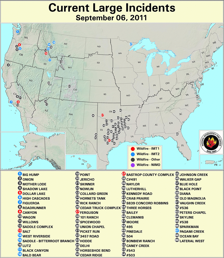
· Daily detailed fire information can be found at inciweb.org.
New large fires from yesterday (more than 100 acres in timber, 300 acres in lighter fuels; or where homes were lost):
* Note: Details on many fires are still unconfirmed. Below is the latest information provided.
BASTROP COUNTY COMPLEX, Bastrop County. 14,000 acres, no containment. Heavy airtankers and single-engine airtankers assisted on this fire that started in the Lost Pines area just northeast of Bastrop. The fire has moved unchecked for at least 16 miles to the south and has jumped the Colorado River twice. The Circle D, K.C. Estates, Pine Forest, Colovista and Tahitian Village subdivision have been evacuated. Firefighters are trying to hold the fire at FM 2571. Reports indicate possibly 300 homes have been destroyed. MODIS satellite image indicates the fire has jumped Highway 95 and is approximately 25,000 acres.
STEINER RANCH, Travis County. 150 acres, no containment. The fire started just north of the Steiner Ranch subdivision. More than 1,000 homes are under mandatory evacuation in Steiner Ranch. At least 25 homes are reported lost. A Texas Intrastate Fire Mutual Aid System strike team responded.
PEDERNALES BEND, Travis County. 7,000 acres, unknown containment. The fire is burning four miles southeast of Spicewood. Twenty homes were lost, 30 homes damaged.
HENDERSON #495, Henderson County. 5,000 acres, unknown containment. Three homes were saved.
#491, Limestone County. 3,000 acres, unknown containment. Six homes were saved and one was lost on this fire 20 miles east of Waco.
DELHI, Caldwell County. 1,000 acres, 10 percent contained. Twenty homes were saved and six were lost on this fire east of Lockhart.
BAILEY, Colorado County. 1,000 acres, unknown containment. This fast-moving fire threatened 40 homes near Columbus. Blackhawks, single-engine airtankers and a heavy airtanker assisted.
MOORE, Smith County. 927 acres, 5 percent contained. Ten homes were evacuated and five were lost on this fire burning on the Smith/Gregg County line. Two civilian fatalities were reported.
#545, Upshur County. 500 acres, 50 percent contained. One hundred homes were saved; none lost. The fire is burning East of Gilmer.
LUTHERHILL, Fayette County. 2,000 acres, unknown containment. The community of Ruttersville was evacuated. Seven homes are reported lost.
BONBIEW RANCH, Van Zandt County. 350 acres, unknown containment. Twenty homes were saved southeast of Canton.
CLEMANIS, Upshur County. 400 acres, 85 percent contained. Twenty homes were saved.
#543, Gregg County. 300 acres, unknown containment. Numerous homes were saved, none lost.
#538, Harrison County. 200 acres, contained. One hundred fifty homes were evacuated in a trailer park east of Longview.
#502, Nacogdoches County. 200 acres, unknown containment. More than a dozen homes have been evacuated, but none lost.
#841, Houston County. 200 acres, unknown containment. Fifteen homes were threatened east of Crockett.
PLEASANT GREEN ROAD, Gregg County. 150 acres, contained. Numerous homes evacuated and saved south of Longview.
KENNEDY ROAD, Rusk County. 150 acres, unknown containment. Numerous homes threatened, one lost.
HODDE, Travis County. 325 acres, contained. Two hundred homes were evacuated and saved east of Pflugerville. No homes reported lost.
PETTYTOWN, Caldwell County. 200 acres, 90 percent contained. Twenty homes were saved east of Lockhart.
OLD MAGNOLIA, Gregg County. 100 acres, unknown containment. No homes threatened. Two fuel tanks exploded.
SOUTH SULPHER, Hunt County. 100 acres, 70 percent contained. Five homes were threatened and two were destroyed.
#839, Leon County (Concord Robbins). 100 acres, unknown containment. At least 15 homes are reported lost and more than 300 were evacuated.
Uncontained fires from previous days (more than 100 acres in timber, 300 acres in lighter fuels):
*Note: No current updates available except on the 101 Ranch Fire.
101 RANCH, Palo Pinto County. 6,555 acres, 75 percent contained. The fire is burning on the south side of Possum Kingdom Lake near the town of Brad. Thirty-nine homes and nine RVs have been reported destroyed.
CRAB PRAIRIE, Walker County. 977 acres, 90 percent contained. Numerous SEATs and helicopters, as well as National Guard bulldozers assisted. Two homes were reported to be lost.
HORNETS TANK, Briscoe County. 5,500 acres, 90 percent contained. The fire is burning in juniper and grass in rough terrain near Palo Duro Canyon.
CEDAR RIDGE, Bosque County. 903 acres, 75 percent contained.
3547 ROAD, Wise County. 400 acres, 80 percent contained. Approximately 60 homes were evacuated near this fast-moving fire. Five homes were lost.
JOHNSON (JACKSON) RANCH, Edwards County. 600 acres, 95 percent contained. Three homes were lost on this fire burning 27 miles northwest of Hunt.
BIG DRAW, Kimble County. 600 acres, 20 percent contained. Active fire behavior in heavy fuels and steep terrain was observed. Twenty homes are threatened.
RICK RANCH, Sutton County. 395 acres, 95 percent contained. The fire is burning 24 miles west of Junction.
JACK MOUNTAIN, Coryell County. 1,700 acres, 60 percent contained. The fire is burning five miles south of Gatesville on the Ft. Hood military reservation.
BUNDY ROSS RANCH, Edwards County. 600 acres, 75 percent contained. The fire is burning in juniper, grass and brush 7 miles southeast of Telegraph.
DOUBLE T, Menard County. 300 acres, 95 percent contained. The fire is burning 19 miles west of Brady.
PICKET RUN, Montague County. 1,100 acres, 90 percent contained. The fire is burning in tall grass 7 miles south of Bowie.
CEDAR TRUCK COMPLEX, Kimble County. 357 acres, 80 percent contained. Thirteen homes were saved on this fire burning just west of Fort McKavett. This was a combination of 34 different starts along a 24-mile stretch of highway.
COSTER, Hall County. 1,000 acres, 80 percent contained. Four homes were saved on this fire burning 26 miles northwest of Childress.
HORSESHOE BEND, Coryell County. 525 acres, 75 percent contained. The fire is burning 10 miles south of McGregor. National Guard Blackhawks assisted on the fire. Twelve homes were saved.
Weather Outlook:
A ridge of dry high pressure across the mid U.S. and the Texas panhandle will drift into west Central Texas during the day. This will continue the stronger winds over the east half or more of the state along with drier relative humidities into the 10 to 20 percent range across much of the state. High temperatures will be in the upper 70s to lower 80s over a large portion of North Texas to near 100 over Deep South Texas near the Mexico border. The stronger winds are expected to weaken over most of the state Monday night.
http://www.statesman.com/news/local/
http://www.statesman.com/news/local/2-bodies-found-in-bastrop-fires-leander-fire-1824552.html
http://www.statesman.com/news/local/fires-destroy-hundreds-of-homes-1821845.html
http://www.chron.com/news/gallery/Magnolia-fire-from-the-air-30713/photo-1578871.php
More on magnolia fire and Montgomery, Waller and Grimes (closer to Houston)
http://www.chron.com/news/gallery/Magnolia-fire-from-the-air-30713/photo-1578871.php
BARACK OBAMA HATES TEXAS!
OBAMA’S KATRINA? The only reason it isn’t viewed that way is because Texas is a red state and can take care if itself, but where’s the federal response? Perry should mention that in the debate tomorrow! Where’s the MSM?
I am counting over 50 fires in close proximity. CW, where are you? Are you somewhere safe?
I’m good. I’m in the Houston metroplex area — dry as a popcorn fart but no fires.
Thank you for the link to the fire graphic.
You safe?
I am under a freaking floodwatch. I wish I could send you all this.
Seriously though, look at the map there. Notice how the center of these fires is almost a perfect circle? Bastrop, South, College Station, East, Pflugerville, West, and Mart, North. Perfect circle.
This is what the fires in Greece looked like.
We sure would be glad to take it off your hands!
Another visual on fire pattern and distribution here:
http://ticc.tamu.edu/Response/FireActivity/
Thank you for the map. Got to try and get some sleep now. Stay safe. Prayers for you before I sleep. G-d Bless Texas.
I’ve thought of this, too! He hates Texas and Texans so much, that I wouldn’t put it past him or his goons.
The first thing I noticed when I took the dog out this morning (besides the cool temps) was the smell of smoke hanging in the air. We’re in NW Cass County - the fires are all around.
There have at least two cases where fires were deliberately set in the area.
It will take some time to do the investigation but, I suspect they will be other cases of foul play found..
Good morning. Checking in. Not much has changed since I wenr ro sleep, I guess. I’ve been trying to find out if obama has finally issued an emergency declaration for Texas. Can’t seem to find anything definitive. Has he or hasn’t he?
Disclaimer: Opinions posted on Free Republic are those of the individual posters and do not necessarily represent the opinion of Free Republic or its management. All materials posted herein are protected by copyright law and the exemption for fair use of copyrighted works.