click to enlarge
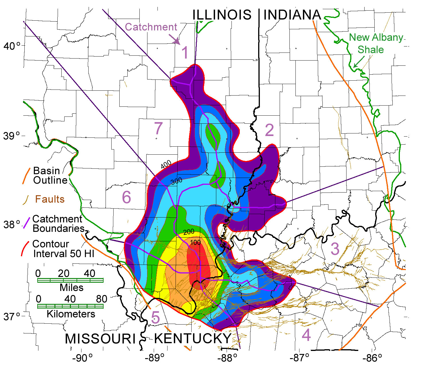
Figure 5. Decreasing hydrogen index (HI) contours show regions of increasing thermal maturity of New Albany Shale source rocks within the Illinois Basin. Contour interval is 50 HI. The 400 HI contour (red line) outlines the area of source rocks that are thermally mature for oil generation. Catchments are labeled clockwise from 1 to 7. Irregular dark-green line outlines the maximum extent of the New Albany Shale (modified from Lewan and others, 1995, 2002).

Figure 7. Generalized stratigraphic column of Devonian and Mississippian strata in the southern part of the Illinois Basin. Horizontal red lines to the right of the column indicate the primary oil and gas productive intervals. Shown are names and vertical and lateral associations of strata from Late Devonian to Late Mississippian time. The New Albany Shale hydrocarbon source rock is also labeled (Modified from Bell and others, 1961; Buschbach and Kolata, 1991, reprinted by permission of The American Association of Petroleum Geologists and AAPG Data Systems (Datapages, Inc.)
click to enlarge
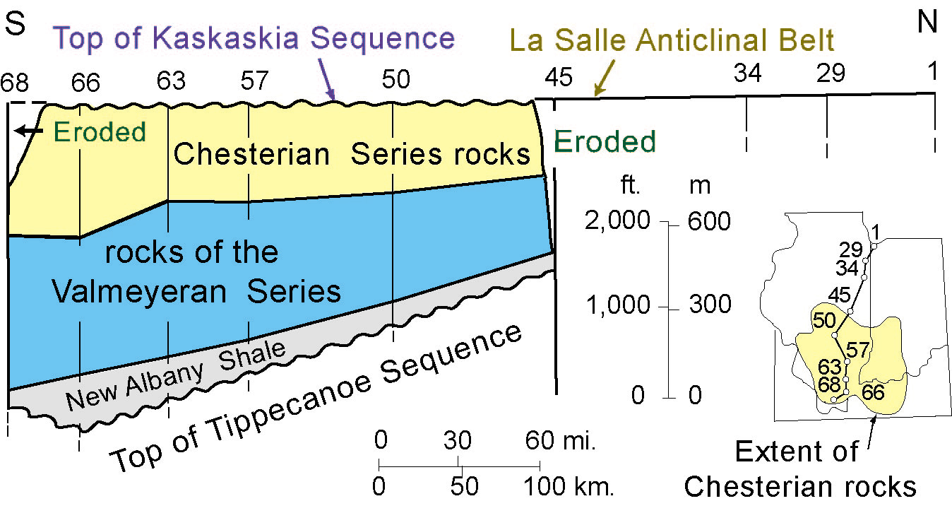
Figure 8. This generalized southwest-northeast stratigraphic cross section of the Middle Devonian through Mississippian Kaskaskia sequence shows vertical and lateral extent of primary hydrocarbon source rock and reservoir rocks in the Illinois Basin (modified from Treworgy and Devera, 1991
Petroleum Production in the Basin
The Clark County Division field was drilled in the Illinois Basin in 1900; this is the first field that contains discovery date information in the PI/Dwights databases (1996, 1999) and Nehring database (1996).Average discovery date is 1946 for 320 fields in the databases that contain this information. The Illinois Basin has a mature exploration status. Macke (1996) estimated that 10 or fewer oil accumulations of 1 million barrels or greater remain to be discovered in Mississippian and Pennsylvanian formations in the basin and that remaining reserve growth will mainly result from secondary and tertiary methods of petroleum production from existing fields.The basin contains more than sixty different petroleum pay intervals that range in age from Ordovician to Pennsylvanian; production is primarily from structural traps at depths of less than 5,500 ft (1,675 m) (Howard and Whitaker, 1990). "A number of hydrocarbon occurrences are closely related to the tops of three major carbonate intervals"; these are listed by Howard (1991) as being the Upper Ordovician Ottowa Supergroup, the Silurian and Devonian Hunton Supergroup, and the Mississippian Valmeyeran Series. Most hydrocarbon production in the basin has been from siliciclastic intervals in Chesterian and Pennsylvanian rocks (Howard, 1991). Oltz and others (1991) determined that the Illinois Basin has almost 1,700 fields; these produce mainly oil from about 7,000 separate sandstone and carbonate reservoirs. Ninety-six percent of this production is stripper, or less than 10 BO/day per well; this percentage is six times greater than the national average for stripper production (Oltz and others, 1991). Organic geochemical correlations indicate that more than 99% of discovered petroleum in the basin was derived from the New Albany Shale (Hatch and others, 1991).
Almost 90,000 wells have been drilled in the Illinois Basin; 42%, or about 38,000 wells, are currently listed as oil and (or) gas productive (PI/Dwights WHCS data through Dec, 1996). Total number of dry holes across the basin is 47,800 (PI/Dwights WHCS database through 1996).Figure 4 shows distribution of oil and gas wells across the basin. Production is from Silurian-through Pennsylvanian-age reservoirs.
THE NEW ALBANY SHALE PETROLEUM SYSTEM, ILLINOIS BASIN – DATA AND MAP IMAGE ARCHIVE FROM THE MATERIAL-BALANCE ASSESSMENT
http://pubs.usgs.gov/of/2003/ofr-03-037/htmltext/introduc.htm#DistOGD