Free Republic
Browse · Search
News/Activism
Topics · Post Article

Skip to comments.

PDS (Particularly Dangerous Situation) Tornado Watch - Arkanasas
NOAA ^

Posted on 04/27/2014 2:08:00 PM PDT by dirtboy

URGENT - IMMEDIATE BROADCAST REQUESTED TORNADO WATCH NUMBER 100 NWS STORM PREDICTION CENTER NORMAN OK 335 PM CDT SUN APR 27 2014

THE NWS STORM PREDICTION CENTER HAS ISSUED A

* TORNADO WATCH FOR PORTIONS OF SOUTHWEST AND CENTRAL ARKANSAS EXTREME SOUTHEAST OKLAHOMA

* EFFECTIVE THIS SUNDAY AFTERNOON AND EVENING FROM 335 PM UNTIL 1100 PM CDT.

...THIS IS A PARTICULARLY DANGEROUS SITUATION...

* PRIMARY THREATS INCLUDE... NUMEROUS TORNADOES EXPECTED WITH A FEW INTENSE TORNADOES LIKELY WIDESPREAD LARGE HAIL AND ISOLATED VERY LARGE HAIL EVENTS TO 2.5 INCHES IN DIAMETER LIKELY SCATTERED DAMAGING WINDS AND ISOLATED SIGNIFICANT GUSTS TO 80 MPH POSSIBLE

THE TORNADO WATCH AREA IS APPROXIMATELY ALONG AND 65 STATUTE MILES NORTH AND SOUTH OF A LINE FROM 30 MILES NORTH OF DE QUEEN ARKANSAS TO 50 MILES EAST NORTHEAST OF PINE BLUFF ARKANSAS. FOR A COMPLETE DEPICTION OF THE WATCH SEE THE ASSOCIATED WATCH OUTLINE UPDATE (WOUS64 KWNS WOU0).

PRECAUTIONARY/PREPAREDNESS ACTIONS...

REMEMBER...A TORNADO WATCH MEANS CONDITIONS ARE FAVORABLE FOR TORNADOES AND SEVERE THUNDERSTORMS IN AND CLOSE TO THE WATCH AREA. PERSONS IN THESE AREAS SHOULD BE ON THE LOOKOUT FOR THREATENING WEATHER CONDITIONS AND LISTEN FOR LATER STATEMENTS AND POSSIBLE WARNINGS.

&&

OTHER WATCH INFORMATION...CONTINUE...WW 95...WW 96...WW 97...WW 98...WW 99...

DISCUSSION...DISCRETE STORMS ARE BEGINNING TO DEVELOP ALONG THE DRYLINE NEAR THE RED RIVER IN SE OK...WHILE OTHER CONVECTION IS EXPECTED TO DEVELOP FARTHER S IN NE TX THE REMAINDER OF THE AFTERNOON. THESE STORMS WILL MOVE ENEWD INTO THE WARM SECTOR AND MATURE...AND WILL ENCOUNTER AN INCREASINGLY FAVORABLE ENVIRONMENT FOR TORNADOES IN AR. LOW-LEVEL SHEAR IS VERY STRONG ALONG A RESIDUAL OUTFLOW BOUNDARY ACROSS CENTRAL AR...AND THE LOW LEVELS WILL SLOWLY WARM AND MOISTEN IN THE WAKE OF EARLIER CONVECTION. DISCRETE SUPERCELLS MOVING INTO THIS ENVIRONMENT WILL HAVE THE POTENTIAL TO PRODUCE LONG TRACK...STRONG/VIOLENT TORNADOES WELL INTO THE EVENING.

AVIATION...TORNADOES AND A FEW SEVERE THUNDERSTORMS WITH HAIL SURFACE AND ALOFT TO 2.5 INCHES. EXTREME TURBULENCE AND SURFACE WIND GUSTS TO 70 KNOTS. A FEW CUMULONIMBI WITH MAXIMUM TOPS TO 550. MEAN STORM MOTION VECTOR 24035.


TOPICS: US: Arkansas
KEYWORDS: pds
Navigation: use the links below to view more comments.
first previous 1-2021-4041-6061-80 ... 101-118 next last
To: AceMineral

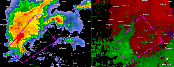
Damage being reported now with a confirmed tornado...


41 posted on 04/27/2014 5:15:07 PM PDT by halo66
[ Post Reply | Private Reply | To 35 | View Replies]

To: halo66

ARC045-105-119-125-280030-
/O.CON.KLZK.TO.W.0008.000000T0000Z-140428T0030Z/
FAULKNER AR-PERRY AR-PULASKI AR-SALINE AR-
714 PM CDT SUN APR 27 2014

...TORNADO EMERGENCY FOR MAUMELLE...

...A TORNADO WARNING REMAINS IN EFFECT FOR NORTH CENTRAL SALINE...
WEST CENTRAL PULASKI...EAST CENTRAL PERRY AND SOUTHWESTERN FAULKNER
COUNTIES UNTIL 730 PM CDT...

AT 710 PM CDT...STORM SPOTTERS AND NATIONAL WEATHER SERVICE
METEOROLOGISTS WERE TRACKING A CONFIRMED TORNADO WITH REPORTS OF
DAMAGE. THIS POTENTIALLY DEADLY TORNADO WAS LOCATED 5 MILES
SOUTHWEST OF LAKE MAUMELLE...MOVING NORTHEAST AT 45 MPH.

THIS IS A TORNADO EMERGENCY FOR MAUMELLE!. TAKE COVER NOW.


42 posted on 04/27/2014 5:15:40 PM PDT by halo66
[ Post Reply | Private Reply | To 41 | View Replies]

To: halo66

pic.twitter.com/dYVCq9FhVu


43 posted on 04/27/2014 5:16:18 PM PDT by halo66
[ Post Reply | Private Reply | To 42 | View Replies]

To: halo66
Per spotters: Debris ball and strong rotational couplet on supercell just to the NW of Little Rock. Damaging tornado in progress.


44 posted on 04/27/2014 5:19:58 PM PDT by grimalkin (We are a nation under God. If we ever forget this, we are a nation gone under. -Ronald Reagan)
[ Post Reply | Private Reply | To 42 | View Replies]

To: grimalkin

tracking it...thanks


45 posted on 04/27/2014 5:24:05 PM PDT by halo66
[ Post Reply | Private Reply | To 44 | View Replies]

To: grimalkin

https://twitter.com/severestudios/status/460575287894630401/photo/1


46 posted on 04/27/2014 5:24:44 PM PDT by halo66
[ Post Reply | Private Reply | To 44 | View Replies]

To: grimalkin
NWS Little Rock ‏@NWSLittleRock 1m HAM OPERATORS ARE REPORTING A TORNADO ON THE SOUTH SIDE OF THE ARKANSAS RIVER, ACROSS FROM PALARM #arwx
47 posted on 04/27/2014 5:25:09 PM PDT by halo66
[ Post Reply | Private Reply | To 44 | View Replies]

To: halo66
NWS Little Rock ‏@NWSLittleRock 47s HAM RADIO OPERATORS ARE REPORTING A TORNADO ON THE GROUND AT ROLAND AS OF 7:24 PM. #arwx
48 posted on 04/27/2014 5:25:52 PM PDT by halo66
[ Post Reply | Private Reply | To 47 | View Replies]

To: halo66
Jeff Piotrowski ‏@Jeff_Piotrowski 1m Mile wide Large destructive tornado coming into Mayflower AR SSW.#ARWX
49 posted on 04/27/2014 5:28:03 PM PDT by halo66
[ Post Reply | Private Reply | To 48 | View Replies]

To: grimalkin
Sean Casey ‏@SeanCaseyImax 49s Massive wedge east of mayflower!
50 posted on 04/27/2014 5:38:16 PM PDT by halo66
[ Post Reply | Private Reply | To 44 | View Replies]

To: grimalkin
ChaserTV ‏@ChaserTV 19s RT @ChadGarneau: Feed shows large tornado on the ground looking NW of Maumelle, AR. #arwx pic.twitter.com/vKNryFku2e
51 posted on 04/27/2014 5:38:51 PM PDT by halo66
[ Post Reply | Private Reply | To 44 | View Replies]

To: grimalkin
Jeff Piotrowski ‏@Jeff_Piotrowski 1m Large very destructive tornado has hit mayflower area lots of damage being reported.#arwx
52 posted on 04/27/2014 5:39:09 PM PDT by halo66
[ Post Reply | Private Reply | To 44 | View Replies]

To: grimalkin
The Storm Report ‏@thestormreport 36s Spotter Network: Brett Adair reports 2 miles SSW of Mayflower, AR; significant damage. Search and rescue underway.
53 posted on 04/27/2014 5:39:54 PM PDT by halo66
[ Post Reply | Private Reply | To 44 | View Replies]

To: halo66
PzFeed Top News ‏@PzFeed 17s BREAKING NEWS: Power flashes and buildings destroyed after massive tornado half mile wide ripped through in Mayflower, AR.
54 posted on 04/27/2014 5:40:04 PM PDT by Sarah Barracuda
[ Post Reply | Private Reply | To 33 | View Replies]

To: grimalkin
NWS Little Rock ‏@NWSLittleRock 38s STATE POLICE HAVE MULTIPLE CALLS REGARDING 18-WHEELERS OVERTURNED ON INTERSTATE 40 NEAR SOUTHERN END OF LAKE CONWAY. #arwx
55 posted on 04/27/2014 5:40:11 PM PDT by halo66
[ Post Reply | Private Reply | To 44 | View Replies]

To: Sarah Barracuda
NWS Little Rock ‏@NWSLittleRock 34s WE HAVE RECEIVED A REPORT THAT GAME AND FISH HEADQUARTERS EAST OF MAYFLOWER HAS BEEN DESTROYED. #arwx
56 posted on 04/27/2014 5:41:27 PM PDT by halo66
[ Post Reply | Private Reply | To 54 | View Replies]

To: Sarah Barracuda

https://twitter.com/nlrweatherman/status/460578981410906113/photo/1


57 posted on 04/27/2014 5:43:07 PM PDT by halo66
[ Post Reply | Private Reply | To 54 | View Replies]

To: Sarah Barracuda

https://twitter.com/wankelrx/status/460579087166103552/photo/1


58 posted on 04/27/2014 5:44:35 PM PDT by halo66
[ Post Reply | Private Reply | To 54 | View Replies]

To: halo66

Just darn.


59 posted on 04/27/2014 5:45:37 PM PDT by Cringing Negativism Network (http://www.census.gov/foreign-trade/balance/c5700.html#2013)
[ Post Reply | Private Reply | To 57 | View Replies]

To: Cringing Negativism Network

Yep...


60 posted on 04/27/2014 5:46:37 PM PDT by halo66
[ Post Reply | Private Reply | To 59 | View Replies]


Navigation: use the links below to view more comments.
first previous 1-2021-4041-6061-80 ... 101-118 next last

Disclaimer: Opinions posted on Free Republic are those of the individual posters and do not necessarily represent the opinion of Free Republic or its management. All materials posted herein are protected by copyright law and the exemption for fair use of copyrighted works.

Free Republic
Browse · Search
News/Activism
Topics · Post Article

FreeRepublic, LLC, PO BOX 9771, FRESNO, CA 93794
FreeRepublic.com is powered by software copyright 2000-2008 John Robinson