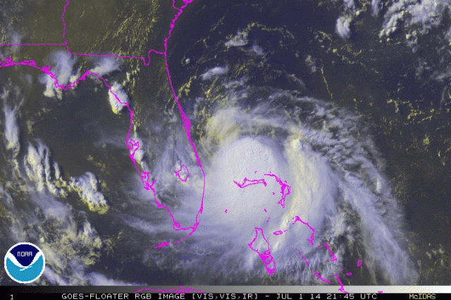
Posted on 07/01/2014 8:16:00 AM PDT by Pyro7480
Awful Arthur is coming. New York should evacuate NOW! There might be....rain, and wind!!
Well, in the case of Chicago, yes... ;-)
If this thing keeps drifting west it’s going to be on my doorstep soon.
It was you? That’s a relief. I was told, to the horror of mecaccompanying children, that I was causing this. The checkout woman at whole foods told me so when I confessed I didnt bring my bags from home
Well, the kids weren’t that horrified. They told me I was wrong for not going the the checkout lined manned by the guy. They tell me the guys don’t care
How do libs explain?
Like they do everything. They get into rage status and hug and puff and tel you you’re stupid
“1st named storm of the Atlantic season”
Which means that it’ll be the first storm blamed on global warming, uh, I mean “climate change”.
it will be labeled “super storm Arthur” because it will cause a drizzle and a cloudy day.
and it will be GWBush’s fault.
Be on your toes Outer Banks. Forecasted winds up to 90MPH and likely to go higher.
000
WTNT41 KNHC 012053
TCDAT1
TROPICAL STORM ARTHUR DISCUSSION NUMBER 4
NWS NATIONAL HURRICANE CENTER MIAMI FL AL012014
500 PM EDT TUE JUL 01 2014
Although radar and satellite imagery indicate that the convective
pattern of Arthur has changed little since the previous advisory...
an Air Force Reserve reconnaissance aircraft investigating the
cyclone this afternoon has found that flight-level and SFMR surface
winds in the southeastern quadrant that support increasing the
intensity to 45 kt. In fact, the flight crew has been been bounced
around pretty good by strong thunderstorms in that area and have
been forced to climb to a higher altitude in order to avoid
significant turbulence.
Arthur has been drifting northwestward at 325/02 kt. No significant
change has been made to the previous forecast track or reasoning.
The latest reliable numerical models remain in good agreement on
large mid-level trough digging southeastward into the northeastern
and mid-Atlantic states during the next 72 hours, while a
subtropical ridge east of the Carolinas gradually strengthens. The
combination of these two systems is expected to steadily increase
the southwesterly steering flow over the southeastern United States
and the extreme western Atlantic. By Days 4 and 5, Arthur is
forecast to accelerate rapidly northeastward ahead of the
aforementioned trough as an extratropical cyclone. The official
forecast track is again just an update of the previous advisory
track, and remains in the middle of the tightly packed guidance
envelope and close to the consensus model TVCA.
Northwesterly vertical wind shear is expected to gradually abate
over the next 48 hours, allowing Arthur to develop an upper-level
outflow pattern that is conducive to strengthening. The primary
inhibiting factor will be the occasional intrusions of dry mid-level
air to the north of the cyclone penetrating into the center and
briefly disrupting the inner-core convection. However, the global
and regional models are forecasting the inner core region to
moisten significantly by 36-48 hours, which should allow Arthur to
strengthen into a hurricane while the cyclone is over warm SSTs and
in light shear conditions. After 72 hours, Arthur will be be moving
over cooler water and is forecast to experience vertical wind shear
in excess of 30 kt, which should induce at least steady weakening.
The NHC intensity forecast closely follows the consensus model IVCN.
FORECAST POSITIONS AND MAX WINDS
INIT 01/2100Z 27.8N 79.4W 45 KT 50 MPH
12H 02/0600Z 28.3N 79.4W 50 KT 60 MPH
24H 02/1800Z 29.2N 79.5W 55 KT 65 MPH
36H 03/0600Z 30.4N 79.2W 60 KT 70 MPH
48H 03/1800Z 32.1N 78.3W 70 KT 80 MPH
72H 04/1800Z 36.6N 73.6W 80 KT 90 MPH
96H 05/1800Z 42.2N 65.5W 60 KT 70 MPH...POST-TROP/EXTRATROP
120H 06/1800Z 46.8N 57.5W 45 KT 50 MPH...POST-TROP/EXTRATROP
$$
Forecaster Stewar

Yes. Even though liberals usually disagree, I'm not stupid.
Amazing light show going on over the Atlantic right now off the east coast of PB County. Just constant lightning w/ no thunder. Very cool.
You mean "climate disruption" - geez! So 2012!

11PM Discussion:
000
WTNT41 KNHC 020252
TCDAT1
TROPICAL STORM ARTHUR DISCUSSION NUMBER 5
NWS NATIONAL HURRICANE CENTER MIAMI FL AL012014
1100 PM EDT TUE JUL 01 2014
Data from the Melbourne WSR-88D radar indicates that Arthur has a
complex structure this evening. A mid-level cyclonic circulation
accompanied by a possible eye feature is clearly evident near 27.8N
78.8W. However, the motions of the light showers/low clouds seen in
the radar data suggest that the low-level center is about 25-30 n mi
west of the mid-level center. Air Force Reserve and NOAA Hurricane
Hunter aircraft are scheduled to investigate Arthur early Wednesday
morning to see if the center has re-formed to the east. Pending the
arrival of the aircraft, the initial intensity remains 45 kt.
The initial motion is a rather uncertain 360/2. The track guidance
models remain in good agreement on a large mid/upper-level trough
digging southeastward into the northeastern and mid-Atlantic states
during the next 72 hours, while a subtropical ridge east of the
Carolinas gradually strengthens. The combination of these two
systems is expected steer Arthur generally northward for 24 hours or
so, followed by a turn toward the northeast and gradual
acceleration. The combination of the lack of motion over the past
6-12 hours and the slightly more eastward initial position have
resulted in some eastward shift of the track guidance envelope. As
a result, the new forecast track is also shifted slightly to the
east from the previous forecast. The official forecast is near the
center of the track guidance envelope and remains close to the
various consensus models.
Arthur is expected to be in an environment of light northwesterly
vertical wind shear for the next 60-72 hours. This should allow for
continued development. However, satellite total precipitable water
data suggests that pockets of dry air remain near the cyclone, and
these could hinder development. Given these competing factors, the
new intensity forecast is changed little from the previous forecast
and calls for Arthur to become a hurricane in about 36 hours and
reach its peak intensity in about 72 hours. After that time, the
cyclone should undergo extratropical transition and weaken as it
merges with the mid/upper-level trough.
Based on the new forecast track, additional watches and warnings
are not necessary for the North Carolina and South Carolina coasts
at this time. However, tropical storm or hurricane watches will
likely be required for portions of these areas on Wednesday.
FORECAST POSITIONS AND MAX WINDS
INIT 02/0300Z 27.9N 79.2W 45 KT 50 MPH
12H 02/1200Z 28.6N 79.3W 50 KT 60 MPH
24H 03/0000Z 29.7N 79.2W 60 KT 70 MPH
36H 03/1200Z 31.0N 78.7W 65 KT 75 MPH
48H 04/0000Z 32.8N 77.3W 75 KT 85 MPH
72H 05/0000Z 37.5N 72.0W 80 KT 90 MPH
96H 06/0000Z 43.0N 64.0W 60 KT 70 MPH...POST-TROP/EXTRATROP
120H 07/0000Z 47.5N 57.0W 45 KT 50 MPH...POST-TROP/EXTRATROP
$$
Forecaster Beven


Disclaimer: Opinions posted on Free Republic are those of the individual posters and do not necessarily represent the opinion of Free Republic or its management. All materials posted herein are protected by copyright law and the exemption for fair use of copyrighted works.