1) if my memory is correct the flow was at 50,000 cfs and in the process of ramping it up to 70,000 when the first pieces started to fly off
2) I’m not sure. But I don’t know what the “bedrock” is and I don’t think they do either. It looks to me the flow cut a channel into the “bedrock” on the right side and was getting deeper each day. So even the “bedrock” can still be eroded away over time
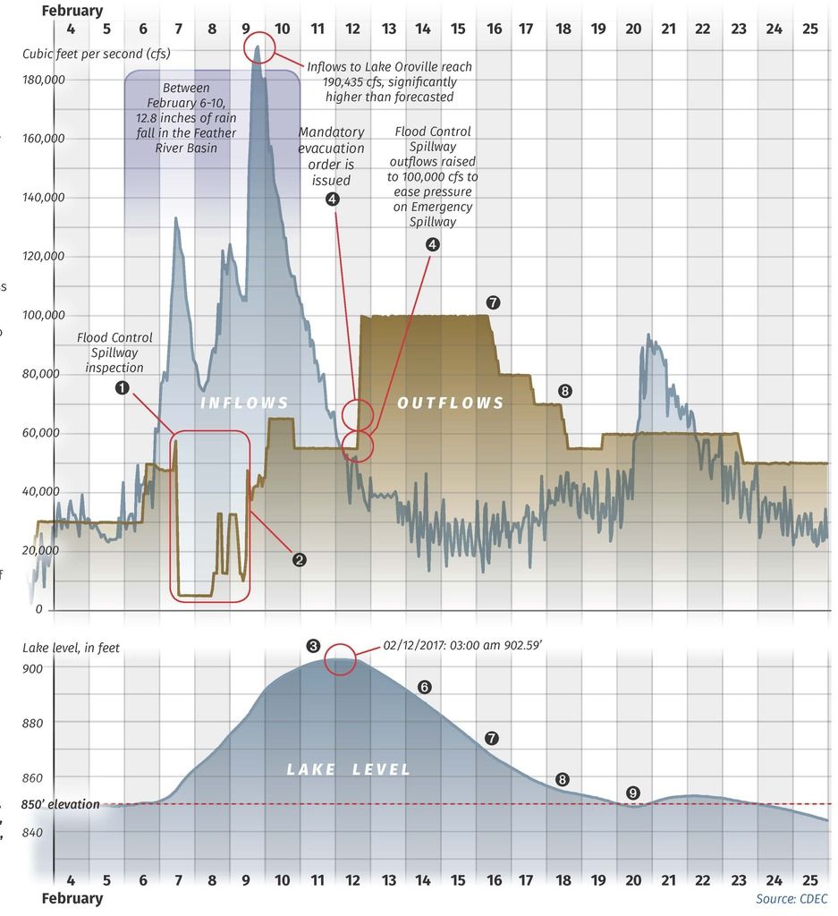
They did go to 100,000 after the “emergency” spillway erosion issue took place, just to get the water levels down in the lake (they were at 901 feet, the spillover level for the emergency weir). But it’s been to 150,000 in past years. I remember seeing a chart that showed that it could (or should have been able to) pass over 250,000 with the gates wide open, but that there were concerns downstream with flooding and overburdening dams further down.
In its damaged state, 50,000 was quoted as the max and 40,000 was considered the minimum sustainable level. At more than 50,000, they were concerned with additional damage, and at under 40,000, the water spill off the end of the spillway would be too vertical and would tend to undermine the end of the spillway.
I had thought that they were going to lay down a hardened, sloping surface at the end of the remaining spillway to allow lower flows, but they did not do that. They, instead, will run it in the 40-50,000 range for a few days, then shut it down for a few weeks and rely on the power plant to pass water downstream. In the press briefing, they said that there would be roughly 3 major releases to accommodate the spring melt, after which the Hyatt power plant in the dam could maintain flows adequately.
Bedrock is essentially that blue/gray rock that you see exposed. It is much harder than the looser brownish rock above it, and makes a pretty sturdy stream bed. It is at the bottom of the “plunge pool” where the spillway dumps water down, and provides a path all the way down to the river. Most of the softer dirt and rock has been scrubbed away from that path already, and was what made up the bulk of the debris pile they cleaned out of the river over the last couple of weeks.
http://www.water.ca.gov/oroville-spillway/pdf/2017/Lake%20Oroville%20events%20timeline.pdf
February 7: As water releases from the flood control spillway ramp up to 54,500 cubic feet per second (cfs), in anticipation of inflows expected from rainfall, DWR employees notice an unusual flow pattern. Spillway flows stop for investigation. Engineers find large area of concrete erosion.