Ongoing event. Multiple confirmed touchdowns. Numerous trained spotter and radar indicated tornadoes ongoing. Multiple low topped supercell events in progress.
Navigation: use the links below to view more comments.
first 1-20, 21-25 next last
To: Milwaukee_Guy
Man,Stay Safe!
2 posted on
04/20/2004 6:18:44 PM PDT by
cmsgop
( "I'm Sick, You're Sick, Were All Sick Of Gorelick !Well said sir!)
To: Milwaukee_Guy
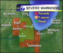
I see two discrete supercells on NWS radar. Mesocyclones near Wheaton Illinois and one near Joliet Illinois.
4 posted on
04/20/2004 6:20:23 PM PDT by
Milwaukee_Guy
(The Law of Unintended Consequences - No Good Deed Shall Go Unpunished!)
To: Milwaukee_Guy
Sirens going in Oak Park.
6 posted on
04/20/2004 6:21:45 PM PDT by
Snake65
(Osama Bin Decomposing)
To: Milwaukee_Guy
Now they've spread the warning into Cook. Rain delay in the White Sox-Yankees game on the south side. Calm for now in the northern burbs of Chicago.
To: Milwaukee_Guy
Oh no, the godless tornadoes!
9 posted on
04/20/2004 6:23:55 PM PDT by
Jeff Chandler
(Why the long face, John?)
To: Milwaukee_Guy
Walgreens in Joliet taken out by tornado according to CLTV (Chicagoland Television).
10 posted on
04/20/2004 6:25:07 PM PDT by
Snake65
(Osama Bin Decomposing)
To: Milwaukee_Guy
It's about time. What good is tornado season without some tornados?
12 posted on
04/20/2004 6:26:39 PM PDT by
HAL9000
To: Milwaukee_Guy
I don't know if this will work, but if it does---stay low!

To: Milwaukee_Guy
AT 809 PM CDT ONE TORNADIC STORM WAS LOCATED IN EXTREME SOUTHWEST
KANKAKEE COUNTY OVER LAKE WOOD SHORES. A SECOND TORNADIC STORM WAS
LOCATED IN WILL COUNTY NEAR GOODINGS GROVE. A THIRD TORNADIC STORM
WAS LOCATED IN EXTRMEME SOUTHEAST WILL COUNTY NEAR BEECHER. A FOURTH
TORNADIC STORM WAS LOCATED IN KENDALL COUNTY NEAR OSWEGO. ALL THE
STORMS WERE MOVING NORTHEAST NEAR 30 MPH.
14 posted on
04/20/2004 6:27:45 PM PDT by
Milwaukee_Guy
(The Law of Unintended Consequences - No Good Deed Shall Go Unpunished!)
To: Milwaukee_Guy
16 posted on
04/20/2004 6:29:00 PM PDT by
mhking
To: Milwaukee_Guy
It's all Bush's fault...
19 posted on
04/20/2004 6:30:05 PM PDT by
Keith in Iowa
(From the Radical Islamic Dictionary: Truce - noun; try to kill the infidels later.)
To: Milwaukee_Guy; All
Just talked to one of my Aunts down in Central Illinois... Same thing is happening down there...
20 posted on
04/20/2004 6:30:33 PM PDT by
KevinDavis
(Let the meek inherit the Earth, the rest of us will explore the stars!)
To: Milwaukee_Guy
All quiet here in Downers grove (DuPage County) at 8:38PM CDT. Radar has em all around us though!
28 posted on
04/20/2004 6:39:17 PM PDT by
teletech
(Friends don't let friends vote DemocRAT!)
To: Milwaukee_Guy
33 posted on
04/20/2004 6:43:07 PM PDT by
Hat-Trick
(Do you trust a government that does not trust you with guns?)
To: Milwaukee_Guy
Per WBBM AM 780 Four injured and four missing in Utica in LaSalle County Illinois. Eyewitness reports indicate damage to downtown Utica.
41 posted on
04/20/2004 6:55:56 PM PDT by
Milwaukee_Guy
(The Law of Unintended Consequences - No Good Deed Shall Go Unpunished!)
To: Milwaukee_Guy
Latest from the NWS Storm Prediction Center. Looks like my initial analysis is playing out.
MESOSCALE DISCUSSION 0400 NWS STORM PREDICTION CENTER NORMAN OK
0855 PM CDT TUE APR 20 2004
AREAS AFFECTED...NRN IL...NRN IND...FAR SRN WI...SWRN MI AND NWRN OH
CONCERNING...TORNADO WATCH 95... VALID 210155Z - 210300Z
TORNADOES WILL REMAIN POSSIBLE WITH LOW-TOPPED SUPERCELLS AS THEY
MOVE ENEWD AND CROSS THE WARM FRONT OVER FAR NRN IL /INCLUDING THE
CHICAGO METRO AREA/...NRN IND...AND FAR NWRN OH OVER THE NEXT COUPLE
OF HOURS. THE THREAT FOR TORNADOES NORTH AND EAST OF WW 95 WILL
LIKELY BE LIMITED BY INCREASING STABILIZATION OVER SRN WI AND SWRN
MI AND NWRN OH IN THE NEXT 2 HOURS. WW 95 IS ANTICIPATED TO EXPIRE
AT 21/04Z.
DIURNAL STABILIZATION AND ELY FLOW FROM THE COOLER GREAT LAKE WATERS
SHOULD LIMIT THE NWD EXTENT OF HIGHER INSTABILITY NORTH OF AREAS
FROM THE IMMEDIATE CHICAGO AREA EWD INTO NWRN OH...WHERE MUCAPES
AROUND 500 J/KG STILL EXISTED ALONG A WARM FRONT. STRONG LOW LEVEL
SHEAR WITH 0-1 KM SRH FROM 300-550 J/KG AS EVIDENT ON REGIONAL VWP/S
WILL MAINTAIN THE THREAT FOR TORNADOES WITH ANY STORMS THAT MOVE
ACROSS THE WARM FRONTAL BOUNDARY EXTENDING FROM NEAR THE CHICAGO
METRO AREA TO JUST SOUTH OF FT. WAYNE OVER THE NEXT HOUR.
..CROSBIE.. 04/21/2004
44 posted on
04/20/2004 7:05:53 PM PDT by
Milwaukee_Guy
(The Law of Unintended Consequences - No Good Deed Shall Go Unpunished!)
To: Milwaukee_Guy
Thanks much for the initial post. Would have been unaware without it. The real world doesn't intrude when I am on the net (until the tornado hits)!
It looks like it has gone south of me in Buffalo Grove; good luck to all of those in the directly impacted zone.
53 posted on
04/20/2004 7:15:54 PM PDT by
Museum Twenty
(Support the President - wear the Baseball Cap - display the Bumper Sticker - http://www.ilovew.com .)
To: Milwaukee_Guy
The weather in this country seems strange this year. When I was in Boston a few weeks ago (second week of March), it was snowing. Yesterday, it was eighty five degrees for the Boston Marathon.
Best of luck to all of you in the Illinois area.
70 posted on
04/20/2004 7:34:02 PM PDT by
Scenic Sounds
(Sí, estamos libres sonreír otra vez - ahora y siempre.)
To: Milwaukee_Guy
WGN reporting storm tops as high as 47,000 feet. Whoa.
77 posted on
04/20/2004 7:39:33 PM PDT by
FourPeas
(We can't all be heroes because someone has to sit on the curb and clap as they go by. - Will Rogers)
To: Milwaukee_Guy
WGN reporting storm tops as high as 47,000 feet. Whoa.
78 posted on
04/20/2004 7:39:41 PM PDT by
FourPeas
(We can't all be heroes because someone has to sit on the curb and clap as they go by. - Will Rogers)
Navigation: use the links below to view more comments.
first 1-20, 21-25 next last
FreeRepublic.com is powered by software copyright 2000-2008 John Robinson