To: HAL9000
A map would be good here.
5 posted on
03/03/2006 12:00:15 AM PST by
Just Lori
(To everything, there is a season.........Ecclesiastes, 3:1-8)
To: Spanaway Lori
Waziristan (Urdu: æÒیÑÓÊÇä) is a mountainous region of northwest Pakistan, bordering Afghanistan and covering some 11 585 km² (4,473 mi²). It comprises the area west and southwest of Peshawar between the Tochi river to the north and the Gomal river to the south, forming part of Pakistan's Federally Administered Tribal Areas. The North-West Frontier Province lies immediately to the east. The region was an independent tribal territory from 1893, remaining outside of British-ruled empire and Afghanistan. Tribal raiding into British-ruled territory was a constant problem for the British, requiring frequent punitive expeditions between 1860 and 1945. The region became part of Pakistan in 1947.
6 posted on
03/03/2006 12:30:28 AM PST by
taxesareforever
(Government is running amuck)
To: Spanaway Lori
7 posted on
03/03/2006 12:35:35 AM PST by
CarrotAndStick
(The articles posted by me needn't necessarily reflect my opinion.)
To: Spanaway Lori
8 posted on
03/03/2006 12:37:10 AM PST by
HAL9000
(Get a Mac - The Ultimate FReeping Machine)
To: Spanaway Lori; HAL9000; Straight Vermonter; AdmSmith; Coop; Dog; Cap Huff
Spanaway Lori: "A map would be good here."
Oh, I might be able to dig a little something up for you!
| 8 |
“MIRAMSHAH, March 2: Tension gripped the North Waziristan agency...” |
Mirah Shah: is located in the lower-central portion of the map below. For reference, note the Afghan cities of Kabul and Jalalabad, the Safed Koh mountains (home of the so-called Tora Bora cave complex) and the Paki city of Peshawar in the upper portions of the map. The entire Pakistani region shown along the Afghan border is known as the "Federally Administered Tribal Area" (FATA) and the specific agency you're looking at here is the North Waziristan. The whole area has been a hotbed of action with the Taliban and al-Qa'ida since day-one.

| multimap.com |
| |
The above map came from MultiMap.com. Click the logo on the left to visit
the best site on the internet for accurate and detailed maps of the entire world. |
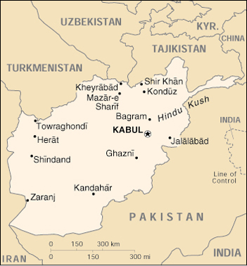
To orient yourself regionally, find Kabul and Jalalabad on the map of Afghanistan, below.
11 posted on
03/03/2006 1:55:13 AM PST by
Boot Hill
("...and Joshua went unto him and said: art thou for us, or for our adversaries?")
To: Spanaway Lori
12 posted on
03/03/2006 2:08:37 AM PST by
Cannoneer No. 4
(Our enemies act on ecstatic revelations from their god. We act on the advice of lawyers.)
To: Spanaway Lori
13 posted on
03/03/2006 2:15:25 AM PST by
Cannoneer No. 4
(Our enemies act on ecstatic revelations from their god. We act on the advice of lawyers.)
FreeRepublic.com is powered by software copyright 2000-2008 John Robinson


