Skip to comments.
Obama State Department set to cede oil-rich Alaska islands to Russia
Washington Times ^
| Monday 20th February
| admin
Posted on 03/16/2012 12:28:02 PM PDT by Candor7
Obama’s State Department is giving away seven strategic, resource-laden Alaskan islands to the Russians. Yes, to the Putin regime in the Kremlin. … The seven endangered islands in the Arctic Ocean and Bering Sea include one the size of Rhode Island and Delaware combined. The Russians are also to get the tens of thousands of square miles of oil-rich seabeds surrounding the islands. The Department of Interior estimates billions of barrels of oil are at stake.
The State Department has undertaken the giveaway in the guise of a maritime boundary agreement between Alaska and Siberia. Astoundingly, our federal government itself drew the line to put these seven Alaskan islands on the Russian side. But as an executive agreement, it could be reversed with the stroke of a pen by President Obama or Secretary Clinton.
The agreement was negotiated in total secrecy. The state of Alaska was not allowed to participate in the negotiations, nor was the public given any opportunity for comment. This is despite the fact the Alaska Legislature has passed resolutions of opposition – but the State Department doesn’t seem to care.
TOPICS: Extended News; Foreign Affairs; Government; News/Current Events; Russia
KEYWORDS: alaska; ntsa; obama; russia; trerason
Navigation: use the links below to view more comments.
first previous 1-20 ... 41-60, 61-80, 81-100, 101-105 next last
To: Brown Deer
So the map included in The Agreement Between the United States of America and the Union of Soviet Socialist Republics On the Maritime Boundary, with Annex, Signed at Washington, June 1, 1990 is something made up? It was not part of the treaty you tried to link it to. It was made afterwards.
The treaty is clear these islands were not part of the 1967 agreement. Do you agree with that?
61
posted on
03/18/2012 5:04:50 AM PDT
by
thackney
(life is fragile, handle with prayer)
To: Brown Deer
62
posted on
03/18/2012 5:05:54 AM PDT
by
thackney
(life is fragile, handle with prayer)
To: Brown Deer
From your link on the 1990 Agreement:
The preamble to the Agreement recalls the 1867 Convention and expresses the desire of the two Parties to resolve issues concerning their maritime boundary. It also sets forth their objective of ensuring that where coastal state jurisdiction could be exercised in the absence of a maritime boundary by either Party in accordance with international law, such jurisdiction is exercised by either the United States or the Soviet Union.
Article 1 records the agreement of the Parties that the line described as the “western limit” in the 1867 Convention (the 1867 Convention Line) is the maritime boundary. It also describes the legal effect of the boundary, obligating each Party to respect the boundary as limiting the extent of its coastal state jurisdiction otherwise permitted by international law for any purpose. It thereby settles the issue of where each side may, consistent with international law, manage offshore resources (the fishery resources of the waters as well as the oil and gas and other resources of the seabed and subsoil) and other oceans uses in marine areas that both claimed or could have claimed.
Article 2 describes the maritime boundary and indicates that it is defined by lines connecting geographic positions set forth in an Annex, which is an integral part of the Agreement.
The maritime boundary proceeds north and south of the Bering Strait from the mid-point between Big Diomede Island (Soviet) and Little Diomede Island (U.S.). North of the Strait, the boundary extends due north along the meridian of this mid-point as far as permitted under international law.
South of the Strait, the boundary generally extends from the same mid point southwestward to 167 degrees East Longitude (the end point of the Convention Line, as described in the 1867 Convention). This end point lies slightly beyond 200 nautical miles of the respective coasts of the United States and the Soviet Union.
- - - - - -
The above confirms the original treaty lines.
Which of those islands do you believe lies East of this line?
- - - - -
Also, the map you posted before, with a more eastern line than the treaty line, does not exist in this document.
Did you read it before you posted? Or did you copy the link from some tin-foil hat conspiracy society?
63
posted on
03/18/2012 5:14:07 AM PDT
by
thackney
(life is fragile, handle with prayer)
To: mickie
Will call my Congressmann and Senator on Monday. You ought to read the rest of the thread first.
This is an old urban legend and false.
64
posted on
03/18/2012 5:15:22 AM PDT
by
thackney
(life is fragile, handle with prayer)
To: thackney
Also, the map you posted before, with a more eastern line than the treaty line, does not exist in this document.
Which map does not exist in which document? In what document does the map that you posted exist?
Did you read it before you posted?
Yes, have you read it?
Which of those islands do you believe lies East of this line?
What islands do you believe lie east and west of 193 degrees?
65
posted on
03/18/2012 8:25:23 AM PDT
by
Brown Deer
(Pray for 0bama. Psalm 109:8)
To: thackney; melancholy
66
posted on
03/18/2012 10:13:40 AM PDT
by
Brown Deer
(Pray for 0bama. Psalm 109:8)
To: thackney
This myth made it to the Washington Times?
We’ve been reading about it Free Republic since the mid-years of George Bush.
That's odd. It was just recently published by Joe Miller on February 26th of this year. How did you read his article way back then?
Joe Miller was the 2010 Republican nominee for the U.S. Senate from Alaska. He is a West Point graduate and decorated combat veteran from the first Gulf War. A former judge, Joe graduated from Yale Law School and was later awarded an advanced economics degree from the University of Alaska.
67
posted on
03/18/2012 10:18:18 AM PDT
by
Brown Deer
(Pray for 0bama. Psalm 109:8)
To: Brown Deer
I don't know what to say to you. You claim the map I posted from the state department is wrong, and the boundary described in the treaty is wrong.
As further proof, you post a link to the same text as the treaty, and a map matching what I posted.
What islands do you believe lie east and west of 193 degrees?
193 is not the dividing line, it is a crossing point on that angled line.
The western boundary of the treaty is defined as the midpoint between Krusenstern and Ratmanoff on the 65 degrees, thirty minutes north latitude. From this point is heads straight north.
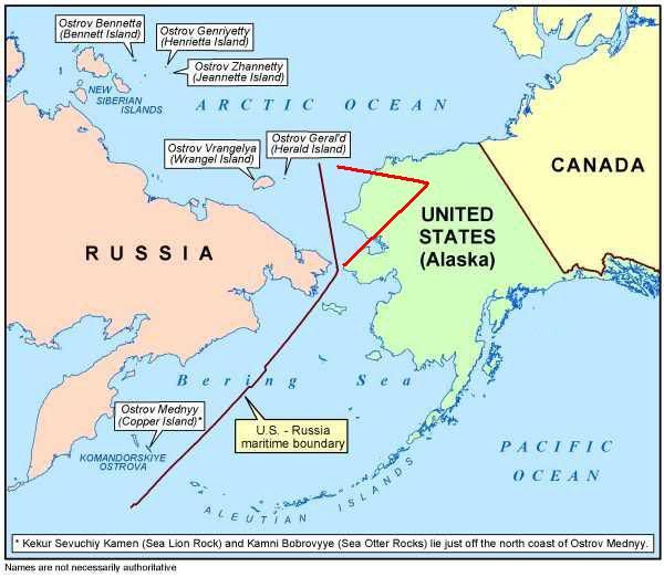
Leaving the claimed islands Bennett, Henrietta, Jeannette, Wrangel and Herald on the Russian side of the border.
Then we go back to the same starting point and head southwest, between St. Lawrence and the southeast point of Cape Choukotski, then continue southwest to pass midway between the island of Attou and Copper island.
Since the border is east of Copper island, Copper island is in Russia.
None of these island were ever in the US. Can we stop this nonsense now?
68
posted on
03/18/2012 3:28:32 PM PDT
by
thackney
(life is fragile, handle with prayer)
To: Brown Deer
As was posted in #23, this crap has been on Free Republic long before any of us considered Obama as a possible presidential candidate.
69
posted on
03/18/2012 3:31:15 PM PDT
by
thackney
(life is fragile, handle with prayer)
To: Brown Deer
70
posted on
03/18/2012 3:48:47 PM PDT
by
thackney
(life is fragile, handle with prayer)
To: thackney
If you would please, could you point me to a link of Joe Miller's writing on this?
When I followed the original examiner (blog) claim about his WND, it turns out he isn't listed and an author and a search did not provide any results.
Are you serious? because that is how I arrived here:
http://www.wnd.com/2012/02/obamas-giveaway-oil-rich-islands-to-russia/
Exclusive: Joe Miller sounds alarm over deal to put land in hands of Putin's Kremlin
Published: 02/16/2012 at 7:55 PM
By Joe Miller
71
posted on
03/18/2012 4:59:29 PM PDT
by
Brown Deer
(Pray for 0bama. Psalm 109:8)
To: thackney
You claim the map I posted from the state department is wrong...
Where did I claim that?
As further proof, you post a link to the same text as the treaty, and a map matching what I posted.
Proof of what? You stated that the map I posted was made up! Now you say it's the same as yours?
What islands do you believe lie east and west of 193 degrees?
You still didn't answer the question.
72
posted on
03/18/2012 5:04:43 PM PDT
by
Brown Deer
(Pray for 0bama. Psalm 109:8)
To: Brown Deer
http://www.wnd.com/2012/02/obamas-giveaway-oil-rich-islands-to-russia/ Thank you.
73
posted on
03/19/2012 4:32:47 AM PDT
by
thackney
(life is fragile, handle with prayer)
To: Brown Deer
You claim the map I posted from the state department is wrong...
Where did I claim that? I messed this up. I thought I read a reply that is not there. Please forgive me.
Proof of what? You stated that the map I posted was made up! Now you say it's the same as yours?
The map you posted as part of #43 includes a heavy dark line of the (false) claim of a border west of the border in the treaty. That is the map I was referring to. I believe the heavy dark border west of Copper and Wrangle is made up, not ever true.
What islands do you believe lie east and west of 193 degrees?
You still didn't answer the question.
Meridan 193 is not the dividing point of the treaty. It is the end point of the line starting midway between the islands of Krusenstern and Ratmanoff, proceeding southwest between St. Lawrence and Cape Choukotski, to midway between Attou and Copper and continuing in this direction until it reaches the 193 merdian.
The 193 merdian is not a dividing line. It is the end of the angled dividing line.
74
posted on
03/19/2012 4:46:21 AM PDT
by
thackney
(life is fragile, handle with prayer)
To: thackney
You still didn't answer the question.
and yet still again. ;-)
75
posted on
03/19/2012 11:14:55 AM PDT
by
Brown Deer
(Pray for 0bama. Psalm 109:8)
To: Brown Deer
I will answer the question after you show me where in the treaty it has meaning besides the end of the angled, western border.
76
posted on
03/19/2012 11:23:18 AM PDT
by
thackney
(life is fragile, handle with prayer)
To: thackney; Berlin_Freeper; Hotlanta Mike; Silentgypsy; repubmom; HANG THE EXPENSE; Nepeta; ...

The last clause of Article I states, "...
to the meridian of one hundred and ninety-three degrees west longitude [167 degrees east]
, so as to include in the territory conveyed the whole of the Aleutian islands east of that meridian."
Why do you keep avoiding the question? Why is it so important to you do defend your president? Why do you continue to call it a myth that the Hon. Joseph Miller wrote the following:
"
But as an executive agreement, it could be reversed with the stroke of a pen by President Obama or Secretary Clinton.
The agreement was negotiated in total secrecy. The state of Alaska was not allowed to participate in the negotiations, nor was the public given any opportunity for comment. This is despite the fact the Alaska Legislature has passed resolutions of opposition – but the State Department doesn’t seem to care."
77
posted on
03/19/2012 12:07:31 PM PDT
by
Brown Deer
(Pray for 0bama. Psalm 109:8)
To: Brown Deer
The last clause of Article I states, "...to the meridian of one hundred and ninety-three degrees west longitude Let us keep the whole sentence in which 193° appears. It is not the border, it is the end of the angled border.
The same western limit, beginning at the same initial point, proceeds thence in a course nearly southwest, through Behring’s Straits and Behring’s Sea, so as to pass midway between the northwest point of the island of St. Lawrence and the southeast point of Cape Choukotski, to the meridian of one hundred and seventy-two west longitude; thence, from the intersection of that meridian, in a southwesterly direction, so as to pass midway between the island of Attou and the Copper Island of the Kormandorski couplet or group, in the North Pacific Ocean, to the meridian of one hundred and ninety-three degrees west longitude, so as to include in the territory conveyed the whole of the Aleutian Islands east of that meridian.
It is not every thing east of 193°. Again, dividing line is starting midway between the islands of Krusenstern and Ratmanoff, proceeding southwest between St. Lawrence and Cape Choukotski, to midway between Attou and Copper and continuing in this direction until it reaches the 193 meridian.
So how can Copper Island be east of the boundary, when the boundary line is defined to be east of the island?
Copper Island is not part of the Aleutian Islands. Aleutian Islands, chain of small islands that separate the Bering Sea (north) from the main portion of the Pacific Ocean (south) and extend in an arc southwest, then northwest, for about 1,100 miles (1,800 km) from the tip of the Alaska Peninsula to Attu Island, Alaska, U.S. {from theEncyclopædia Britannica}
As stated in the treaty it is part of the Kormandorski couplet.
Why is it so important to you do defend your president?
I posted the same refutation of this same myth back when George Bush was accused of it. As several of us have pointed out, this has been refuted on Free Republic many times over many years.
Why do you continue to call it a myth that the Hon. Joseph Miller wrote the following:
With your help, I now know Joe Miller wrote that. It only lowers my opinion of Joe Miller. It does not change the words of the 1867 treaty.
78
posted on
03/19/2012 1:06:20 PM PDT
by
thackney
(life is fragile, handle with prayer)
To: Brown Deer
Sorry, I left out one reply.
The agreement was negotiated in total secrecy.
It was not in secrecy; it has always been reality. Every real state map, include the official maps used by the State of Alaska have NEVER shown these islands to be part of Alaska.
The map you posted yourself in #57 shows the same angled line, dividing the nations with Copper Island in the Russian Territory.
79
posted on
03/19/2012 1:11:51 PM PDT
by
thackney
(life is fragile, handle with prayer)
To: Brown Deer
In the interest of sharing information showing this is not a recent change of border, I found this document while searching on the subject.
It follows the lines as described in the 1867. This was written by the Department of State in 1965.
International Boundary Study
U.S. – Russia Convention Line of 1867
http://www.law.fsu.edu/library/collection/limitsinseas/ibs014.pdf
It give the connecting line of following points as the Western Boundary.
72° 00’.0 N, 168° 58’ 22”.587 W
65° 30’.0 N, 168° 58’ 22”.587 W
64° 12’.3 N, 172° 00’ W
53° 45’.0 N 170° 16’.0 W
50° 36’.4 N 167° 00’ E
193° meridian coincides with 167° East Longitude.
This was written decades ago. It is not a secret conspiracy involving President Bush or Obama.
80
posted on
03/19/2012 1:52:49 PM PDT
by
thackney
(life is fragile, handle with prayer)
Navigation: use the links below to view more comments.
first previous 1-20 ... 41-60, 61-80, 81-100, 101-105 next last
Disclaimer:
Opinions posted on Free Republic are those of the individual
posters and do not necessarily represent the opinion of Free Republic or its
management. All materials posted herein are protected by copyright law and the
exemption for fair use of copyrighted works.
FreeRepublic.com is powered by software copyright 2000-2008 John Robinson