Gen. McInerney said Allama [ Iqbal International ] Airport was the same distance from Malaysia Airlines Flight 370 point of departure, Kuala Lumpuras, its original destination airport, Beijing, China.
Now take a close look at the arc map below, three graphics down and center.
Notice that Pakistan is within the "1 Hour Emergency Fuel Range" (second circle around the red arc), past the "20 minute safety fuel (first circle around the red arc).
So it meets the criteria of being within the Red Arc "handshake" or the last ACARS Satellite "ping" and within fuel range of the Boeing 777 to Allama Iqbal Int'l Airport, Pakestan.
It sounded like Gen. McInerney was all but threatening Pakistan to own up to it now, or suffer the consequences.
Someone sent me another piece of information you should read.
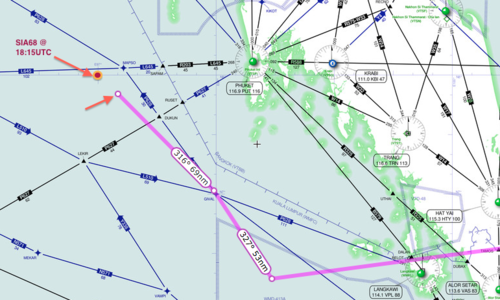
- " Someone on another thread posted a link to a theory that the missing 777 used SIA68 (Singapore Airlines flight 68) to cloak their own airplane until they could get across the Indian Ocean, away from primary radar.
http://keithledgerwood.tumblr.com/post/79838944823/did-malaysian-airlines-370-disappear-using-sia68-sq68 "
- Did Malaysian Airlines 370 disappear using SIA68/SQ68 (another 777)?Monday, March 17, 2014 - 12:01 AM EST
UPDATED: Monday, March 17, 2014 - 9:00 AM EST
 the arc graph (click on it for more detailed info) that shows the estimated range of the aircraft with it's remaining fuel IF it was flying at its MAXIMUM SPEED or 7 hours 30 minutes of fuel.
 Now, from the article:
- this statement towards the end of his article.
- " A satellite was able to pick up a ‘ping’ from the plane until 08:11 local time,
- more than seven hours after it lost radar contact,
- although it was unable to give a precise location.
- north from the border of Kazakhstan and Turkmenistan through to northern Thailand,
and south from Indonesia to the southern Indian Ocean. "
and I don't know whether to trust it or not.
I've been trying to match up the numbers on a "guess-ta-mated" flight path.
You can narrows down the search area if you take all the Satellite "Handshakes" into consideration for the search of runways/landing strips that Malaysia Airlines Flight 370 could have landed on. The Way Point on the northwet side of her screen is "IGREX" on Jet Route "P628" where the heading changes to a more northerly direction 320 degrees to PORT BLAIR Navaid.

- " ...roughly four hours after the jet dropped from civilian radar screens, these people said, the link operated in a kind of standby mode and sought to establish contact with a satellite or satellites.
The arc graph shows the estimated range of the aircraft with it's remaining fuel IF it was flying at its MAXIMUM SPEED or 7 hours 30 minutes of fuel. Now, from the article:
- this statement towards the end of his article.
- " A satellite was able to pick up a ‘ping’ from the plane until 08:11 local time,
- more than seven hours after it lost radar contact,
- although it was unable to give a precise location.
- north from the border of Kazakhstan and Turkmenistan through to northern Thailand,
and south from Indonesia to the southern Indian Ocean. "
That's 7 hours and 31 minutes after takeoff.
- "... The plane departed for an overnight flight from Kuala Lumpur to Beijing at 12:40 a.m. on March 8.
Its communications with civilian air controllers were severed at about 1:20 a.m., and the jet went missing ... "
That leaves 2 Hours 50 minutes to travel from "IGREX" on Jet Route "P628 to an undefined point on that arc of 7 hours 30 minutes from takeoff.
Let's say that the pilot leans the engines out to get the most out of his fuel for distance with the remaining time for "IGREX" and gets 3 hours if time,
before he hits his 20 minutes safety margin on fuel and then starts to burn his 1 hour emergency fuel.
At maximum speed of Mach 0.89 (590 mph, 950 km/h, 512 knots) at a cruise altitude of 35,000 ft , that would allow him 1770 miles of distance (to the red arc), before hitting his reserves.
Let's assume that since he stayed on the Jet Routes, he continued to stay on the Jet Routes.
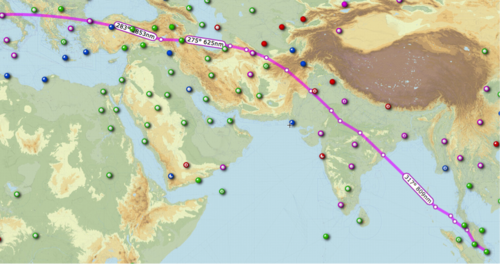
Now take that information and the arc ping map (important to view this map at this link for more details) along with the jet route map, and you can find possible links.
Now I run the numbers on the Jet Routes starting from "IGREX" on Jet Route "P628" and starting subtotaling for a target of 1770 Nautical Miles.
Take a look from SkyVector.com.
Jet Route P628 NW
- IGREX 151 NM to Port Blair
Port Blair 272 NM to VATLA
VALTA 173 NM to URKOK
URKOK 172 NM to KAGUL
KAGUL 51 NM to DORIL
DORIL 99 NM to OPASA
OPASA 75 NM to IKINA
IKINA 28 NM to OPONI
OPONI 121 NM to ASOPO or JABALPUR
-----------
1,142 NM subtotal
---------------
Change route to W66 North to KHAJURAHO
ASOPO 97 NM to KKJ
Change route to W40 NNE via KANPUR to LUCKNOW
KJJ 72 NM to IGONA
IGONA 28 NM to LUCKNOW
Change route to M890 Northwest to SARSAWA
LUCKNOW 87 NM to JALABAD
JALABAD 65 NM to PUMOT
PUMOT 116 NM to SARAWA
--------------
1,607 NM Subtotal
SARAWA 27 NM to ONOGI
ONOGI 26 NM to CHANDIGARH (CHG)
CHG 73 NM to LAKET
LAKET 49 NM to SAMAR
Change Direction North to J220 to SIALKOT (SLT) Airport
SAMAR aprx 75 NM to SIALKOT Airport
------------------
1,857 NM
Now A different Route
From M890 at SARSAWA
--------------
1,607 NM Subtotal
Change route to W39 North to LEH
SARAWA 143 NM to LELAX
LELAX 101 NM to LEH
------------
1,851 NM Subtotal
Change route, direct to HOTAN approximately 030 heading
LEH approx 145 NM to HOTAN
Change Route, via SHACHE via KASHI
HOTAN apx 150 NM to SHACHE approx 310 heading
SHACHE 68 NM via A364 to KASHI
Change Route NNW via TADOT to BISHKEK MANAS
KASHI 100 NM to TADOT approximately 350 heading
TADOT 100 NM to BISHKEK MANAS Airport, Kyrgyzstan
--------------
2,414 NM Total (might be out of range)
==============================================
My Airport of Interest are:
- UDHAMPUR (VIUX)
Runway [18 36] 9028.8 x 148 ft, Asphalt
Sialkot International Airport (IATA: SKT, ICAO: OPST)
Runway 22/04 11811 x 148 ASP
GILGIT (OPGT) Gilgit, Gilgit-Baltistan, Pakistan
Runway [07 25] 5385.6 x 98 ft, Asphalt
Runway 09 / 27 1003.2 x 49 ft / 306 x 15 m
Skardu Airport Pakistan (OPSD), IATA: KDU
Runway: 14/32 11944 Ft x 100 Ft ASP
Runway: 15/33 6501 Ft x 101 Ft ASP
======================
Now a final point, and PLEASE, PLEASE, tyake a look at the linked sources.
Take a close look at this graphic. In the world of Air Traffic Contgrol, "Attention To Detail" is everything.

Being accurate FIRST is everything.
Being safe is everything.
Speed comes later, but accuracy is a must.
Now for other career fields, accuracy isn't stressed as much.
Now let's ASSUME that, in the speed of getting out the information, that graphic is built on the WRONG degree off of that satellite.
Look what that would do to the search area.
What if a Muslim sympathizer was in the chain of people that disseminated that information.
And take a look at the fuel capacity of the different models of Boeing 777-200,
- Maximum Fuel Capacitycan be from 31,000 U.S. gal (117,340 L) to 45,220 U.S. gal (171,170 L) to 47,890 US gal (181,283 L), depending on the configuration,
- 5,240 nautical miles (9,700 km, 6,027 miles) to 7,725 nmi (14,310 km, 8,892 mi) to 9,380 nmi (17,370 km, 10,793 mi), depending on its configuration.
So the search area may change,
- but since we don't know the exact configuration of that particular aircraft,
and we don't know if the Malaysia Officials are revealing ALL of the facts to us, or being honest with us,