
Posted on 09/07/2017 8:09:47 AM PDT by NautiNurse
Dangerous Category 5 Hurricane Irma had a devastating impact on islands in the Caribbean.
Hurricane and Storm surge watches were issued Thursday morning for South Florida. The Florida Keys began evacuating visitors and residents, followed by flood zones in Miami and Miami Beach. Sarasota FL declared a local state of emergency Thursday morning.
Polk County FL Sheriff Grady Judd said Wednesday that law enforcement authorities would check the identities of people who turn up at shelters--and take to jail anyone found to have an active arrest warrant. “If you go to a shelter for Irma and you have a warrant, we’ll gladly escort you to the safe and secure shelter called the Polk County Jail... “If you have a warrant, turn yourself in to the jail — it’s a secure shelter.” Judd also posted that sex offenders and sex predators would not be admitted to the shelters. "We cannot and we will not have innocent children in a shelter with sexual offenders & predators. Period." Judd's statements unleashed a liberal firestorm via Twitter.


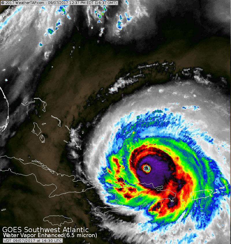
Mash image to find lots of satellite imagery links
Public Advisories
NHC Discussions
NHC Local Weather Statements/Radar Miami, FL
NHC Local Weather Statements/Radar Melbourne, FL
NOAA Local Weather Statements/Radar Jacksonville, FL
NHC Local Weather Statements/Radar Charleston, SC
NHC Local Weather Statements/Radar Wilmington, NC, FL
NHC Local Weather Statements/Radar Morehead City, FL
NHC Local Weather Statements/Radar Norfolk, VA
Buoy Data Caribbean
Buoy Data SE US & GOM
Buoy Data NC/SC/GA
Hebert Box - Mash Pic for Tutorial
Credit: By J Cricket - Modification of map from Wiki
Thanks for this!
can u refer me to the latest forecast
If the latest Euro run came to pass then things would be very different with this cane. It puts it more west and straight up the middle of the spine. Lets hope it is just a fluke.
Another one we learned after Camille. Wash your clothes ahead of the storm so you have clean ones & don’t waste water on it.
And wash all dishes, vacuum the floors, change sheets, etc. No spare electricity for the niceties for a while.
I don’t give a *bleep* about any humans dumb enough to stay at Hemingway House, but would somebody smart enough to leave please grab the cats on their way out??
Check at the start of this thread. There is an NHC forecast map that automatically updates with each new forecast release, typically every 3 hours at this stage of the game.
I live in St Augustine, and we got raked by Matthew - or actually, by the combination of normal high tides and flood surge. Four hundred homes were destroyed, and some people still haven’t got back into their houses. I had to live somewhere else for 3 months but was fortunate enough to have a new house where the builder had all the materials and put his other jobs aside to rebuild his Matthew-destroyed houses.
People here are freaked out. However, we’re doing much better prep than before. Sandbag madness - we rarely get wind damage because the town is in sort of a dip with a barrier island out front - but historically, since the 16th century, hurricane or nor’easter floods have always been our problem.
Is that legit, from a reliable source?

Just watching the Sat pics, I think the westward jog IS happening... Irma is sort of hugging the island of Dom Rep. The friction is pulling the center down a little, and scooting it on a more westward vector.
Also looks to me as if the ridge in front is weakening a little... that means; a LATER turn is possible.. Not really great news for South Florida.
This question is to all on FR who consider themselves storm enthusiasts. I’m wondering how the models that are used for predicting the path and the strength compare with the actuals of the storm. How frequently do the “experts” get it right? How accurate are they? To say that a location is in the cone shows me that there’s still so much they haven’t got the foggiest idea about. That cone is pretty darn big. Gives them lots of leeway to say, hey, we had it right all along. I hate that I’m cynical about things like this. I wish I weren’t.
THAT is simply a beast of a projection!..Like no way out of Florida if it goes this path....
“Weapons...are not allowed at any public shelter.”
You must be a helpless sheeple to use this facility.
Storm surge predictions.
https://www.wunderground.com/cat6/hurricane-irma-extreme-storm-surge-threat-us-and-bahamas
“If Irma makes a trek up the East Coast from Miami to southern South Carolina as a Category 3 or 4 hurricane, as the models currently suggest, the portions of the coast that the eyewall touches will potentially see a massive and catastrophic storm surge, breaking all-time storm surge records and causing many billions of dollars in damage. Even areas up to a hundred miles to the north of where the center makes landfall could potentially see record storm surges. The area of most concern is the northern coast of Florida, the coast of Georgia, and the southern coast of South Carolina, due to the concave shape of the coast, which will act to funnel and concentrate the storm surge to ridiculous heights. If we look at wunderground’s storm surge maps for the U.S. East Coast, we see that in a worst-case Category 3 hurricane hitting at high tide, the storm tide (the combined effect of the storm surge and the tide) ranges from 17 – 20’ above ground along the northern coast of Florida, and 18 – 23 feet above ground along the Georgia coast. If Irma is a Cat 4, these numbers increase to 22 – 28 feet for the coast of Georgia. This is a Katrina-level storm surge, the kind that causes incredible destruction and mass casualties among those foolish enough to refuse to evacuate.”
It pays to learn what the colors represent within the path and cone.....also where the eye is...get that down and you’ll understand a bit more about the cone. But there’s a whole lot ore with that....as depicted throughout this thread.
Disclaimer: Opinions posted on Free Republic are those of the individual posters and do not necessarily represent the opinion of Free Republic or its management. All materials posted herein are protected by copyright law and the exemption for fair use of copyrighted works.
