Skip to comments.
Antarctica May Contain "Oasis of Life"
National Geographic News ^
| Thursday, December 27, 2007
| Christine Dell'Amore
Posted on 12/29/2007 9:07:37 PM PST by SunkenCiv
click here to read article
Navigation: use the links below to view more comments.
first previous 1-20, 21-40, 41-60, 61-80, 81-100 last
To: ForGod'sSake
81
posted on
01/01/2008 11:40:59 PM PST
by
Fred Nerks
(FAIR DINKUM!)
To: ForGod'sSake
Plate Tectonics: A Paradigm Under Threat.LINK.Age of the Seafloor
EXCERPT:
...In the Atlantic, rock and sediment age should range from Cretaceous (120 million years) adjacent to the continents to very recent at the ridge crest. During legs 37 and 43 of the DSDP, Paleozoic and Proterozoic igneous rocks were recovered in cores on the Mid-Atlantic Ridge and the Bermuda Rise, yet not one of these occurrences of ancient rocks was mentioned in the Cruise Site Reports or Cruise Synthesis Reports (Meyerhoff et al., 1996a). Aumento and Loncarevic (1969) reported that 75% of 84 rock samples dredged from the Bald Mountain region just west of the Mid-Atlantic Ridge crest at 45°N consisted of continental-type rocks, and commented that this was a "remarkable phenomenon" – so remarkable, in fact, that they decided to classify these rocks as "glacial erratics" and to give them no further consideration. Another way of dealing with "anomalous" rock finds is to dismiss them as ship ballast. However, the Bald Mountain locality has an estimated volume of 80 km³, so it is hardly likely to have been rafted out to sea on an iceberg or dumped by a ship! It consists of granitic and silicic metamorphic rocks ranging in age from 1690 to 1550 million years, and is intruded by 785-million-year mafic rocks (Wanless et al., 1968). Ozima et al. (1976) found basalts of Middle Jurassic age (169 million years) at the junction of the rift valley of the Mid-Atlantic Ridge and the Atlantis fracture zone (30°N), an area where basalt should theoretically be extremely young, and stated that they were unlikely to be ice-rafted rocks. Van Hinte and Ruffman (1995) concluded that Paleozoic limestones dredged from Orphan Knoll in the northwest Atlantic were in situ and not ice rafted...
82
posted on
01/02/2008 2:23:00 AM PST
by
Fred Nerks
(FAIR DINKUM!)
To: ForGod'sSake
2007 June 22 Arctic Ocean History Is Deciphered by Ocean-Drilling Research Team.LINK. Washington, DC - Sediment cores retrieved from the Arctic's deep-sea floor by the Integrated Ocean Drilling Program's Arctic Coring Expedition (ACEX) have provided long-absent data to scientists who report new findings in the June 21 issue of Nature.
A team of ACEX researchers report that the Arctic Ocean changed from a landlocked body of water (a 'lake stage') through a poorly oxygenated 'estuarine sea' phase to a fully oxygenated ocean at 17.5 million years ago during the latter part of the early Miocene era. The authors attribute the change in Arctic conditions to the evolution of the Fram Strait into a wider, deeper passageway that allowed an inflow of saline North Atlantic water into the Arctic Ocean. Scientists believe that the deep-water connection between the northern Atlantic and Arctic Oceans is a key driver of global ocean circulation patterns...

83
posted on
01/02/2008 2:56:52 AM PST
by
Fred Nerks
(FAIR DINKUM!)
To: Fred Nerks
Plate Tectonics: A Paradigm Under Threat... That's quite an article. I actually read most of it. Compelling arguments against plate tectonic mechanisms as we have come to, or been led to, believe them.
I suppose I've almost reached the conclusion that any, ANY evidence supporting slow, gradual change; the uniformitarian theory, is the only set of "facts" to be peddled to the unwashed. Arguments to the contrary are spoken of as heresy by the "scientific community". Frustrating.
84
posted on
01/02/2008 11:26:47 AM PST
by
ForGod'sSake
(ABCNNBCBS: An enemy at the gates is less formidable, for he is known and carries his banner openly.)
To: Fred Nerks
Why are Thunderbirds extinct? 'Cuz people quit buyin' 'em. ;-)
85
posted on
01/02/2008 11:48:42 AM PST
by
uglybiker
(I do not suffer from mental illness. In fact, I'm enjoying every minute of it.)
To: ForGod'sSake
From Plate Tectonics to Earth Expansion: CAREY. LINK.The Carey Hypothesis.LINK
NEAL ADAMS Quicktime.LINK
Neil Adams 'Bad Astronomy' Forum. LINK.
I like what he says -
I was a good researcher . I wouldn't lose my job. I had no tenure to protect. I'm not interested in public debate. And I'm not afraid of being embarassed , which would likely happen . So , without contacting anyone , I simply dug in. Took 40 years. Heh . So , I know I'm not going to convince anyone overnight , especially folks entrenched with the standard model. Oh , no! I come here knowing I 'll not convince anyone, really . I'm merely planting seeds. All I ask is Please watch the videos first, then , if you can be gentlemen then please do. If you are rude , I simply won't respond. Neal Adams
Your comment - Arguments to the contrary are spoken of as heresy by the "scientific community". Frustrating.
The culprit? Peer Review. I think of it as the science mafia.
86
posted on
01/02/2008 5:08:38 PM PST
by
Fred Nerks
(FAIR DINKUM!)
To: Fred Nerks
You sir, are a cad! I have spent HOURS following some fascinating presentations along with some serious, and not-so-serious discussions/debates. AND followed a few searches of my own. Bottom line: Expanding Earth seems to be a very real possibility, at least to this layman. FWIW, counter-arguments
appear fairly weak and tend to collapse under their own weight. For the most part they seem to rely upon the "conventional wisdom", such as it is.
Then again, maybe I'm easy ;^)
Thanks for the interesting links. I've really got to look into this some more.
87
posted on
01/03/2008 1:17:01 PM PST
by
ForGod'sSake
(ABCNNBCBS: An enemy at the gates is less formidable, for he is known and carries his banner openly.)
To: ForGod'sSake

Underwater Bering Strait:

You might never see Earth quite the same way again.
88
posted on
01/03/2008 1:43:02 PM PST
by
Fred Nerks
(FAIR DINKUM!)
To: Fred Nerks
I need a some perspective or context to make much of the second graphic. Looks like pack ice to me. A little help?
89
posted on
01/03/2008 11:06:11 PM PST
by
ForGod'sSake
(ABCNNBCBS: An enemy at the gates is less formidable, for he is known and carries his banner openly.)
To: ForGod'sSake
http://www.atsr.rl.ac.uk/images/sample/atsr-1/index.shtml
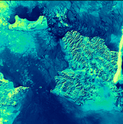
Verging on the Arctic Circle, the sea in this image is packed with ice floes. In the cracks and gaps between the ice, the much less-reflective water surface appears almost black. The brightest area is the finger of cloud on the western side of the image. Also brighter than the icy sea, are the three land areas in the picture. From the western side of the image, the eastern extremity of the Russian Federation reaches out towards the tip of Alaska. The International Date Line bisects the inter-continental gap and then veers south-west keeping St. Lawrence Island with Alaska a day behind the Russian Federation. ATSR data have proved very useful in the detection of sea ice and the location of icebergs.
(This is a 1.6 micron day-time image acquired on 5th February 1992; the area covered is 512 x 512 square km.)
90
posted on
01/03/2008 11:43:04 PM PST
by
Fred Nerks
(FAIR DINKUM!)
To: ForGod'sSake
See #83
...The authors attribute the change in Arctic conditions to the evolution of the Fram Strait into a wider, deeper passageway that allowed an inflow of saline North Atlantic water into the Arctic Ocean... something similar happened to fill the Black Sea. Look at the shoreline of the Bospherus...

Was this a shallow inland sea before the fissure opened?
91
posted on
01/04/2008 12:03:46 AM PST
by
Fred Nerks
(FAIR DINKUM!)
To: ForGod'sSake
92
posted on
01/04/2008 12:22:35 AM PST
by
Fred Nerks
(FAIR DINKUM!)
To: ForGod'sSake
http://daac.gsfc.nasa.gov/oceancolor/images/black_sea.jpg
Recently, geologists Walter Pitman and William Ryan suggested that the Black Sea had been a freshwater lake at one time, and it became an anoxic marine basin fairly recently. Around 5600 B.C., as sea levels rose due to glacial melting, a flood of seawater broke through the Bosporus and inundated the Black Sea basin. The influx of Mediterranean seawater raised the level of the lake about 150 meters, and created the density difference that prevented mixing. Once the Black Sea was filled, the development of anoxia would have happened relatively quickly. One indication of the event is the age of freshwater mussels that died as oxygen concentrations fell. The anoxic bottom waters also hold the promise of preserving ancient wooden vessels, and even buildings in coastal communities that existed before the flood.
(NOTE, November 2003:
As scientific examination of this hypothesis has progressed since it was first proposed by Ryan and Pitman, the dramatic rapid infilling scenario can no longer be supported. See the Black Sea section of the “Associated URLs” below for a recent report on the status of understanding the paleohistory of the Black Sea and surrounding regions. There may have been a much more powerful flood earlier in time, approximately 15-16,000 years ago, resulting from the overflow of the Caspian Sea into the ancient Black Sea basin. The Ryan and Pitman event, while still appearing to have occurred, did not involve as much water or as large a rise in the level of the Black Sea as first proposed.)
Dr. Robert Ballard, famed as the discoverer of the wreck of the Titanic , searched the Black Sea in 1999 and found indications of the ancient shoreline of the freshwater lake. In 2000, Ballard found evidence of ancient settlements on the underwater shore of this ancient lake, well-preserved due to the anoxic conditions, which preserve organic matter well. (Ryan and Pitman proposed that the sudden filling of the Black Sea was the basis for the Noah’s Flood story in the Bible, but we won’t get into that debate here.)
93
posted on
01/04/2008 12:37:04 AM PST
by
Fred Nerks
(FAIR DINKUM!)
To: Fred Nerks
From the western side of the image, the eastern extremity of the Russian Federation reaches out towards the tip of Alaska. The International Date Line bisects the inter-continental gap and then veers south-west keeping St. Lawrence Island with Alaska... What I HAVE been able to determine about the graphic is the people doing the captioning got things a little bass akwards. It's actually 180 degrees out of sync for example. North is south; Alaska is to the left(west?) and Russia is to the right(east?). Consequently, St. Lawrence Island appears to be NORTH of the strait; a line to the southwest would be a long time getting around to St. Lawrence.
Another item regarding your "caption" from your #88: Underwater Bering Strait:
Just curious Fred, are you a provocateur??? Or did I misunderstand your caption?
94
posted on
01/04/2008 12:47:50 PM PST
by
ForGod'sSake
(ABCNNBCBS: An enemy at the gates is less formidable, for he is known and carries his banner openly.)
To: Fred Nerks
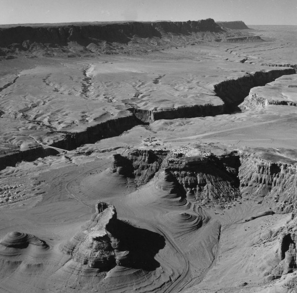
Provocative pics all. Someone with their PhD and heavy on the bona-fides needs to step up and take an objective look at some of the more exotic landscapes around our little blue planet to determine if the “conventional wisdom” re their formation is really wisdom at all, no?
95
posted on
01/04/2008 1:00:04 PM PST
by
ForGod'sSake
(ABCNNBCBS: An enemy at the gates is less formidable, for he is known and carries his banner openly.)
To: Fresh Wind; SunkenCiv
Uh-uh. The entrance to Hollow Earth is at the North Pole, not the South.
96
posted on
01/04/2008 1:03:40 PM PST
by
CholeraJoe
("At last my arm is complete!" Sweeney Todd)
To: ForGod'sSake
Just curious Fred, are you a provocateur??? Or did I misunderstand your caption? Your comment re the Bering Strait graphic illustrates my point to a certain extent, although in this case I didn't look at is closely as you did. The point I was trying to make was a 'break' in the 'landbridge' Beringia.
IF, when the Atlantic opened at the Fram Strait: #83 The authors attribute the change in Arctic conditions to the evolution of the Fram Strait into a wider, deeper passageway that allowed an inflow of saline North Atlantic water into the Arctic Ocean... my interest was drawn to that region.
I'm simply not taking the evolution of the Fram Strait into a wider, deeper passageway as an isolated phenomenon.
The Black Sea was also a fresh water body.
Now see this:

Spain/Africa.

Sediment samples from the bottom of the Mediterranean Sea that include evaporite minerals, soils, and fossil plants show that about five million years ago the Strait was topographically blocked and the Sea had evaporated into a deep basin far lower in elevation than the oceans.
97
posted on
01/04/2008 2:13:24 PM PST
by
Fred Nerks
(FAIR DINKUM!)
To: CholeraJoe; Fred Nerks
Either way, it’s a great place to vacation. ;’) Of course, the Agartha entrance is easier to access.
98
posted on
01/04/2008 10:26:56 PM PST
by
SunkenCiv
(https://secure.freerepublic.com/donate/____________________Profile updated Sunday, December 30, 2007)
99
posted on
03/19/2016 12:36:05 PM PDT
by
SunkenCiv
(Here's to the day the forensics people scrape what's left of Putin off the ceiling of his limo.)
100
posted on
03/19/2016 12:36:12 PM PDT
by
SunkenCiv
(Here's to the day the forensics people scrape what's left of Putin off the ceiling of his limo.)
Navigation: use the links below to view more comments.
first previous 1-20, 21-40, 41-60, 61-80, 81-100 last
Disclaimer:
Opinions posted on Free Republic are those of the individual
posters and do not necessarily represent the opinion of Free Republic or its
management. All materials posted herein are protected by copyright law and the
exemption for fair use of copyrighted works.
FreeRepublic.com is powered by software copyright 2000-2008 John Robinson

