

Posted on 01/03/2015 4:10:32 PM PST by Fred Nerks
“Can you tell me what “bi-directional winds” are?”
Using North America as an example, you can watch the cyclonic weather systems generally move from west to east through the western and mid-western states. Elsewhere, you also see some of the cyclonic weather systems generally moving southeasterly out of Canada and into the United States before heading easterly. Other cyclone systems come out of the Atlantic ocean and circle clockwise over the Gulf of Mexico, northwards into the Midwest or along the Eastern coastline, before heading northeastwards back out into the Atlantic Ocean. These weather systems are steered in these directions by such forces as the Coriolis Force produced by the Earth’s rotation on its axis and the powerful Jetstream winds traveling between the thermal convergence and heat exchange of the Troposphere and the Stratosphere. When one of the cyclonic and anti-cyclonic weather systems pass overhead in the atmosphere, you can watch the wind direction move around the compass as different areas of the cyclonic winds push in constantly changing directions around the compass.
Bidirectional winds which persist for seasonal periods of time do not share that type of behavior seen within a typical cyclonic weather system. Instead, they are a special case of the trade winds. Trade winds came by their name because mariners learned that the winds tended to more reliably blow in one direction than others during a particular season, so the mariners could more often trust such little varying wind directions to propel their trader sailing ships to the intended destinations across the oceans. Bidirectional winds are a special case with respect to the trade winds, because the planetary level atmospheric circulation cells meet in a convergence zone and result in persistent wind direction in one direction or its opposite direction. The trade winds outside this convergence zone also change direction with the season, but they do so in a somewhat less linear fashion due to their liberation from the effects of being within the convergence zone where the winds of the planetary cells buffet and cancel each other except within two linear directions.
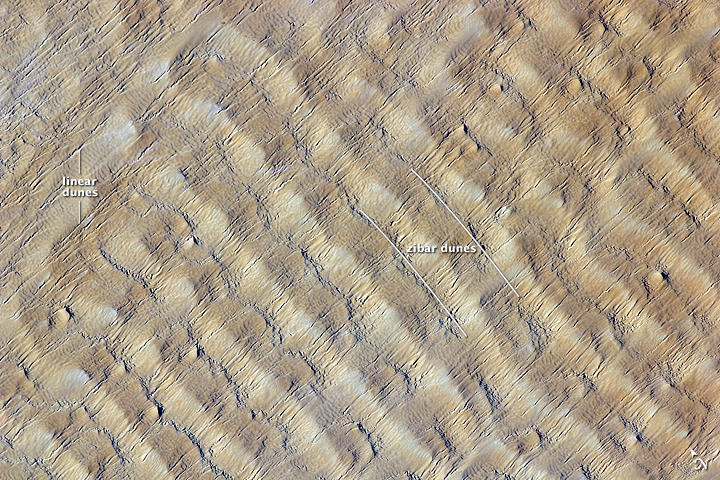
“Where ever there is wind and sand in any amount you will find linear dunes.”
Yes, there are multiple causes for the production of linear dunes. The scale of those being discussed in Southern Africa are extensive in areal size because they are a result of the interactions between the Hadley and Mid-Latitude cells. You can see the relationship by examining the location of their convergence zone overhead of these linear dunes. The Congo jungles and the Kalihara Desert exist because of these cells.
Oh, okay, I’d heard of this guy before, he has found some tantalizing formations all over the place, using Google Earth. I probably d/led his book a while back.
Yep. Thousands of so-called 'out of place artifacts' also point to the fact that this isn't the first time modern civilization has arisen on this planet.
The path of discovery is long, and we're still far from knowing everything about mankind's past.
Those lines aren't straight. They wave all over the place, and are obviously wind generated.
The lines in the original post are unnaturally straight, and are parallel to each other. They're also not the result of wind blown sand, as in the pics you posted.
Can’t be. The loons have declared that nature doesn’t make straight lines.
I have now read your link “Wind as a Geologic Agent.” The parallel lines visible on the Google Earth map do NOT have the characteristics of any of the dune processes shown. They have two slightly raised lines with a narrow sunken area between, or two slightly raised lines with a wide flat area between. In other words, the progression is raised, narrow sunken, raised, wide flat, raised, narrow sunken, raised, wide flat, raised, narrow sunken, raised, wide flat, etc. etc. etc. for dozens or more repetitions. Where are there any generally accepted as natural dune features like that??? In addition the ridges are not high like dunes tend to be especially when spaced that far apart. Look at the Google Map link at Comment 48. Go in close, 100 and 200 feet. Look at a lot of them in different areas. No high dunes, and always the wide, narrow, wide, narrow pattern.
I have given the whole issue more thought. Since this is a seasonally heavily watered area, and even more so in the past, the ground must be mostly silt and organic matter, many feet deep. Thus, no rocks for building, thus no human artifacts that might be 7000 to 14,000 years old. The nearest recognized large stone feature is Great Zimbabwe to the east. Very little is known about that feature. Obviously, archaeologists need to get in there and spend a lot of time tying the region together developmentally. From what I could see of existing structures, they are rectangular enclosures, probably brush, and round, small huts, often not on what are probably agricultural efforts in the “canals”, but up on the “ridges.” I will need to look in other areas to see if the pattern is the same. Most of what I look at was in the area between Etosha and the Okavango River.


Tamacha appears to have been, or still is, a village, there are some buildings that might be of recent construction. I haven't found anything yet on a place named Tamacha in Botswana.


Laurens van der Post panel, 2006
The Tsodilo Hills are a UNESCO World Heritage Site (WHS), consisting of rock art, rock shelters, depressions, and caves. It gained its WHS listing in 2001 because of its unique religious and spiritual significance to local peoples, as well as its unique record of human settlement over many millennia. UNESCO estimates that there are over 4500 rock paintings at the site. The site consists of a few main hills known as the Child Hill, the Female Hill, and the Male Hill. These hills are of great cultural and spiritual significance to the San of the Kalahari.
Oh, so you mean bi-directional winds are winds that blow back and forth in the same direction, changing only infrequently?
“This system is in one of the driest places on earth. It needs a large river to feed it.”
At the time it was viewed as an affirmative action, shovel ready project for those left behind.
Unfortunately the last Five Year Plan missed the estimate on water supply by a huge margin, so the laborers moved on in order to get captured for slavery, and get
“Out of Africa”

I'd love to ask Caterpillar to determine the amount of earth which has been displaced in these formations, then to calculate how many D-9 Cats & self-loading Pans would be required working "X" number of years to complete this project.
Just the total area covered, the minimal elevation change over that area and the regularity of spacing & azimuth is absolutely astounding!
Perhaps an interstellar version of a combination of these two? /S
![]()

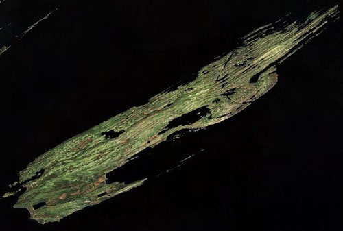
Isle Royale in Lake Superior is made of parallel ridges and valleys. It sits on the edge of an ancient rift valley.
Thanks glee’. The whole formation is fairly uniform, and spread out over such a large area, that it is bound to be natural, because it would otherwise be tremendously extravagant of labor, not to mention that it would have been done to address a lack of water, and that characteristic doesn’t correlate with a large population capable of constructing it over such a large area. One of the papers someone up there linked had the steps needed to produce what is seen, and it seemed plausible. The nearby delta used to drain into a now-vanished lake, and these straight-line formations are seen on both sides. This isn’t to say that it could not be artificial, just that one would expect different areas of it to be more eroded because it is older, with a smallish population gradually moving to find fertile soil and abandoning former areas.


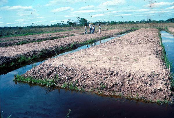
However, it seems most unlikely, the distance between the 'channels' is far too wide at almost a mile, to practise any form of agriculture we can image. Furthermore, the raised fields of which I have various images collected, all have cross-channels, without which there would be no entry or exit possible, to the watercraft presumed to have been used used for transportation.
Fossilized Tiwanaku Farmland from the Above (Suka kollas)
“changing only infrequently?”
No, that is not how winds work, especially when the wind force is light and variable. Look at how trade winds have a predominate direction during a season when the wind force is substantial. When these stronger force winds occur within a boundary area between two major air masses such as the Hadley cell and the Mid-Latitude cell, the wind forces tend to cancel each other out except along the plane of contact, leaving a predominate wind flow in one direction or the opposite direction along the axis parallel to the boundary between the two major air masses.
Disclaimer: Opinions posted on Free Republic are those of the individual posters and do not necessarily represent the opinion of Free Republic or its management. All materials posted herein are protected by copyright law and the exemption for fair use of copyrighted works.