Thanks FromLori.
 |
||
| · join · view topics · view or post blog · bookmark · post new topic · subscribe · | ||
Posted on 12/14/2010 9:56:01 AM PST by FromLori
There’s a 2003 USGS pub with the GIS data of historical seismicity of the central US (Mississippi valley, basically), IIRC, but I can’t recall the authors. I’ll let you know if I find it.
Of course, the old data in it is sketchy.
Actually they have the most current data here (assuming my 30 second look at the site is correct!):
http://earthquake.usgs.gov/research/data/
And, you can download a file of well locations here (Excel format):
http://www.geology.ar.gov/home/fayetteville_play.htm
I usually use the crippled version of GlobalMapper that the USGS gives away free here:
http://mcmcweb.er.usgs.gov/drc/dlgv32pro/
It will import comma separated value files which you can make from the Excel file of wells and the txt files of earthquakes. Assuming you can tell what the projections are for each data set, it may even provide a useful map! I may play with it tomorrow.
Now I am going to go look for DRG topo files for Arkansas.
Yep, that was my first thought. I hope we’re wrong.
I have said several times that I think we will have one more world class earthquake or volcano before the earth settles down for another quieter period of around 70 years. It seems at least in the past few centuries that every 100 years there is a period of about 30 years when there are more and greater earthquakes and volcanos. I think this cycle is not quite over.
Brick homes are a common thing in the Arkansas/Oklahoma area.
Brick homes are a common thing in the Arkansas/Oklahoma area.

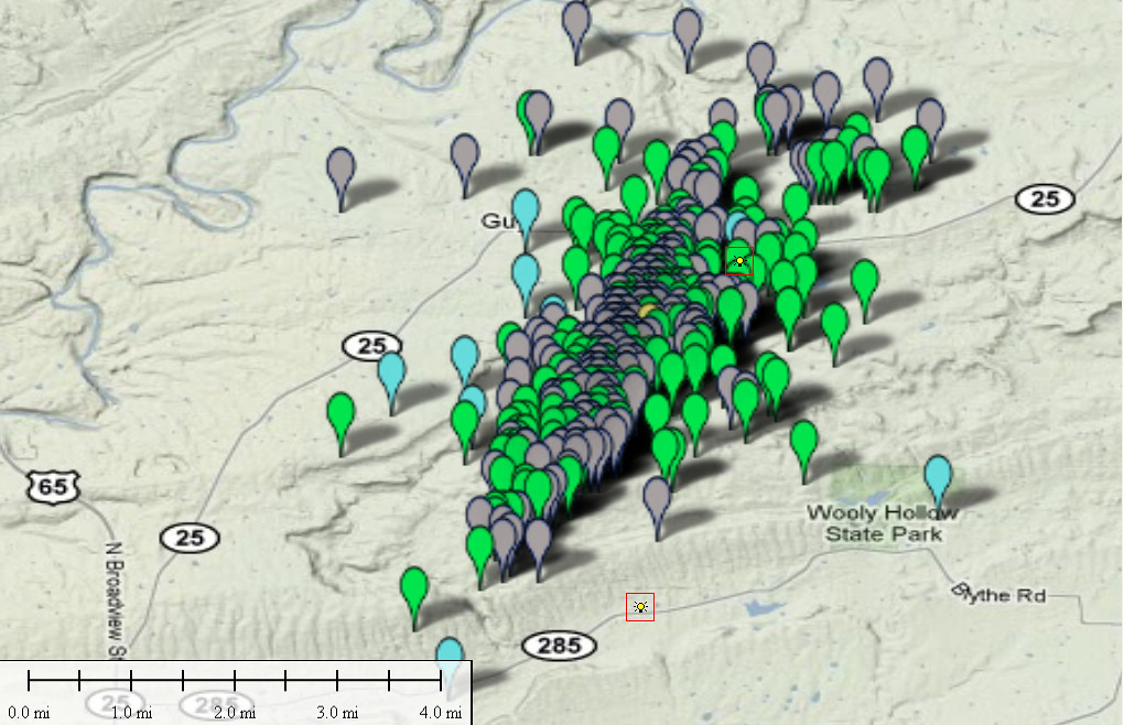
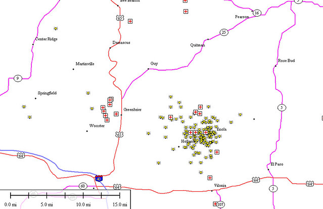
Then I took the screen dump of recent earthquakes around Guy from the AGS site and plotted the nearby injection well locations:
What about pre-recent earthquakes?
Correlation based on geology of predisposition of both gas content and tectonic activity?
I think it’s the timing that’s the key...did the earthquakes pre-date the drilling?
With that kind of logic you will never be allowed into the Green Church. ;>) They do have a list of all historical earthquakes, but I am not sure it includes the smaller ones. I will take a look at it today. It would be fun to make an animated Gif of a time lapse of earthquakes in the area.
One thing I find interesting about the maps I posted is the scale of the area with recent activity versus the location of injection wells. I find it hard to believe that those two wells could have been responsible for such a large region of seismic activity.
Heh. Both churches consider me a heretic.
I suspect you’ll find the dataset biased by the lack of earlie observations—no sensitive detectors might make it seem quiet in earlier times.
Disclaimer: Opinions posted on Free Republic are those of the individual posters and do not necessarily represent the opinion of Free Republic or its management. All materials posted herein are protected by copyright law and the exemption for fair use of copyrighted works.