Skip to comments.
Michigan, Upper Midwest Potentially Dangerous Weather
NOaa.gov ^
| Saturday, January 4, 2014
| US Government (NOAA)
Posted on 01/04/2014 5:07:30 PM PST by madison10
Winter Storm Warning URGENT - WINTER WEATHER MESSAGE NATIONAL WEATHER SERVICE CLEVELAND OH 406 PM EST SAT JAN 4 2014
...SNOW AND DANGEROUSLY LOW WIND CHILLS ARE ON THE WAY...
.A WINTER STORM SYSTEM WILL MOVE NORTHEAST ACROSS OHIO SUNDAY SPREADING SNOW ACROSS THE ENTIRE AREA. A STRONG ARCTIC FRONT WILL FOLLOW USHERING IN BITTER COLD ARCTIC AIR FOR THE BEGINNING OF THE WORK WEEK.
OHZ020>023-029>033-037-038-047-050515- /O.UPG.KCLE.WC.A.0001.140106T0600Z-140107T2000Z/ /O.NEW.KCLE.WC.W.0001.140106T2200Z-140108T1400Z/ /O.NEW.KCLE.WS.W.0002.140105T2300Z-140106T2200Z/ MEDINA-SUMMIT-PORTAGE-TRUMBULL-RICHLAND-ASHLAND-WAYNE-STARK- MAHONING-MORROW-HOLMES-KNOX- INCLUDING THE CITIES OF...MEDINA...AKRON...RAVENNA...WARREN... MANSFIELD...ASHLAND...WOOSTER...CANTON...YOUNGSTOWN... MOUNT GILEAD...MILLERSBURG...MOUNT VERNON 406 PM EST SAT JAN 4 2014
...WINTER STORM WARNING IN EFFECT FROM 6 PM SUNDAY TO 5 PM EST MONDAY... ...WIND CHILL WARNING IN EFFECT FROM 5 PM MONDAY TO 9 AM EST WEDNESDAY...
THE NATIONAL WEATHER SERVICE IN CLEVELAND HAS ISSUED A WINTER STORM WARNING FOR HEAVY SNOW AND BLOWING SNOW WHICH IS IN EFFECT FROM 6 PM SUNDAY TO 5 PM EST MONDAY. A WIND CHILL WARNING HAS ALSO BEEN ISSUED. THIS WIND CHILL WARNING IS IN EFFECT FROM 5 PM MONDAY TO 9 AM EST WEDNESDAY.
* ACCUMULATIONS...SUNDAY SNOWFALL OF 1 TO 3 INCHES...SLIGHTLY LOWER NEAR OHIO PENNSYLVANIA BORDER IF MIXED PRECIPITATION OCCURS. SUNDAY NIGHT SNOWFALL OF 3 TO 5 INCHES. STORM TOTALS OF 4 TO 8 INCHES.
* TIMING...SNOW WILL BEGIN BY MID MORNING WITH THE HEAVIEST SNOW EXPECTED TO FALL BETWEEN 5 PM AND MIDNIGHT. SNOW WILL CONTINUE INTO EARLY MONDAY MORNING BUT WILL DECREASE IN INTENSITY. THE MAIN CONCERN AFTER MIDNIGHT WILL BE STRONG WESTERLY WINDS THAT WILL USHER FRIGID AIR INTO THE REGION. DANGEROUS WIND CHILLS OF 20 TO 40 DEGREES BELOW ZERO WILL BE POSSIBLE. BLOWING AND DRIFTING SNOW WILL ALSO BE A PROBLEM.
* WINDS...GENERALLY LIGHT SUNDAY. 15 TO 30 MPH WITH GUSTS AROUND 35 MPH POSSIBLE SUNDAY NIGHT THROUGH TUESDAY. WINDS FROM THE NORTHWEST SUNDAY NIGHT THEN BACKING TO THE WEST AND SOUTHWEST.
* VISIBILITIES...WILL DROP TO BELOW A HALF MILE AT TIMES IN THE HEAVIEST SNOWFALL SUNDAY AFTERNOON INTO SUNDAY EVENING. AS THE STRONGER WINDS ARRIVE AFTER MIDNIGHT VISIBILITIES MAY DROP TO NEAR ZERO IN BLOWING SNOW.
* IMPACTS...SNOW COVERED ROADS. BLOWING AND DRIFTING SNOW SUNDAY NIGHT THROUGH TUESDAY. IT MAY TAKE 10 MINUTES OR LESS TO GET FROSTBITE ON EXPOSED SKIN MONDAY INTO TUESDAY.
* TEMPERATURES...DROPPING TO BELOW ZERO ON MONDAY AND REMAINING NEAR OR BELOW ZERO INTO WEDNESDAY. MORNING LOWS IN THE TEENS BELOW ZERO TUESDAY MORNING.
* WIND CHILL READINGS...20 TO AS LOW AS 40 DEGREES BELOW ZERO AT TIMES ESPECIALLY MONDAY THROUGH WEDNESDAY MORNING.
PRECAUTIONARY/PREPAREDNESS ACTIONS...
A WINTER STORM WARNING IS ISSUED WHEN SEVERE WINTER WEATHER IS EXPECTED. HEAVY SNOW AND/OR ICE WILL CAUSE HAZARDOUS DRIVING CONDITIONS. IF YOU WILL BE TRAVELING IN THE WARNING AREA YOU SHOULD CHOOSE AN ALTERNATE ROUTE IF POSSIBLE, OR YOU SHOULD USE EXTREME CAUTION IF TRAVEL IS UNAVOIDABLE. STAY TUNED TO NOAA WEATHER RADIO FOR FURTHER DETAILS OR UPDATES.
A WIND CHILL WARNING IS ISSUED WHEN A STRONG WIND WILL COMBINE WITH COLD TEMPERATURES TO CREATE DANGEROUSLY COLD CONDITIONS FOR EXPOSED SKIN. THE WIND WILL MAKE IT FEEL LIKE IT IS 25 DEGREES BELOW ZERO OR COLDER FOR SEVERAL HOURS. THOSE PLANNING TO VENTURE OUTDOORS SHOULD USE COMMON SENSE AND DRESS WARMLY.
***********************
Wind Chill Warning URGENT - WINTER WEATHER MESSAGE NATIONAL WEATHER SERVICE CLEVELAND OH 406 PM EST SAT JAN 4 2014
...SNOW AND DANGEROUSLY LOW WIND CHILLS ARE ON THE WAY...
.A WINTER STORM SYSTEM WILL MOVE NORTHEAST ACROSS OHIO SUNDAY SPREADING SNOW ACROSS THE ENTIRE AREA. A STRONG ARCTIC FRONT WILL FOLLOW USHERING IN BITTER COLD ARCTIC AIR FOR THE BEGINNING OF THE WORK WEEK.
OHZ020>023-029>033-037-038-047-050515- /O.UPG.KCLE.WC.A.0001.140106T0600Z-140107T2000Z/ /O.NEW.KCLE.WC.W.0001.140106T2200Z-140108T1400Z/ /O.NEW.KCLE.WS.W.0002.140105T2300Z-140106T2200Z/ MEDINA-SUMMIT-PORTAGE-TRUMBULL-RICHLAND-ASHLAND-WAYNE-STARK- MAHONING-MORROW-HOLMES-KNOX- INCLUDING THE CITIES OF...MEDINA...AKRON...RAVENNA...WARREN... MANSFIELD...ASHLAND...WOOSTER...CANTON...YOUNGSTOWN... MOUNT GILEAD...MILLERSBURG...MOUNT VERNON 406 PM EST SAT JAN 4 2014
...WINTER STORM WARNING IN EFFECT FROM 6 PM SUNDAY TO 5 PM EST MONDAY... ...WIND CHILL WARNING IN EFFECT FROM 5 PM MONDAY TO 9 AM EST WEDNESDAY...
THE NATIONAL WEATHER SERVICE IN CLEVELAND HAS ISSUED A WINTER STORM WARNING FOR HEAVY SNOW AND BLOWING SNOW WHICH IS IN EFFECT FROM 6 PM SUNDAY TO 5 PM EST MONDAY. A WIND CHILL WARNING HAS ALSO BEEN ISSUED. THIS WIND CHILL WARNING IS IN EFFECT FROM 5 PM MONDAY TO 9 AM EST WEDNESDAY.
* ACCUMULATIONS...SUNDAY SNOWFALL OF 1 TO 3 INCHES...SLIGHTLY LOWER NEAR OHIO PENNSYLVANIA BORDER IF MIXED PRECIPITATION OCCURS. SUNDAY NIGHT SNOWFALL OF 3 TO 5 INCHES. STORM TOTALS OF 4 TO 8 INCHES.
* TIMING...SNOW WILL BEGIN BY MID MORNING WITH THE HEAVIEST SNOW EXPECTED TO FALL BETWEEN 5 PM AND MIDNIGHT. SNOW WILL CONTINUE INTO EARLY MONDAY MORNING BUT WILL DECREASE IN INTENSITY. THE MAIN CONCERN AFTER MIDNIGHT WILL BE STRONG WESTERLY WINDS THAT WILL USHER FRIGID AIR INTO THE REGION. DANGEROUS WIND CHILLS OF 20 TO 40 DEGREES BELOW ZERO WILL BE POSSIBLE. BLOWING AND DRIFTING SNOW WILL ALSO BE A PROBLEM.
* WINDS...GENERALLY LIGHT SUNDAY. 15 TO 30 MPH WITH GUSTS AROUND 35 MPH POSSIBLE SUNDAY NIGHT THROUGH TUESDAY. WINDS FROM THE NORTHWEST SUNDAY NIGHT THEN BACKING TO THE WEST AND SOUTHWEST.
* VISIBILITIES...WILL DROP TO BELOW A HALF MILE AT TIMES IN THE HEAVIEST SNOWFALL SUNDAY AFTERNOON INTO SUNDAY EVENING. AS THE STRONGER WINDS ARRIVE AFTER MIDNIGHT VISIBILITIES MAY DROP TO NEAR ZERO IN BLOWING SNOW.
* IMPACTS...SNOW COVERED ROADS. BLOWING AND DRIFTING SNOW SUNDAY NIGHT THROUGH TUESDAY. IT MAY TAKE 10 MINUTES OR LESS TO GET FROSTBITE ON EXPOSED SKIN MONDAY INTO TUESDAY.
* TEMPERATURES...DROPPING TO BELOW ZERO ON MONDAY AND REMAINING NEAR OR BELOW ZERO INTO WEDNESDAY. MORNING LOWS IN THE TEENS BELOW ZERO TUESDAY MORNING.
* WIND CHILL READINGS...20 TO AS LOW AS 40 DEGREES BELOW ZERO AT TIMES ESPECIALLY MONDAY THROUGH WEDNESDAY MORNING.
PRECAUTIONARY/PREPAREDNESS ACTIONS...
A WINTER STORM WARNING IS ISSUED WHEN SEVERE WINTER WEATHER IS EXPECTED. HEAVY SNOW AND/OR ICE WILL CAUSE HAZARDOUS DRIVING CONDITIONS. IF YOU WILL BE TRAVELING IN THE WARNING AREA YOU SHOULD CHOOSE AN ALTERNATE ROUTE IF POSSIBLE, OR YOU SHOULD USE EXTREME CAUTION IF TRAVEL IS UNAVOIDABLE. STAY TUNED TO NOAA WEATHER RADIO FOR FURTHER DETAILS OR UPDATES.
A WIND CHILL WARNING IS ISSUED WHEN A STRONG WIND WILL COMBINE WITH COLD TEMPERATURES TO CREATE DANGEROUSLY COLD CONDITIONS FOR EXPOSED SKIN. THE WIND WILL MAKE IT FEEL LIKE IT IS 25 DEGREES BELOW ZERO OR COLDER FOR SEVERAL HOURS. THOSE PLANNING TO VENTURE OUTDOORS SHOULD USE COMMON SENSE AND DRESS WARMLY.
&&
TOPICS: Chit/Chat; Local News; Outdoors; Weather
KEYWORDS: michigan; ohio; prepare; recordbreaking; storm; weather
Navigation: use the links below to view more comments.
first previous 1-20, 21-40, 41-60, 61-63 next last
To: dforest
the world according to the weather channel.
41
posted on
01/04/2014 6:17:15 PM PST
by
QualityMan
(Don't Tread on Me)
To: sig229
Nobody knows there is a Sturgis Mi. ‘cept those who have lived there. For me it must have been in the 50s when I was a tyke. Lived by the lake.
Still own part of 40 acres outside of Reed City. Fantasized about retiring there ha ha ha ha.
To: dforest
True. Hercules impacts millions! Live team coverage!
To: madison10
Dang that is cold. Not sure what is worse - the arctic weather up north or the 100+ days of summer in Texas. At least it will eventually warm up above zero up there. We never get a break unless a hurricane comes in.
To: Free Vulcan
Go Niners! Should be a hell of a game.
45
posted on
01/04/2014 6:20:20 PM PST
by
Lurker
(Violence is rarely the answer. But when it is it is the only answer.)
To: Windflier
Nonsense. The polar ice caps are melting and seas are rising. ...But did not our grate leader Brakabama say:
"This was the moment when the rise of the oceans began to slow,and our planet began to heal.
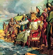
Welcome King Barack "Canute" Obama the Great.....
...Obama issues an Executive Order to the Sun...
....to increase it's magnetic field....
and make a good crop of sunspots before elections in 2016....
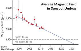
(PhysOrg.com) -- Sunspot formation is triggered by a magnetic field, which scientists say is steadily declining. They predict that by 2016 there may be no remaining sunspots, and the sun may stay spotless for several decades.
The last time the sunspots disappeared altogether was in the 17th and 18th century, and coincided with a lengthy cool period on the planet known as the Little Ice Age....and lasted 400 years.
Good luck surviving with no electricity and GE modified seeds.
46
posted on
01/04/2014 6:25:19 PM PST
by
spokeshave
(OMG.......Schadenfreude overload is not covered under Obamacare :-()
To: Delta Dawn
Cold wave from Canada dropped down about to DC and stayed for 2 weeks. Hi temp? About 20 below. I was a little skeptical of what you were saying and looked it up...sure enough, -18 at Dulles.
Must have been frozen pipes and frozen government workers galore.
47
posted on
01/04/2014 6:25:39 PM PST
by
steve86
(Some things aren't really true but you wouldn't be half surprised if they were.)
To: Allen In Texas Hill Country
I used to work for a company down to Sturgis bringing repo cars back from around the midwest.
I also worked in Reed city when I lived in Evart.
48
posted on
01/04/2014 6:26:42 PM PST
by
cripplecreek
(REMEMBER THE RIVER RAISIN!)
To: spokeshave
All that fracking for natural gas will come in handy.
49
posted on
01/04/2014 6:32:27 PM PST
by
rlbedfor
To: rlbedfor
You’ve heard they’ve found oil recently in Michigan, right? Think it was regular drilling, not fracking, though.
To: gorush
It’s winter for God sake. Stay in the dam house. All of sudden Americans can’t handle a few months of winter.
51
posted on
01/04/2014 6:34:58 PM PST
by
angcat
To: angcat
It’s winter for God sake. Stay in the dam house. All of sudden Americans can’t handle a few months of winter.Yes, it IS winter, but after the last ten plus years of fairly mild winters there are those who may have forgotten, or not yet experienced such extremes, especially the freezing temperature.
To: madison10
I had not. That is good too. All the arrows in the quiver.
53
posted on
01/04/2014 6:43:42 PM PST
by
rlbedfor
To: Ditter
I love cold weather!”
I prefer that the temp never be lower than my age. Since you like the cold, please go north for the rest of the winter and take the cold with you. You can return in the spring.
54
posted on
01/04/2014 7:09:23 PM PST
by
Grams A
(The Sun will rise in the East in the morning and God is still on his throne.)
To: cripplecreek
There are advantages to working from home. :)
The only thing I am in danger of is running out of marshmallows for the hot chocolate. And if worse comes to worse I can switch to whipped cream.
55
posted on
01/04/2014 7:13:21 PM PST
by
Harmless Teddy Bear
(Proud Infidel, Gun Nut, Religious Fanatic and Freedom Fiend)
To: madison10
50 for a high here in Florida tomorrow and it’s freezing. Going to have to break out the blue jeans and socks.LOL!
56
posted on
01/04/2014 7:37:57 PM PST
by
diverteach
(If I find liberals in heaven after my death.....I WILL BE PISSED!!!)
To: diverteach
To: Grams A
I am 73 how old are you grammie?
58
posted on
01/04/2014 7:45:10 PM PST
by
Ditter
To: diverteach
With football and the unseasonable cold weather here in San Diego, I can’t see myself leaving the house. Socks and blue jeans are just not appropriate in 75-degree weather...
59
posted on
01/04/2014 8:06:47 PM PST
by
driveserve
(You likes to drink? Of course you do! Who da hell don't?)
To: okie01
It was part of my job to read the all caps weather reports.
It is no longer my job, I don’t read them anymore. Any format but that.
Navigation: use the links below to view more comments.
first previous 1-20, 21-40, 41-60, 61-63 next last
Disclaimer:
Opinions posted on Free Republic are those of the individual
posters and do not necessarily represent the opinion of Free Republic or its
management. All materials posted herein are protected by copyright law and the
exemption for fair use of copyrighted works.
FreeRepublic.com is powered by software copyright 2000-2008 John Robinson