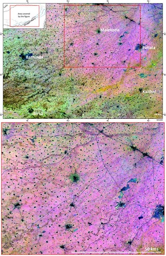
A composite image of vegetation indices in Northwest India created from 1254 images reveals a complex palaeoriver network comprised of more than 8000km of palaeochannels. The new MSRM algorithm will contribute to mapping the complete ancient palaeoriver network of northwest India and to a better understanding of how the Indus Civilisation operated c. 2600-1900 BC. Hector A. Orengo
1 posted on
02/18/2018 3:55:09 PM PST by
SunkenCiv
To: SunkenCiv
Don’t tell the Hoffmans - they’ll pack up and head out on another quixotic gold rush.
Thar’s gold in them thar paleochannels!
3 posted on
02/18/2018 6:15:06 PM PST by
Noumenon
(It isn't racist if it's true, is it?)
To: SunkenCiv
There is a 1850's dugout in Palo Pinto County I never did find. Can they help me out?
It's just NW of Lipan.
4 posted on
02/18/2018 6:18:17 PM PST by
Deaf Smith
(When a Texan takes his chances, chances will be taken that's fore sure)
FreeRepublic.com is powered by software copyright 2000-2008 John Robinson