Skip to comments.
New Orleans Levee Failure Assessment - Part V
numerous
Posted on 11/07/2005 8:54:03 PM PST by jeffers
New Orleans Levee Failure Analysis - Part V
Contents
Introduction and Basic Levee Construction, Section and Elevation Details
Section 1. Pre-Landfall Flooding in Kenner and Western Metairie of East Jefferson Parish
Section 2. Analysis of the 17th Street and London Canal Breaches and Post Katrina Flood Sequence in Downtown New Orleans
Section 3. Surge Sequence for the Industrial Canal Basin, Analysis of the Five Major Breaches and east Orleans Parish Flooding
Section 4. Flood Sequence for St. Bernard Parish and the Lower Ninth Ward, MRGO Reach Failure Analysis
Section 5. Contributory Causality, Political and Funding Issues Leading to Levee Failures
Introduction:
This is part five of a five part series analyzing and assessing the New Orleans flood resulting from landfall of Hurricane Katrina. Parts 1 through 4 can be found at the links below.
Part 1 is a timeline sequence of who reported what flood events and when it was reported. It can be found here:
Part I: Hurricane Katrina Flood Report Sequence
Part 2 is a discussion of the levee system's subsidence prior to Hurricane Katrina. It can be found here:
Part II: Pre-Katrina Levee Assessment
Part 3 is a discussion of the overall storm surge sequence and levee failure mechanisms relating to the 17th Street Canal and London Canal seawall breaches. It can be found here:
Part III: Downtown New Orleans Levee Failures
Part 4 is a discussion of breaching and topping in St. Bernards and east Orleans Parish. it can be found here:
Part IV: New Orleans Levee Failure Assessment
Some elements of this discussion will occur out of the sequence in which they occurred, to facilitate understanding of the processes involved, and to minimize the bandwidth required to download similar images more than once. The correct sequence would be
1. Pre-Katrina Flooding in Kenner
2. MRGO Topping and Breaching
3. Industrial Canal Breaching
4. St. Bernard Parish Flooding
5. Flooding from the 17th and London Canal Breaches
In this discussion, issues involving the 17th Street Canal and London Canal Breaches are instead discussed immediately following the PreKatrina Kenner Flooding, since both sets of events affected overlapping areas and use similar graphics.
Analysis and conclusions for levee failures and flooding in Plaquemines Parish is largely omitted in this effort. The Plaquemines levees were designed for a maximum Categtory 3 storm, were instead subject to Category 4 winds and Category 5 storm surge, and simply failed under loads that exceeded anything they were designed to withstand.
Basic Levee Construction
Two main types of levee protection systems were in general use prior to Katrina's landfall, one being older earthen levees, modernized and raised with the addition of concrete capwalls, commonly referred to as an I-wall, and typically in service around downtown New Orleans and the Industrial Canal area, and the other being earthen levees in use around the remaining three sides of east Orleans and St. Bernard Parish.
The following images detail typical examples of the concrete capwall (I-wall) type levees in use around downtown New Orleans and the Industrial Canal, and were obtained from Army Corps of Engineers Field Engineering Manuals, specifically "Design and Construction of Levees", "Retaining and Flood Walls", and "Design of Sheet Pile Walls", all available at:
CoE Engineering Manuals http://www.usace.army.mil/inet/usace-docs/eng-manuals/em.htm

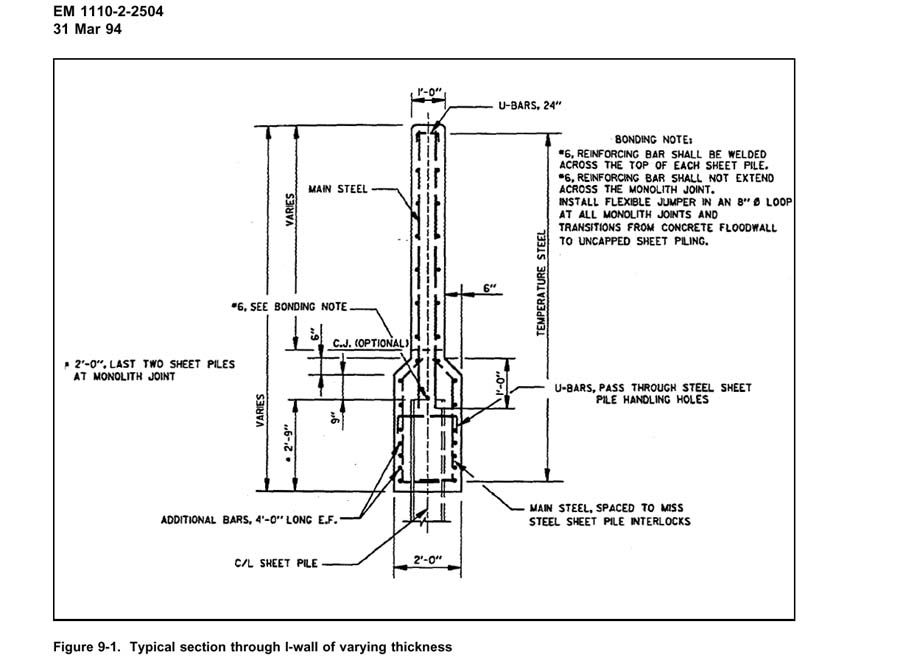
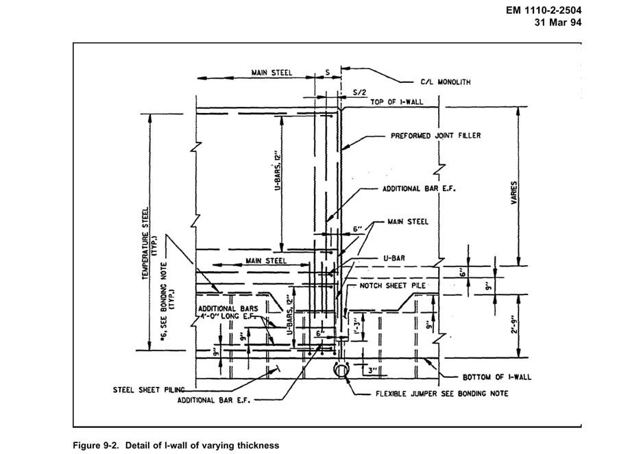
In the case of the 17th Street and London Canal levees, the sheet piles were driven to depths of 17.5 and 16 feet respectively.
The image below is a typical cross section of an earthen levee, similar to the type in service along the northern, eastern, and southern reaches of east Orleans and St. Bernards Parishes.

Generally, the failed sections of earthen levee around St. Bernard and east Orleans Parishes do not appear to have included sheetpiling or other core construction. In a very few instances, evidence of a sheetpile core is now exposed and in general, these occurrences tend to be present where older pre-existing canals and natural waterways cut across the levee's intended location, probably due to recognition that otherwise seepage and percolation would be more of a problem at these locations.
TOPICS: Business/Economy; Crime/Corruption; Culture/Society; Extended News; Front Page News; Government; Miscellaneous; News/Current Events; Politics/Elections; Technical; US: Louisiana; Your Opinion/Questions
KEYWORDS: 229; blanco; canal; canals; corruption; flooding; hurricane; katrina; katrinafailures; landrieu; levee; leveeboard; levees; louisiana; nagin; neworleans; rita; wilma
Navigation: use the links below to view more comments.
first previous 1-20, 21-40, 41-49 last
To: jeffers
I keep coming back to the fact that neither the Orleans Avenue Canal nor Bayou St. John failed. These 2 are between 17th St and London Av, so what was different? The floodgates.
I'm the farthest thing from an engineer, but it seems like neither of these canals would have failed during the surge from the lake if they had been equipped with floodgates similar to the ones on either side of Lake Vista.
41
posted on
11/30/2005 7:59:12 PM PST
by
Mudbug
To: Mudbug
Lake Pontchartrain is directly connected to the London and 17th Street Canal, with no floodgates protecting them. It is common sense then, to conclude that the water level in those canals closely follows water levels in the nearby Lake. By establishing surge height in the nearby Lake, we can establish the surge level in the canals and determine whether the failures occurred below, at, or above design protection levels.
Damage to the Lakefront levees establishes a minimum surge height of 13.5 feet, and in some cases, 18.5 feet above sea level. The US Army Corps of Engineers often proclaimed that the I-Wall design would withstand a storm surge of 11.5 feet, the canal capwalls were subjected to between two and seven feet greater surge height than that, and in three relatively small sections, they failed. If there is a problem with the levee design, it lies with those who approved it, and funded it, not those who were given a monetary figure to work with, designed a structure that could be built for that price, and oversaw construction of it.
Since it will take several years to complete any levee improvements, the current plan is to restore the levees to their pre-Katrina protection levels before next storm season.
If and when levee improvement above those levels begins, I have little doubt that the first projects will include floodgates at the London and 17th Street Canal entrances. There is a basic problem with canal floodgates in a case like this, during storms, the canals are used to transport excess drainage out of the city areas after it is pumped from low lying areas into the canals. If the floodgates at the canal entrances equal the Lake levees in protection levels, then the drainage will have to be pumped over them, some 18.5 feet instead of 14.5 feet ASL.
This is not an insurmountable problem, but it is more costly, and it requires a pumping station nearby.
If I recall, this was the reason given for why the London and 17th Canals did not have floodgates before Katrina. I strongly suspect that will change.
Again though, the USACE does not make these types of decisions. The Louisiana Congressmen and Women float funding bills to the US Legislature, if and when these are passed, the Louisiana State government decides what to do with the money and how to raise any required matching funds, the Corps of Engineers then tells them what level of protection they can provide for that sum, and if the state government agrees to proceed, the CoE then supervises the letting of bids and actual construction work.
This is why a $700 million dollar lock that nobody except a few political cronies wanted was being built in the Industrial Canal while $3.5 million dollars of "emergency lift" funding to raise the levees that were sinking went un-funded.
42
posted on
12/01/2005 4:22:48 AM PST
by
jeffers
To: jeffers; Brilliant; Gumdrop; nuconvert; visitor; Barnyard; carola; 1903A3; babble-on; ...
Reference ping.
Excellent anecdotal account narrowing the time frame of the 17th Street and London Canal breaching here:
http://www.freerepublic.com/focus/news/1589796/posts?q=1&&page=41#41
Analysis (same page as above, scroll down) indicates that the London Canal protection structure failed first, probably between 9:50-11:15, most likely between 11:15 and 11:30, while the 17th Street Canal breach most likely occurred between noon and 12:15, both within hours of the eyewall's closest point of approach.
43
posted on
03/06/2006 10:17:54 PM PST
by
jeffers
To: jeffers
Hi, Jeffers.
The recent national discussion about "breaching vs topping" brought to mind all your great work here.
Thanks again for all you have taught us.
44
posted on
03/07/2006 5:48:49 AM PST
by
syriacus
(Hillary says: Millions to China's state-run shippers; not one RED cent to the UAE shippers)
To: jeffers; NautiNurse
Thanks for the ping, Jeffers. Seems like we just ended last year's hurricane season and stories like these below are already circulating:
Will you be ready for the 2006 hurricane season?
Poll: Most Southeastern residents not ready for 2006 hurricanes.
Upcoming hurricane season looks to be another bad one.
45
posted on
03/07/2006 5:54:10 AM PST
by
bwteim
(Begin With The End In Mind)
To: jeffers; Saints fan
The begining of some relevant conclusions from reply 6 below.
..Summary, conclusions, and projections:
These are the reasons why St. Bernards Parish flooded, as evidenced above.
1. The levees sank into the marsh.
2. The money to fix the sunken levees was instead spent on airports, marinas, promenades, and fountains, with the great bulk of all funding being directed towards a lock that benefits a very few shipping companies...
Seems like it's getting clearer where the responsiblity lies. The Federal Government rather then "Destroying New Orleans", shipped money down by the trainload for flood protection. The state and local leaders just decided to party the money away.
46
posted on
03/07/2006 6:23:55 AM PST
by
Jack of all Trades
(Liberalism: replacing backbones with wishbones.)
To: Fierce Allegiance
Thanks for the ping. How have you been?
47
posted on
03/07/2006 12:58:09 PM PST
by
JimWforBush
(Setec Astronomy)
To: jeffers
Thanks again, for both the material and the ping. This is great work, Jeffers!
Do you have all this archived in one place somewhere on the web, or are the posts FR exclusives?
48
posted on
03/07/2006 10:52:27 PM PST
by
umbagi
(Monthly Donor [entry level])
To: jeffers
Thanks for the ping!
More very excellant work on your part it seems!
49
posted on
03/08/2006 11:33:35 AM PST
by
Bigun
(IRS sucks @getridof it.com)
Navigation: use the links below to view more comments.
first previous 1-20, 21-40, 41-49 last
Disclaimer:
Opinions posted on Free Republic are those of the individual
posters and do not necessarily represent the opinion of Free Republic or its
management. All materials posted herein are protected by copyright law and the
exemption for fair use of copyrighted works.
FreeRepublic.com is powered by software copyright 2000-2008 John Robinson