To: palmer; tertiary01
Comparing ice cores to CO2 measurements made other ways like in the atmosphere is silly.I completely disagree.
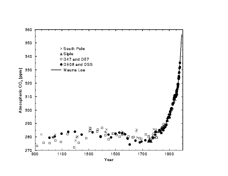
I'm not sure what DE08 and DSS are, but all of the other points are from ice cores. The black line is the Mauna Loa atmospheric CO2 measurement curve.
This figure shows it a little better. There's another better one that I can't seem to find at the moment.

To: cogitator; tertiary01
Your pictures are highly deceptive. They imply ice core resolution that is simply impossible in any sample other than a modern (uncompacted) one. The first one overlays measurements so you can't even see if there any ice measurements underneath (not that they matter). The second is pretty lacking, I'm sure you can find better. In the meantime, here's a better source, showing error bars on most of the samples. Note the absence of a hockey stick.
28 posted on
06/27/2006 10:56:24 AM PDT by
palmer
(Money problems do not come from a lack of money, but from living an excessive, unrealistic lifestyle)
FreeRepublic.com is powered by software copyright 2000-2008 John Robinson