Skip to comments.
Chinese black helicopters circle Google Earth
The Register ^
| Wednesday 19th July 2006
| Lester Haines
Posted on 07/29/2006 8:59:17 AM PDT by Dog Gone
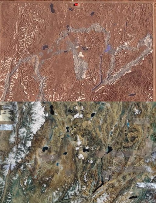
Those among you who like your skies darkened by black helicopters are invited to mosey on down to the remote Chinese village of Huangyangtan which hosts what must be the strangest military installation ever spotted (http://bbs.keyhole.com/ubb/showthreaded.php/Cat/0/Number/484568/page/vc) by the Google Earth Community:

Zooming in for a closer look, we have what appears to be a 900x700m scale model of a mountainous landscape...

...complete with lakes, valleys and snow-capped peaks:

Truly bizarre. Google Earth aficionados can examine the evidence for themselves here (http://regmedia.co.uk/2006/07/19/huangyangtan.kmz) (.kmz) while wondering what on Earth, or where on Earth for that matter, this remarkable landscaping project is.
Don't, however, spend the next three days scouring the world's mountain ranges trying to find a geographical match: the legwork has already been done for you by this (http://bbs.keyhole.com/ubb/showthreaded.php/Cat/0/Number/510687/page/vc/vc/1) enterprising Google Earth Community member who correctly identified the model as representing this (http://regmedia.co.uk/2006/07/19/aksayqin_hu.kmz) disputed area on the Chinese/Indian border.
Here's a comparison of the Chinese model and the Google Earth image of the region in question...
...while a closer look reveals the meticulous attention to detail:
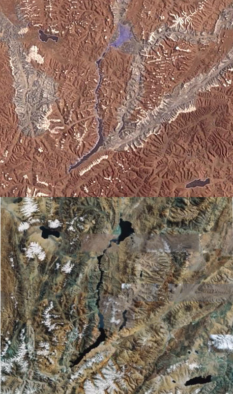
It's clear that a huge amount of time and resources has been invested in this perplexing scale model, which incidentally represents an area of around 450 by 350 kilometers. The big question is: why?
The only sensible explanation we can come up with is that it's a training aid for pilots - possibly helicopter jockeys - designed to familiarise them with the landscape should military action ever be required.
No doubt you lot can come up with some better suggestions, but while you ponder this mystery keep one eye open for the black helicopters of Huangyangtan. ®
TOPICS: Miscellaneous
KEYWORDS: china; chinesemilitary; google; googleearth; satellites; trainingcamps
Navigation: use the links below to view more comments.
first 1-20, 21-40, 41-59 next last
Google Earth is awesome.
And this Chinese facility is bizarre. It's not for helicopter training. I think that was an attempt to be funny.
But why did they build it?
1
posted on
07/29/2006 8:59:17 AM PDT
by
Dog Gone
To: Dog Gone
It's training tool for armed forces. works very well with visual learners. this is one huge country
2
posted on
07/29/2006 9:02:14 AM PDT
by
Cinnamon
To: Dog Gone
Slave labor is amazing... You should see what the Chinese can do with stolen body parts from young women and children... now that is incredible...
The Chinese prince class is evil.
3
posted on
07/29/2006 9:03:10 AM PDT
by
Porterville
(Hispanic Republican American Bush Supporter)
To: Dog Gone
But why did they build it? For some reason, the plot of the recent Oceans 11 remake comes to mind.
4
posted on
07/29/2006 9:03:18 AM PDT
by
JennysCool
(Roll out the Canarble Wagon!)
To: Cinnamon; Dog Gone
But why not just use google earth as the training aide? We do...
5
posted on
07/29/2006 9:05:09 AM PDT
by
patton
(LGOPs = head toward the noise, kill anyone not dressed like you.)
To: Dog Gone
Perhaps it's me but I don't see anything but undeveloped terrain.
6
posted on
07/29/2006 9:06:25 AM PDT
by
nmh
To: Dog Gone
Perhaps they want to get the 3d views using helicopter models.
But the scale still doesn't work.
7
posted on
07/29/2006 9:07:41 AM PDT
by
BobL
To: nmh
8
posted on
07/29/2006 9:07:49 AM PDT
by
Dog Gone
To: Dog Gone
Google Earth is awesome.
It really is...I just installed it two weeks ago, now that I'm on broadband; still have a bit to learn about it, tho...
9
posted on
07/29/2006 9:08:24 AM PDT
by
ErnBatavia
(Meep Meep)
To: nmh
Look at the first picture. They're talking about a mountain range the size of a building.
IMO, it's not a "real" scale model but some kind of fake picture or graphic designed to cover up a sensitive military base.
10
posted on
07/29/2006 9:09:07 AM PDT
by
Seamoth
(Kool-aid is the most addictive and destructive drug of them all.)
To: Seamoth
And GoogleEarth.com, doing the bidding of their slave masters in Peiping have dutifully replaced the ACTUAL PHOTO of that area with a FAKE PHOTO worked up by the Chicoms.
Wonder who else GoogleEarth.com works for and how much they get paid.
11
posted on
07/29/2006 9:12:06 AM PDT
by
muawiyah
(-/sarcasm)
To: muawiyah
well, while I hate that Google is cooperating with the Chicoms on the censorship, these satellite images clearly come from a public database of some sort (I know Google's rich but I doubt they have a satellite taking all those pictures). In that case, all China has to do is feed bad pictures to the database and refuse to supply real pictures to it, and I'm sure they have some kind of technology to fool satellites on their end too. I doubt Google is to blame here.
12
posted on
07/29/2006 9:17:28 AM PDT
by
Seamoth
(Kool-aid is the most addictive and destructive drug of them all.)
To: Seamoth
It is a real scale model. There's no denying that.
It's from the border of Kashmir and China. If you have Google Earth, you could go check for yourself using the links in this story. The "mountains" at this site are only about 4 feet high at most, but it's no photo.
13
posted on
07/29/2006 9:18:21 AM PDT
by
Dog Gone
To: Jeff Head
14
posted on
07/29/2006 9:19:27 AM PDT
by
Incorrigible
(If I lead, follow me; If I pause, push me; If I retreat, kill me.)
To: Seamoth
Maybe, but why so obvious and making it stand out? That only invites our real satellites to take a peak.
Unless they are testing our capability to discover the change.
But even with that, how would they know when we (i.e., military) actually discover it?
Disregard above question, they probably found a Democrat working at NSA.
15
posted on
07/29/2006 9:21:18 AM PDT
by
BobL
To: Seamoth
Look at the first picture. They're talking about a mountain range the size of a building.
IMO, it's not a "real" scale model but some kind of fake picture or graphic designed to cover up a sensitive military base.
In the first picture I see a base or some buildings but the other close ups look like typical mountain ranges.
16
posted on
07/29/2006 9:21:49 AM PDT
by
nmh
To: Seamoth
Look at the first picture. They're talking about a mountain range the size of a building.
IMO, it's not a "real" scale model but some kind of fake picture or graphic designed to cover up a sensitive military base.
In the first picture I see a base or some buildings but the other close ups look like typical mountain ranges.
Much to do about nothing ... .
17
posted on
07/29/2006 9:22:07 AM PDT
by
nmh
To: muawiyah
That's about the most bizarre conspiracy theory I've ever heard.
Why wouldn't they replace the actual photo with one like the surrounding empty landscape?
18
posted on
07/29/2006 9:23:13 AM PDT
by
Dog Gone
To: Dog Gone
Because they made a mistake. The Chicoms are not, as it were, perfect~
19
posted on
07/29/2006 9:31:38 AM PDT
by
muawiyah
(-/sarcasm)
To: Dog Gone
They help China catch dissidents too and absolutely refuse to help the US look for terrorists online.
patriotic huh?
20
posted on
07/29/2006 9:32:08 AM PDT
by
GeronL
Navigation: use the links below to view more comments.
first 1-20, 21-40, 41-59 next last
Disclaimer:
Opinions posted on Free Republic are those of the individual
posters and do not necessarily represent the opinion of Free Republic or its
management. All materials posted herein are protected by copyright law and the
exemption for fair use of copyrighted works.
FreeRepublic.com is powered by software copyright 2000-2008 John Robinson