Skip to comments.
Calculated trajectory of Japan nuclear plume over America using the NOAA HYSPLIT model
University of Maryland ^
| 21 March 2011
Posted on 03/21/2011 8:08:07 PM PDT by Milhous
Today's Trajectories
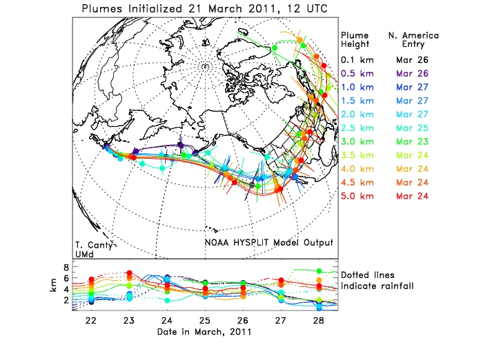
Air parcel trajectories found using the NOAA HYSPLIT model, as a function of plume height, for release over the Fukushima power plant. Each figure corresponds to release on the indicated date. The top panel of shows the forecast projection of the plumes, with each circle representing a 24 hr period of time. The uncertainty in location is represented by the line segments drawn through each circle (these uncertainties are difficult to estimate at later portions of the trajectory).
The bottom panel of shows the forecast altitude of the trajectory. Dotted lines indicate where rainfall occurs.
The entry point into North America of each trajectory is indicated.
The concentration of hazardous material is greatly reduced by mixing along the trajectories. In addition, most hazardous materials are removed by rainfall
TOPICS: News/Current Events
KEYWORDS: fallout; fukushima; japan; kookalert; nuclear
Navigation: use the links below to view more comments.
first previous 1-20, 21-34 last
To: CrazyIvan
To: Milhous
The map shows clearly why Obama is in South America.
22
posted on
03/21/2011 8:56:17 PM PDT
by
mlocher
(Is it time to cash in before I am taxed out?)
To: potlatch; devolve
 Selected for the 2004 National Film Registry of "culturally, historically and aesthetically significant" motion pictures.
Famous Civil Defense film for children in which Bert the Turtle shows what to do in case of atomic attack.
23
posted on
03/21/2011 8:58:35 PM PDT
by
Milhous
(Lev 19:18 Love your neighbor as yourself.)
To: mlocher
An A+ for you! Nancy Pelosi’s coincidentally MIA from the continent too.
24
posted on
03/21/2011 9:01:31 PM PDT
by
Milhous
(Lev 19:18 Love your neighbor as yourself.)
To: potlatch
.
It’s like a really bad sunburn
But 0bama will tax anyone that gets a tanning from it
.
25
posted on
03/21/2011 9:02:44 PM PDT
by
devolve
(. . . . . . . . . . . . "- we*ll bring a gun!" . . . . Fill your hand! . . .)
Hillary’s also MIA from the continent.
26
posted on
03/21/2011 9:05:54 PM PDT
by
Milhous
(Lev 19:18 Love your neighbor as yourself.)
To: Milhous
Nancy Pelosi’s coincidentally MIA from the continent too.LOL! -- but, she was feeling "unwell".
27
posted on
03/21/2011 9:06:55 PM PDT
by
mlocher
(Is it time to cash in before I am taxed out?)
To: devolve
28
posted on
03/21/2011 9:14:28 PM PDT
by
freejohn
To: CrazyIvan
Is that just for Illinois? Trace radiactive iodine has been recorded in Washington state.
To: CrazyIvan
I don’t know what that is, but I’ll bet Doc does. We’re
both from the “duck and cover” generation.
LMAO.
I renumber all those drills too
30
posted on
03/21/2011 9:35:57 PM PDT
by
NoLibZone
(Impeach Obama & try him for treason / Homosexuals reject diversity / Unions finally caught for theft)
To: Cold Heart
I started running a background with my HPGe detector last Friday.
This morning a low confidence Cs-134 peak showed up above MDA. Not enough to call it yet.
31
posted on
03/21/2011 10:03:20 PM PDT
by
seowulf
("If you write a whole line of zeroes, it's still---nothing"...Kira Alexandrovna Argounova)
To: Cold Heart
Oh, by the way, I heard on NHK English tonight that seawater samples near the plants showed I-131, Cs-134, and Cs-137 (typical fission products).
32
posted on
03/21/2011 10:07:33 PM PDT
by
seowulf
("If you write a whole line of zeroes, it's still---nothing"...Kira Alexandrovna Argounova)
To: Milhous
Personally I won’t put much stock in a chart from a state university, The so called scientists that created it probably created a bunch of global warming charts for the Democrat party.
33
posted on
03/22/2011 3:12:36 AM PDT
by
ReformedBeckite
( post 1 of 3 I'm only allowing my self each day)
To: ReformedBeckite
NOAA produces short range (a few days) WX forecasts for the US and Canada. Aviation pilots use NOAA products to choose between Visual Flight Rules or Instrument Flight Rules. Local TV news uses NOAA forecasts for weather forecasting.
34
posted on
03/22/2011 7:52:01 AM PDT
by
Milhous
(Lev 19:18 Love your neighbor as yourself.)
Navigation: use the links below to view more comments.
first previous 1-20, 21-34 last
Disclaimer:
Opinions posted on Free Republic are those of the individual
posters and do not necessarily represent the opinion of Free Republic or its
management. All materials posted herein are protected by copyright law and the
exemption for fair use of copyrighted works.
FreeRepublic.com is powered by software copyright 2000-2008 John Robinson