
Posted on 09/11/2018 12:04:03 PM PDT by Pollard
Airforce Hurricane made it's pass this morning and the NHC has updated it's forecast.
Regardless of technical terminology, someone really needs to work on their sentence structure, LOL. Looks like it's not strengthening all that much and will spin down quick once making landfall.
Hurricane Florence Discussion Number 49
NWS National Hurricane Center Miami FL AL062018
1100 AM AST Tue Sep 11 2018
Data from satellites and an Air Force Reserve reconnaissance aircraft mission indicate that Florence has completed an overnight eyewall replacement cycle (ERC). The recon data indicate that the eye has now expanded to a diameter of 30-32 n mi, and this was confirmed by an 1103Z SSMI/S microwave satellite image. The aircraft provided various intensity estimates with a peak SFMR surface wind of 113 kt noted in the northwest quadrant, a peak 700-mb flight-level wind of 143 kt in the northeast quadrant, and a central pressure of 950 mb. The 143-kt flight-level wind would normally correlate to an equivalent surface wind of about 129 kt. However, coincident SFMR surface winds were only 108 kt, indicating that the weak convection that region of the hurricane was not vigorous enough to bring down the strongest winds to the surface. The 950-mb central pressures corespondents to about 113 kt. Based on a blend of all these data, the initial intensity has been set to 115 kt.
The initial motion estimate is now 295/14 kt based on the recent recon fix data. The broken record continues -- there is no significant to the previous track forecast or reasoning. Although the global and regional models continue to make minor shifts northward and southward, the consensus models have changed little. GOES-16 high-resolution water vapor imagery indicates that the amplifying large-scale flow pattern across CONUS is inducing a downstream ridge over the western Atlantic, with a high pressure cell centered northwest of Bermuda. This blocking ridge pattern is expected to keep Florence moving west-northwestward to northwest at around 15 kt for the next 48 hours or so. However, embedded within the large-scale flow is a weak shortwave trough over the central and southern Plains that is expected to eject out northeastward and weaken the ridging across the mid-Atlantic and southeastern U.S., causing Florence to slow down significantly in 72 hours as the powerful hurricane approaches the Carolinas. On days 4 and 5, an even slower motion or drift to the west and northwest is forecast, which will exacerbate the heavy rainfall threat. The new NHC forecast track is just an update of the previous one, and basically lies the middle of the guidance envelope between the consensus models TVCA to the north and HCCA and FSSE to the south.
Water vapor imagery indicates that Florence has finally developed the much anticipated dual outflow pattern, with outflow jets noted in the northwestern and eastern quadrants. The latter outflow jet is flowing into an upper-level low, which is acting as an impressive mass sink near 25N/49W. These two outflow channels are producing significant deformation stretching across Florence's inner-core, which should aid in the re-strengthening process. Now that the eye has become stable with a diameter of about 30 n mi and since Florence is expected to remain in a low-shear environment of around 5 kt and over above-average SSTs of 29.0-29.5 deg C, slow but steady strengthening is expected for the next 24-36 hours. By 48 h and beyond, Florence's slow forward speed, coupled with the large eye and relatively shallow depth of the warm water should induce some upwelling beneath the cyclone that will initiate a slow weakening trend. By 72 hours the vertical wind shear is expected to increase to near 20 kt from the southwest, which will cause more significant weakening to occur. However, given the large overall wind field of Florence along with the large eye, only gradual weakening is expected. Once Florence moves inland, the slow forward speed of 3-5 kt will result in rapid spin down and weakening of the wind field. The new official intensity forecast is above of all of the intensity guidance based on the aforementioned very favorable synoptic outflow pattern, and to maintain continuity with the previous forecast.
Key Messages:
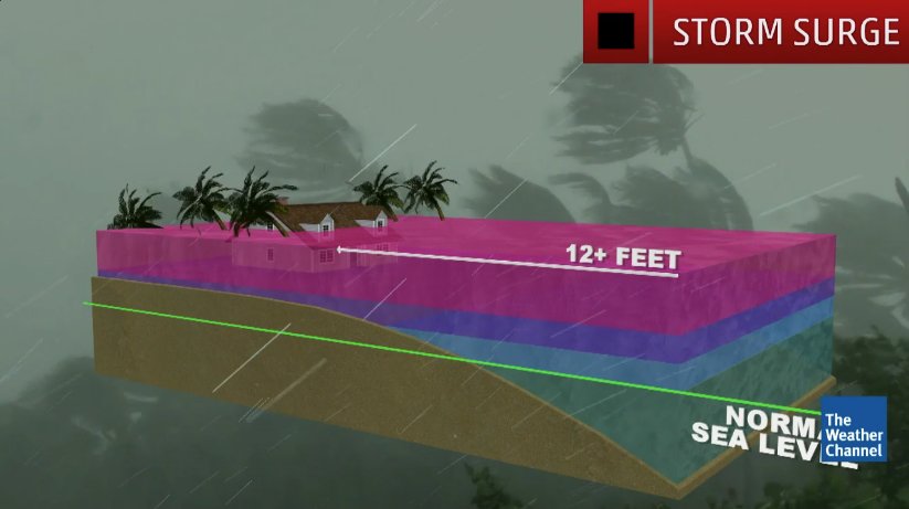
1. A life-threatening storm surge is likely along portions of the coastlines of South Carolina, North Carolina, and Virginia, and a Storm Surge Watch is in effect for a portion of this area. All interests from South Carolina into the mid-Atlantic region should ensure they have their hurricane plan in place and follow any advice given by local officials.
2. Life-threatening, catastrophic flash flooding and significant river flooding is possible over portions of the Carolinas and Mid-Atlantic states from late this week into early next week, as Florence is expected to slow down as it approaches the coast and moves inland.
3. Damaging hurricane-force winds are likely along portions of the coasts of South Carolina and North Carolina, and a Hurricane Watch is in effect for a part of this area. Damaging winds could also spread well inland into portions of the Carolinas and Virginia.
4. Large swells affecting Bermuda and portions of the U.S. East Coast will continue this week, resulting in life-threatening surf and rip currents.


Still a good size hurricane and will dump a lot of rain in a short amount of time but it's probably not going to be as bad as expected early on. There's just no way to forecast a hurricane 6-7 days out.
Let me know when the politicians start putting on their hip boots.
The last EURO run shows landfall in NC and then it turns southwest and proceeds down the coast to about Charleston. Maybe the EURO is smoking weed but I hate to discount a model that is generally accurate.
It will be raining so hard the pols will have to keep their hands in their own pockets.
That is consistent with the general trend in other models. Euro is just more pronounced in taking it so far to the SW. If it or something close to it comes to pass, it will be catastrophic for a long stretch of coastline, but would also generate less pronounced inland flooding.
I live in Central VA and getting out of dodge. Lots of fallen trees and power outages.
I live on Eastern Shore of Maryland...so far doesn’t look too bad for us, but crossing the Bay Bridge might be iffy. Too bad and they will probably close it down.
Let’s pray The God of Israel knocks this puppy out the way He saved Hawaii!
Most of the models have it turning away from Virginia, especially the European ones (orange). I’m in north western NC and don’t foresee any great danger, thus far.
https://apps.sfwmd.gov/sfwmd/common/images/weather/plots/storm_06.gif
in the Carolinas, says research by Dr. Jeff Masters of Wunderground.


boarding up and taking this hurricane seriously...
even providing information for others in the area


Would like any thoughts on why this graph of catastrophic flooding has not changed from when Florence was to hit at a Cat 4 and head north to northwest.
Disclaimer: Opinions posted on Free Republic are those of the individual posters and do not necessarily represent the opinion of Free Republic or its management. All materials posted herein are protected by copyright law and the exemption for fair use of copyrighted works.