
Posted on 01/19/2008 3:41:43 AM PST by Fred Nerks
These structures resemble Plato’s description of Atlantis, except for being on dry land.
http://www.philipcoppens.com/nap_art5.html
Might need a little grain of salt, but it’s the only website that provides any detail worth the read:
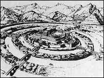
“...According to translations of ancient Nahuatl, Cuicuilco can be interpreted as the “place of prayer” or the “place of the rainbow”. Cuicuilco was as a farming village, built up around the ceremonial centre that contained the pyramid. Population at the city’s peak is estimated at an impressive 20,000 people.
Cuicuilco is, as mentioned, recognised as the oldest known civilisation of central highland Mesoamerica...”
Now, I want to know what it was that gave people the idea to follow such a similar layout on three continents...was it something they saw overhead?
This image of a structure on one of the Orkney Islands intruiges me. Based on concentric circles, central hub and entering pathways layout - we can actually see how much of the original was 'snapped off' and disappeared into the sea:

Another pyramid book..... At Blam’s recommendation i bought Voyages of the the Pyramid Builders
I’ll start it next week on my winter vacation.
This one looks pretty good.
Could be any of a number of things including some of the symbology of ancient and forgotten mystery religions, which we wouldn’t know about in any detail since it was—forgotten. Something we see fairly often in the sky is a rainbow circle around the sun or the moon when the atmosphere is right for that.
The article was so good I read it twice!
Glad you enjoyed it...informative and beautifully written, wasn’t it?
“The riddle of Rogem Hiri remains unsolved. Those who built it some 5,000 years ago left the stage of history and took with them the secrets of this unusual site.”
Perhaps, we need to look outside the box for a solution. Often there are clues in site names which although corrupted over time, give us a glimpse into the past.
For example, look at the current name identifying the site. “Rogem” clearly is a third person variation or command of the verb, “to roger” (Something the Arabs are very fond of I understand.)
Therefore one could read the name as a command to ‘roger ‘em hiri’ making the site a vast playground where psychosexual dramas were acted out.
For further proof of this theory one only has to look at the aerial photo view of the site in which the central point looks suspiciously like a ...(I won’t go there in the interests of delicacy and decorum)

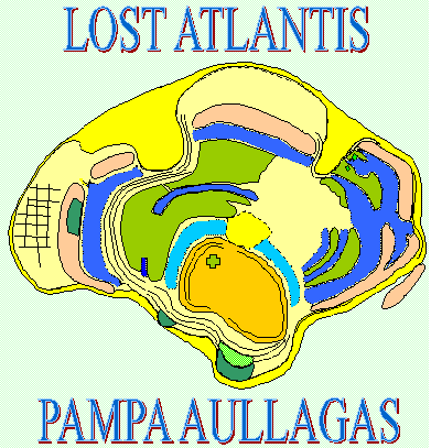
"The main premise in this book is that there are enough distinct threads of evidence to support the theory that the proto-civilization for many of the notable cultures of the past (such as the ancient Egyptions, Mayans, and so on) was based in a time when the sea-levels were much lower in a region called "Sundaland". This region is now mainly underwater due to glacial melting since the last Ice Age and stretches from Indochina to Borneo and Timor."
" Schoch uses a myriad of types of circumstantial evidence such as commonality of flood myths, linguistic comparisons, genetics, geologic, tree-ring data, archeological remains, ancient math and astronomical knowledge, and so forth to piece together support for his theory. Some of it is robust, some of it is a bit tenuous, but all in all, I find it worth considering.
Whoops! And thanks Calpernia!
Thanks Fred for the additional graphics, and wildbill for the naughty bits.
Solving the Mystery of a Megalithic Monument in the Land of Giants [Popular Archaeology]
|
|
|
| GGG managers are SunkenCiv, StayAt HomeMother & Ernest_at_the_Beach | |

|
|
Original topic is from 2008. |
|
|
|
|
Innerestin’.
Oh yeah, and how was that dated, huh? You use that carbon 18 or something?
“Buckingham Nicks”
I’ve been looking all over for that CD.
My theory is that it’s an ancient recreation center.
-Great name! “Og”-
“Og” is my middle name!
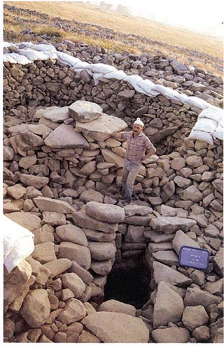
Rogem Hiri (“Mound of the Wild Cat”) is the Arabic name for this site, and Gilgal Refaim* (“Wheel of Refaim”) is the Hebrew name. It is situated in the Golan Heights (Israeli occupied Syria) , 16 kms east of the Sea of Galilee, in the middle of a large plateau (32.908388°N 35.800581°E). Nearby there are also hundreds of dolmens.
It is made from an estimated 42,000 basalt rocks. There is no mystery as to how they built it, but it would’ve been quite an effort. The four concentric rings range from 50m in diameter and 1.5m wide for the innermost, to 150m in diameter and 3.2m wide for the outermost ring.
At the very centre is a tomb, although the burial occurred much more recently (roughly 1400BC) than the construction of the site itself (2500-3000BC). And of course, the tomb has been looted, so it is merely presumed someone was buried there…
At the center of the circles is a cairn, an irregular heap of stones. It is 20-25 m. in diameter and preserved to a height of 6 m. The cairn consists of a central mound of stones surrounded by a lower belt, which gives it the appearance of a stepped, truncated cone. A geophysical survey using Ground Penetrating Radar (GPR) revealed the pile of stones to be hollow. A built burial chamber, with a narrow corridor leading to it, was discovered there. The chamber is round, roughly 2 m. in diameter, built of large stone plates arranged on top of each other, but slightly slanting inwards. It was covered by two massive slabs of basalt, each weighing over 5.5 tons, which created a semi-corbelled dome over the burial chamber.
Disclaimer: Opinions posted on Free Republic are those of the individual posters and do not necessarily represent the opinion of Free Republic or its management. All materials posted herein are protected by copyright law and the exemption for fair use of copyrighted works.
![Solving the Mystery of a Megalithic Monument in the Land of Giants [Popular Archaeology]](http://popular-archaeology.com/upload/2697/gilgalrefaim1.jpg)