
Posted on 08/26/2017 4:39:50 AM PDT by NautiNurse
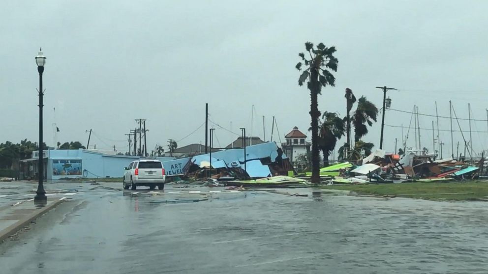
Hurricane Harvey made landfall near Rockport TX about 10:00PM CDT Friday night. Top sustained winds were 130mph. Rockport High School sustained heavy damage when a portion of the roof collapsed. A senior housing complex collapsed. The Rockport courthouse sustained major damage with “a cargo trailer halfway in the building.” Multiple tornadoes reported in the Houston/Galveston areas. There are reports of scattered structural fires and a shooting was reported in Corpus Christi. Residents along the San Bernard River were advised to evacuate and most TX Gulf coast counties are under flash flood watches.
Many locations are under a boil-water notice. Power outages are widespread. President Donald Trump promptly granted a Disaster Declaration to Texas Governor Greg Abbott’s request. More than 700 members of the Texas Army and Air National Guards, Texas State Guard and the Texas Military Department have been activated and are positioning themselves throughout the state ahead of Hurricane Harvey and its anticipated landfall later this week. Ahead of the storm, FEMA sent supplies from its warehouse in Fort Worth to a staging point at Randolph Air Force Base near San Antonio.


Mash image to find lots of satellite imagery links
Public Advisories
Severe Weather Watches and Warnings TX
NHC Discussions
NHC Local Hurricane Statements Corpus Christi
NHC Local Hurricane Statements Galveston
Buoy Data near Harvey
Thread I: Potentially Catastrophic Hurricane Harvey Approaches Texas Gulf Coast
Checking in from Seabrook on Galveston Bay and we’re doing fine. Front and back yards were above the ankle wet this morning but have drained off some. The bayfront water covered the beach but hasn’t begun to climb the hill. Off and on light rain today.
Been listening about Rockport......very difficult for rescuers to get around much to speak of ..lines are down everywhere not to mention trees and loads of flooded roads. But this isn’t over yet either....
12z GFS is more west and a weaker system
12z EURO takes it back over the water and moves it back towards houston by days 4-5
in the short term expect heavy rain rates to increase around the center overnight..
but I am still most concerned about the Houston metro area
3-10 inches already
models have convergence increasing overnight and into sunday in the NE dirty side
this will set up training band similar to day
since the bands are moving fast you wont get the 4-5 inch rates in a short period of time..but 1-2 inches rates over and over again
then if the EURO is right another center/eye in a couple of days with the heavy rates
keep in mind the upwelling from the wind is cooling off the shallow waters just offshore....so the bath water(ie 86-89F) is gone now in the 80-84 range ..still warm enough to restrengthen if harvey moves back offshore
Great Girlscout.
Some of the heavy structural damage to larger buildings does not look like hurricane damage, it looks like tornado damage. You wouldn’t see a large gaping hole through the middle of a long multistory brick apartment building with either end largely intact from a hurricane, you’d see the windward side stripped of roofing, the eaves and possibly the entire roof deck torn off, one or two sides of brick fallen off and many if not most of the windows that weren’t boarded up broken out with hurricane damage. If the hurricane was strong enough, the whole building would have collapsed. So, I’m pretty sure there was at least one pretty strong tornado that went through Rockport along with the hurricane, myself.
Nothing so far. Am waiting.
likely small meso vortices in the eyewall enhancing damage in local spots

I agree with you- much of what I’ve seen on the YouTube videos is tornado damage. Thinking more than one.
Tornadoes were the cause of much of the horrible damage from Andrew in South Florida.
The electric utility needs to cut power at any substation serving damaged areas for public safety and rescue efforts. This is Texas so I’m sure they know that but it’s been a long time since they’ve been hit, maybe that knowledge was lost with retirements or something. People living in houses that weren’t much affected will be irritated no doubt, but it’s got to be done.

Cattle in a flooded field near Rockport, Tex., on Saturday.

Thanks for local update!
Those fairly neat piles in a row of mixed debris from a variety of places is from storm surge.

Good news—glad you are faring well. Thanks for your update.
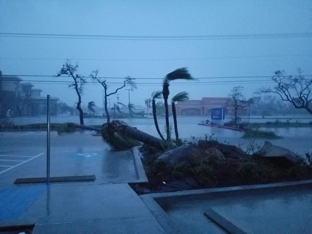
Live Oaks and Sabal Palms are very wind and salt hardy. They’re going to look rough for a while but they’ll come back good as ever in a year or two, provided they weren’t hit with heavy overwash from the surge. Even highly salt tolerant coastal species won’t survive being submerged in salt water.
MESOSCALE PRECIPITATION DISCUSSION 0737
NWS WEATHER PREDICTION CENTER COLLEGE PARK MD
238 PM EDT SAT AUG 26 2017
AREAS AFFECTED...SOUTHEAST TX INTO SOUTHWEST LA
CONCERNING...HEAVY RAINFALL...FLASH FLOODING LIKELY
VALID 261840Z - 262245Z
SUMMARY...BANDING ASSOCIATED WITH TROPICAL STORM HARVEY WILL
CONTINUE TO AFFECT PORTIONS OF SOUTHEAST TX INTO SOUTHWEST LA
THROUGH THE LATE AFTERNOON AND EARLY EVENING. SIGNIFICANT FLASH
FLOODING IS EXPECTED WHERE THE BANDING PERSISTS.
DISCUSSION...THE GOES-16 IR CLEAN LOOP SHOWED THE BEST BANDING
ASSOCIATED WITH HARVEY OVER THE UPPER TX COAST AND A PORTION OF
SOUTHWEST LA...AND THIS IS CONFIRMED BY REGIONAL RADARS. THE KHGX
RADAR SHOWED HOURLY RAINFALL RATES BETWEEN 1.50 AND 2.50 INCHES
ASSOCIATED WITH THE BEST BANDING BETWEEN HOUSTON TX AND LAKE
CHARLES LA.
THE BANDING FEATURES EXTEND OVER THE GULF OF MEXICO AS WELL...AND
THE TRAJECTORY FOR THE ELONGATED BAND APPEARS TO BE OVER PORTIONS
OF THE UPPER TX COAST DURING THE AFTERNOON HOURS. THE LOW LEVEL
CYCLONIC FLOW (PER REGIONAL VWP) IS EXPECTED TO FOCUS THESE BANDS
ON THE EASTERN SIDE OF THE CIRCULATION....WHICH WILL EXTEND INTO
PORTIONS OF SOUTHWEST LA. PORTIONS OF SOUTHWEST LA HAVE ALREADY
RECEIVED THEIR AVERAGE YEARLY RAINFALL...AND REMAINS SENSITIVE TO
ADDITIONAL HEAVY RAINFALL.
THERE IS A SOLID HIGH RESOLUTION MODEL SIGNATURE (LED BY THE MOST
RECENT HRRR) FOR ADDITIONAL RAINFALL AMOUNTS BETWEEN 4.00 AND 8.00
INCHES BETWEEN KLBX AND KBPT... AND THIS LOOKS REASONABLE BASED ON
THE CURRENT POSITIONING OF THE BANDING ON SATELLITE AND RADAR. THE
ADDITIONAL RAINFALL IS EXPECTED TO PRODUCE SIGNIFICANT FLASH
FLOODING WHERE BANDING PERSISTS... ESPECIALLY IF THE BANDING
AFFECTS THE HOUSTON METRO AREA.
AS THE BANDS DRIVE FURTHER INLAND...FLASH FLOODING COULD BECOME A
CONCERN AS FAR NORTH AS KUTS AND SOUTH OF KLFK.

Bookmark
Disclaimer: Opinions posted on Free Republic are those of the individual posters and do not necessarily represent the opinion of Free Republic or its management. All materials posted herein are protected by copyright law and the exemption for fair use of copyrighted works.
