
Posted on 08/26/2017 4:39:50 AM PDT by NautiNurse
Hurricane Harvey made landfall near Rockport TX about 10:00PM CDT Friday night. Top sustained winds were 130mph. Rockport High School sustained heavy damage when a portion of the roof collapsed. A senior housing complex collapsed. The Rockport courthouse sustained major damage with “a cargo trailer halfway in the building.” Multiple tornadoes reported in the Houston/Galveston areas. There are reports of scattered structural fires and a shooting was reported in Corpus Christi. Residents along the San Bernard River were advised to evacuate and most TX Gulf coast counties are under flash flood watches.
Many locations are under a boil-water notice. Power outages are widespread. President Donald Trump promptly granted a Disaster Declaration to Texas Governor Greg Abbott’s request. More than 700 members of the Texas Army and Air National Guards, Texas State Guard and the Texas Military Department have been activated and are positioning themselves throughout the state ahead of Hurricane Harvey and its anticipated landfall later this week. Ahead of the storm, FEMA sent supplies from its warehouse in Fort Worth to a staging point at Randolph Air Force Base near San Antonio.


Mash image to find lots of satellite imagery links
Public Advisories
Severe Weather Watches and Warnings TX
NHC Discussions
NHC Local Hurricane Statements Corpus Christi
NHC Local Hurricane Statements Galveston
Buoy Data near Harvey
Thread I: Potentially Catastrophic Hurricane Harvey Approaches Texas Gulf Coast
FYI the Harris county rainfall map also has the Reservoir elevations..they emptied them out a couple of days ago..but filling up fast now
https://www.harriscountyfws.org
move you Mouse over each station and click more info
With a metal roof, always start laying the pieces on the opposite side from your normal wind blow. That way, if the edge piece comes off, it won’t pull the rest of the roof with it.
Yup, heavy rains and winds. Be safe, FRiend.
FEMA will need millions of vacuums to deal with the Corgi hair.
The lying weathermen are one uping each other. The latest was an Austin guy in Corpus who claimed when they went out this morning, the cops were immediately all up in their faces with questions. Up in their faces, his words. Sure, as if the tv crew weren’t wearing their tv station jackets and lugging their equipment with logos stamped all over.
Our friends were luckier on the NW of Houston. They say they’re fine but who knows what the night will bring.
Trying to lay or lap with prevailing wind is typical with all roofing. The true issue is that the lap connection or stitching screws in any good wind-uplift standard will still cause the whole roof to peal very often when you loose a full eave trim and first sheet in many tornados.
Attention to details, such as the one you suggest, is everything in durable construction.
Huh? In the case of Katrina, everyone with any sense at all knew the likelihood of a disaster was high, 2-3 days out. Certainly most of us who are severe weather buffs recognized the danger. This is called “imminent threat”, and an imminent threat can be anything from seconds away to a year or more, depending on the scale of the threat and what it takes to neutralize it. (If a sizeable (ELE) asteroid was spotted heading toward Earth, a year away, that’s an imminent threat, in my book, and hopefully the government’s too!)
In the case of Katrina and the buses (sounds like a spoof rock band!), if the gov’t used the buses for other purposes than evacuation / rescue, etc., then the owners would have grounds to sue. The same goes if a police officer commandeers my car to catch a dangerous criminal, and then uses it to joyride.
Say, are you coming to the TCMS thing in Oct?
This is why I schedule shoots for late Oct
Aint seen yall in years.
I live in Baytown Texas, about 30 miles east of Houston. We had a bit of wind and hardly any rain - maybe an inch or so - since Thursday. Supposed to get quite a bit of rain tonight, but we live very close to Trinity Bay, so there is a place for the water to go. No flooding problems for us.
We are very fortunate in that respect.
Indeed they are. Direct links to the two reservoirs:
Addicks Reservoir:
https://www.harriscountyfws.org/GageDetail/Index/2110?span=2%20Days&v=surfaceBox
Barker Reservoir:
https://www.harriscountyfws.org/GageDetail/Index/2010?span=2%20Days&v=surfaceBox
(The number of days of data shown can be changed in the third box from the top on each location.)
Na, the likelihood of a disaster isn't high until Shep Smith shows up on location!
/s
That’s a separate disaster @ the same location! :-)
The level in Addicks Reservoir has risen one foot in the past hour! (The gate(s) was closed 8/25/2017 8:00 PM)
The level in Barker Reservoir (which is bigger in area) has risen about one-half foot. (The gate(s) was closed 8/25/2017 8:00 PM)
And rainfall upstream from both reservoirs is shown as between 9 and 10 inches so far!
Went and listened. Very troubled childhood. Really sad...bad daddy. Beautiful guitar playing. Heavy rains here between Austin and Houston.
the band is at least moving
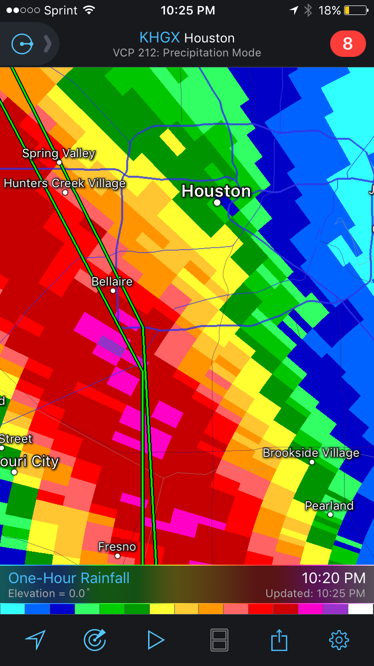
ULLETIN - EAS ACTIVATION REQUESTED
FLASH FLOOD WARNING
NATIONAL WEATHER SERVICE HOUSTON/GALVESTON TX
927 PM CDT SAT AUG 26 2017
...FLASH FLOOD EMERGENCY FOR WEST CENTRAL HARRIS, EASTERN FORT BEND AND
NORTHERN BRAZORIA COUNTIES...
THE NATIONAL WEATHER SERVICE IN LEAGUE CITY HAS ISSUED A
* FLASH FLOOD WARNING FOR...
EAST CENTRAL FORT BEND COUNTY IN SOUTHEASTERN TEXAS...
NORTHERN BRAZORIA COUNTY IN SOUTHEASTERN TEXAS...
CENTRAL HARRIS COUNTY IN SOUTHEASTERN TEXAS...
* UNTIL 1215 AM CDT.
* AT 921 PM CDT, DOPPLER RADAR INDICATED HEAVY RAIN ACROSS THE
WARNED AREA. 4 TO 8 INCHES OF RAIN HAVE FALLEN. RAINFALL RATES OF
3 TO 4 INCHES PER HOUR ARE OCCURING WITH THIS VERY SLOW MOVING
LINE OF STORMS. FLASH FLOODING IS ALREADY OCCURRING. WATER RESCUES
ARE ONGOING.
THIS IS A FLASH FLOOD EMERGENCY FOR WEST CENTRAL HARRIS COUNTY
EASTERN FORT BEND AND NORTHERN BRAZORIA COUNTIES. THIS IS A
PARTICULARLY DANGEROUS SITUATION. SEEK HIGHER GROUND NOW!
And rainfall upstream from both reservoirs is shown as between 6.8 and 9.7 inches so far with one gage on both tributaries registering between 9 and 10 inches!
Scary as heck!
We are on generator again. Thank you, Lord, for the generator!!
The rain and tornados are the scary part.
Stay safe!
Disclaimer: Opinions posted on Free Republic are those of the individual posters and do not necessarily represent the opinion of Free Republic or its management. All materials posted herein are protected by copyright law and the exemption for fair use of copyrighted works.
