
Posted on 05/31/2019 11:15:01 AM PDT by Twotone
For all the time spent and attention monopolized in our national discussion of global warming and climate change, attention which to date has produced practically nothing in terms of concrete and substantial solutions to a demonstrable and present threat, there are two foreseeable, or more to the point practically inevitable, environmental events which directly threaten American life as we know it.
Neither has a thing to do with global warming.
The more dire, and more unavoidable, of the two is the eventual volcanic eruption of the massive caldera at Yellowstone National Park, which will ultimately threaten the survival of civilization. A supervolcanic eruption at Yellowstone might or might not be an extinction-level event, but it would certainly make much of North America uninhabitable for a protracted period of time, greatly disrupt agriculture and the global food supply and sharply curtail Earth’s ability to support human and other animal life for long enough to permanently change our global ecosystem.
But a Yellowstone event is perhaps thousands, or tens of thousands, of years away, and it carries effects of such a magnitude that we are utterly powerless to mitigate, much less prevent.
The other threat is far more immediate, and eminently more preventable, and while it doesn’t carry the gravity of a Yellowstone eruption its potential effect on the global economy can’t be understated.
Namely, that the Mississippi River, the world’s most economically significant watershed, is coming to the end of its lease and considering relocation.
Old Man River is a frightening and uncooperative beast in the best of times. It’s an alluvial river, meaning the Mississippi’s bed isn’t solid rock like, for example, the Colorado. At its bottom the Mississippi flows on top of sand and mud...
(Excerpt) Read more at spectator.org ...
Bookmark
That’s quite an engineering task trying to make the mighty Mississippi behave !
Usually these ‘sky is falling’ pieces are liberal hysteria - but this one looks real...
Once the Wall is built Trump should take a look at it.
Wow, good read. The things we don’t know of the past.
I never knew Einstein’s son worked with ORCS!
As to our primary national concerns, may I instead posit our national debt and illimmigration/multiculturalism.
“a demonstrable and present threat,”
Please provide evidence obtained using the Scientific Method.
I did several news reports on this very subject, Mississippi shifting, more than thirty years ago when I worked for WWL-TV
Things really do move slow in the South.
The flooding of the country with foreigners, many of them illegal aliens, is the primary threat to the country’s survival.
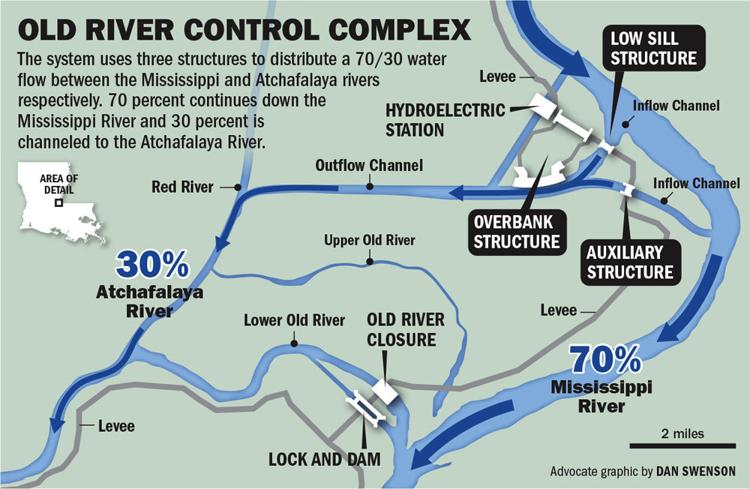
Actually, it is the people who write these alarmist articles. They NEVER bother to study the whole design of the totality of the Mississippi control program. The ORCS, Morganza Spillway, and EAST Atchafalaya Floodway only constitute ONE HALF of the capacity of the system. These use fine-tunable structures. The WEST half of the floodway consists of a low-sill levee, which is specifically designed to fail (and if it doesn't, will be blown up) to relieve any danger to the EAST half of the Floodway. The presence of that WEST Floodway is why the towns of Simmesport, Melville, etc. are totally surrounded by levees. Folks who have built homes and businesses outside those levees WILL have them washed away......but the control also WILL be protected.
https://www.nps.gov/vick/learn/nature/river-course-changes.htm
The Mississippi River has changed course to the Gulf every thousand years or so
for about the last 10,000 years. Gravity finds a shorter, steeper path to the Gulf
when sediments deposited by the river make the old path higher and flatter. It’s
ready to change course again. It wants to take a short cut at the Old River
Control Complex down the Atchafalaya River to the Gulf at Morgan City, Louisiana.
It’s 193 miles shorter and steeper and faster than going by New Orleans.
Gravity makes water flow downhill. The higher the hill, the greater the “head”
or force driving the flow. Floods on the Mississippi raise the water level
inside the levees and increase this force. Floods are becoming more frequent,
longer, and higher — even though average annual rainfall in the Mississippi
drainage basin has been almost flat since 1940.
It has flooded every other year on average since 1972 vs. once every six and
a half years 1940-72. It has flooded eight of the last ten years at Natchez.
There have been two hundred-year floods within five years (2011 and 2016).
The odds are over a thousand-to-one against this. The average level or
stage of the river has risen ten feet at Natchez since 1972.
https://biggerpieforum.org/environment/growing-concern-mississippi-river-course-change/
Interesting! “Planning is great until bullets fly” - Eisenhower. If an earthquake changes the course...
“Planning is great until bullets fly” - Eisenhower.””
Evvyboddy got a fight plan ‘til he get hit in da mouf”. Mike Tyson
I was born and raised in north Pointe Coupee Parish, and grew up watching all these structures being built and operated over the years. VERY few people in the general public have a clue to the complexity of planning that has gone into the design of this complex system....and that tendency has only increased with the increase in computer modelling capabiliy. Originally, they did it with scale models (involving several HUNDRED acres to build a model with the necessary scale of depths and heights). Saw a Youtube video about that once upon a time....fascinating.
Disclaimer: Opinions posted on Free Republic are those of the individual posters and do not necessarily represent the opinion of Free Republic or its management. All materials posted herein are protected by copyright law and the exemption for fair use of copyrighted works.