Free Republic
Browse · Search
General/Chat
Topics · Post Article

To: decimon
The Yellowstone HotSpot Trail:

Photobucket
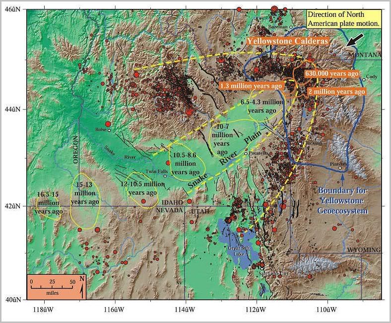
Figure 1. Path of the Yellowstone hotspot. Yellow and orange ovals show volcanic centers where the hotspot produced one or more caldera eruptions- essentially "ancient Yellowstones"- during the time periods indicated. As North America drifted southwest over the hotspot, the volcanism progressed northeast, beginning in northern Nevada and southeast Oregon 16.5 million years ago and reaching Yellowstone National Park 2 million years ago. A bow-wave or parabola-shaped zone of mountains (browns and tans) and earthquakes (red dots) surrounds the low elevations (greens) of the seismically quiet Snake River Plain. The greater Yellowstone "geoecosystem" is outlined in blue. Faults are in black.

http://volcanoes.usgs.gov/yvo/figures/fig1.html

5 posted on 04/03/2009 1:37:22 PM PDT by ETL (ALL the Obama-commie connections at my FR Home page: http://www.freerepublic.com/~etl/)
[ Post Reply | Private Reply | To 1 | View Replies ]


To: ETL

Ah, you beat me to it.


14 posted on 04/03/2009 6:29:47 PM PDT by patton (If Hawai'i seccedes, is Barack Obama still an illegal alien?)
[ Post Reply | Private Reply | To 5 | View Replies ]

Free Republic
Browse · Search
General/Chat
Topics · Post Article


FreeRepublic, LLC, PO BOX 9771, FRESNO, CA 93794
FreeRepublic.com is powered by software copyright 2000-2008 John Robinson