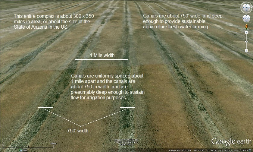
Look at Google Earth 18 degrees 10’ south and 18 degrees 30’ east, from an elevation of 45 miles, and you will see these canals.
any hint of when they think the system was either created or last in use???
A most interesting web site,must investigate further
Pretty wild. I’m surprised this formation isn’t more well known.
Bfl
http://earthobservatory.nasa.gov/IOTD/view.php?id=51190
Search for “linear dunes”. Nothing exciting.
Don’t see how the technology existed to make that many parallel lines that perfectly straight for that long of a distance.
Having spent a bit of time going over the area I’m not convinced they are in any way a man made feature. They look more like a combination of structural trends, and/or dune (aeolian or shallow water) features modified and enhanced by overland flow during heavy rainfalls.
That’s my geological $0.02 worth
Understanding linear dune chronologies
http://sajg.geoscienceworld.org/content/110/4/535.abstract
“
Abstract
The degraded linear dunefield of north west Ngamiland, Botswana occurs in a seismically active area, lying to the northwest of the Okavango graben, widely considered to be the tail end of the East African Rift system. To assess the effects of neotectonism on the dunes, an area was selected for examination close to the Gumare fault, which bounds the graben on the northwest side. Digital SRTM data were converted to light shaded representation of the topography. It was found that dune forms only occur along the margin of the rift and on both sides of incising valleys, graded to the graben floor. A selection of long profiles showed dune crests standing some 25 m above the straats at the edge of the rift. The relative relief pinches out away from the fault, towards interfluves that do not depict dune morphology. Landsat satellite imagery shows linear features continuous across the flat interfluves, inviting the incorrect inference from the vegetation that the linear dune forms occur there. A model is proposed that an original linear dune field formed under arid conditions, was entirely flattened under wetter conditions, crest material being washed into the straats, thus obliterating the original dune morphology. Upon rifting and stream incision, these forms are being replicated, an example of equifinality. Replication is suggested to be by the action of infiltrating water, controlled by the groundwater gradients. These observations suggest that the active dunefield significantly predates the tectonic processes. With the additional time required for degradation and replication it would suggest that the dunes are of considerable antiquity. It has already been recognised that the dunefield has a complex history of construction and destruction, to which must now be added a process of base level-controlled replication.”