Posted on 01/03/2015 4:10:32 PM PST by Fred Nerks
From my Free Web Book 'AncientCanalBuilders.com'
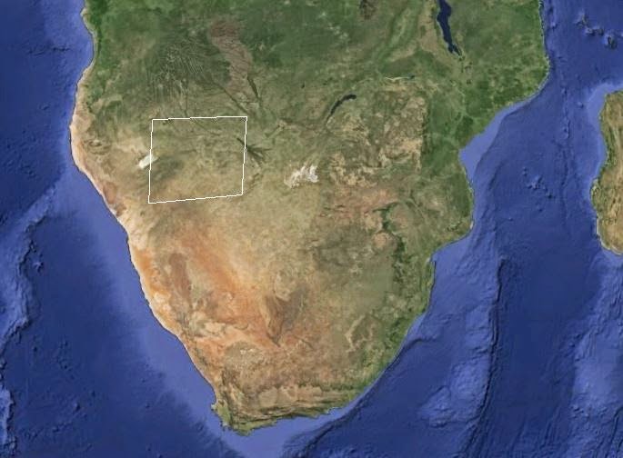
The largest wide-array man made (or at least non natural) structure in the world is in fact an ancient terra formed systems of agricultural-aquaculture canals in Northwestern Botswana and Northeastern Namibia, north of the Kalahari Desert in Southern Africa. Obviously quite ancient, the canal systems no longer provide free flowing water throughout its 105,000 mile array, but many sections show obvious intention to provide cross sectional irrigation.
These canals are too evenly spaced over too large an area to be any kind of natural formation. Based on entry and exit points, it is readily apparent this system is a very large, controlled agronomy array and/or aquaculture system. Its age is defined by the overgrown nature of the canals, as well as some areas that are covered over with drift and sand erosion.
The entire complex covers an area about equal in size to the State of Arizona in the USA. The canals are an integrated system of apparent irrigation and agricultural (and probably aquaculture) design. The system is about 350 miles in width and about 300 miles in depth. (For the remnants still visible.) This system represents roughly 67 MILLION acres of sustainable agriculture. Given the sophistication of design, it is entirely plausible to assume an above average yield, i.e. feeding well over 90 persons per acre on an annual basis. The system may or may not have provided a sustainable aquaculture (marine farming) environment. I have no reason to suspect that it did not.
Given the size and scope of this complex, (canals are about 1 mile apart on average) and collectively are roughly 350 X 300 miles in a rough rectangular format. (At least the observable parts) There could be, and probably is, much more to this complex than what is visible to the naked eye. Right now, we can identify ancient cultivation of roughly 105,000 square miles.
One square mile = 27,878,400 square feet, or 640 acres, so the entire complex had a sustained producing land mass of (640 acres x 105,000 square miles) or > 67,200,000 acres. (That is 67 MILLION acres)
One linear mile of canal had (750' width x + >12' depth x 5,280') = 47,520,000 cubic ft of water per linear mile.
Entire canal length (105,000 miles x 47.5 million cubic ft per mile) = 5,000,000,000,000 (That's 5 TRILLION) cubic feet of water in the canals. It would be an incredible waste of time and effort to irrigate >105,000 square miles of sustainable agriculture land, and not use the 5 trillion cubic feet of water circulating in the canals for aquaculture farming. I don't think the builders were that stupid.
Different estimates of the numbers of people this sustainable system would supply varies widely, though it is generally accepted that a system like this, if properly managed would provide a complete annual diet for somewhere between 60 to 120 people per acre. Which means this system was in fact providing food for an average of about 5 Billion people.
This array is in fact the largest non natural artifact on the Planet. It can be clearly viewed unaided from the International Space Station at roughly 230 miles up, which cannot be said for any other non natural feature on Earth.
I would suggest that depth of canal(s) must have been significant to compensate for general slight variations in elevation. There seems to be an average elevation variation of about 60', sometime more, and sometimes less.
Your comments are welcome, or you can contact me here:
johnmjensenjr@gmail.com 321-614-5040
First brought to my attention by Gary Schoening Here is his original Vimeo post: http://vimeo.com/64351951
That, again is the result of wind action on sand.
Whoa. You can feed five billion people n an irrigated/aquacul;ture area the size f the state of Arizona?
Wha..?
SWhere was their water source?
When?
WHO?
And what happened to them?
And where are their descendants now?
So many questions.
...something stinks about the whole thing...photo was taken from satellite..?
It didn’t work out due to climate change which drove the surface water deep underground. There is an underground ocean of freshwater beneath Africa that was found recently.
Having said that, I’m thinking this a naturally occurring phenomenon, not a mandmade one.
Quite simply the writer is a typical charlatan. He makes declarations of facts that just aren’t true like claiming nature doesn’t make straight lines.
Personally I suspect that they are prehistoric Dunes from an arid period in Africa’s distant past. For instance, during the last ice age the Sahara was much greener and the deserts of Africa were further south.
Too many major problems like where did these billions of people go without leaving any trace by their “canals”.
BS meter is pinging.
10,000 years old+, feeding 5 billion people?
i think not.
Ancient aliens race cultivated the earth millions of years ago and used dinosaurs to pull huge titanium plows. Man I thought everyone knew this...
Giants, Mound Builders, “There went up a mist from the earth, and watered the whole face of the ground.” Gen. 2:6
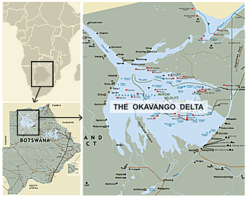
The region is right on the edge of the Okavango Delta. Why don't you download Google Earth, it's free, and have a look for yourself? You might even enjoy a trip through the Vernuekpan Basin. It's not far away.
I’ve got google earth and the guy is still a charlatan.
He must be the same charlatan who created the endless number of canal images throughout South America and for good measure, doodled all over the dried lakebed named Vernuekpan. He’s been awfully busy.
Look at Google Earth 18 degrees 10’ south and 18 degrees 30’ east, from an elevation of 45 miles, and you will see these canals.

Seriously, this is very cool.
any hint of when they think the system was either created or last in use???
A most interesting web site,must investigate further
There are terraces all over the Andes. It seems like there must have been a much larger population to require all those terraces, or people have lived there for a very, very long time. Do you happen to know if salts build up in terraces over time, making them eventually unviable?

Let me say...I have no idea who or what created this phenomenon, but not knowing doesn't mean it's not there.
The Okavango Delta is seasonal. These so called canals look like rock straitions from a receding glaciar, on a particularly grand scale.
Maras Salt Terrace, Peru
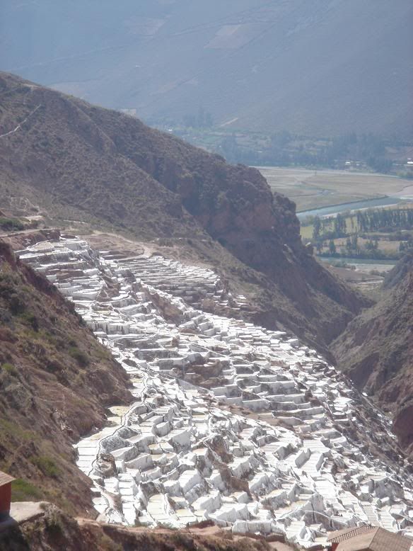
Salt would hardly have been an issue in the Okavango Delta, it's still flowing with bounteous fresh water today.
Disclaimer: Opinions posted on Free Republic are those of the individual posters and do not necessarily represent the opinion of Free Republic or its management. All materials posted herein are protected by copyright law and the exemption for fair use of copyrighted works.