MISSION CONTROL STATUS REPORT
Posted: March 18, 2004
A major ingredient in small mineral spheres analyzed by NASA's Mars Exploration Rover Opportunity furthers understanding of past water at Opportunity's landing site and points to a way of determining whether the vast plains surrounding the site also have a wet history.
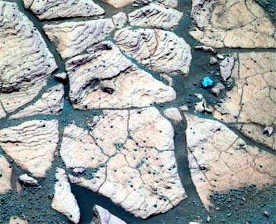 This false-color composite image, taken at a region of the rock outcrop dubbed "Shoemaker's Patio" shows finely layered sediments, which have been accentuated by erosion. The sphere-like grains or "blueberries" distributed throughout the outcrop can be seen lining up with individual layers. Credit: NASA/JPL/Cornell Download a larger image here |
Individual spherules are too small to analyze with the composition-reading tools on the rover. In the past week, those tools were used to examine a group of berries that had accumulated close together in a slight depression atop a rock called "Berry Bowl." The rover's Moessbauer spectrometer, which identifies iron-bearing minerals, found a big difference between the batch of spherules and a "berry-free" area of the underlying rock.
"This is the fingerprint of hematite, so we conclude that the major iron-bearing mineral in the berries is hematite," said Daniel Rodionov, a rover science team collaborator from the University of Mainz, Germany. On Earth, hematite with the crystalline grain size indicated in the spherules usually forms in a wet environment.
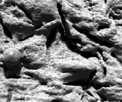 This microscopic image, taken at the outcrop region dubbed "El Capitan," reveals millimeter-scale (.04 inch-scale) layers in the lower portion. This same layering is hinted at by the fine notches that run horizontally across the sphere-like grain or "blueberry" in the center left. The thin layers do not appear to deform around the blueberry, indicating that these geologic features are concretions and not impact spherules or ejected volcanic material called lapilli. Credit: NASA/JPL/Cornell/USGS Download a larger image here |
"The question is whether this will be part of a still larger story," Knoll said at a press briefing today at NASA's Jet Propulsion Laboratory, Pasadena, Calif. Spherules below the outcrop in the crater apparently weathered out of the outcrop, but Opportunity has also observed plentiful spherules and concentrations of hematite above the outcrop, perhaps weathered out of a higher layer of once-wet deposits. The surrounding plains bear exposed hematite identified from orbit in an area the size of Oklahoma -- the main reason this Meridiani Planum region of Mars was selected as Opportunity's landing site.
"Perhaps the whole floor of Meridiani Planum has a residual layer of blueberries," Knoll suggested. "If that's true, one might guess that a much larger volume of outcrop once existed and was stripped away by erosion through time."
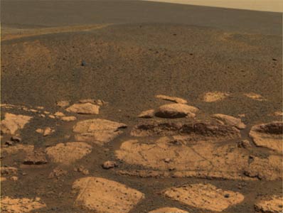 This approximate true-color image suggests that the plains beyond the small crater where Opportunity now sits are littered with the same dark grey material found inside the crater in the form of spherules or "blueberries." Credit: NASA/JPL/Cornell Download a larger image here |
Halfway around Mars, NASA's other Mars Exploration Rover, Spirit, has been exploring the rim of the crater nicknamed "Bonneville," which it reached last week. A new color panorama shows "a spectacular view of drift materials on the floor" and other features, said Dr. John Grant, science team member from the National Air and Space Museum in Washington. Controllers used Spirit's wheels to scuff away the crusted surface of a wind drift on the rim for comparison with drift material inside the crater.
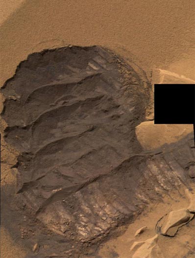 This mosaic image from Spirit shows the trench or "scuff" mark in the Gusev Crater location dubbed "Serpent." The trench is approximately 30-35 centimeters (12-14 inches) across and 40-45 centimeters (16-18 inches) long from top to bottom. Credit: NASA/JPL/Cornell Download a larger image here |
Controllers have decided not to send Spirit into Bonneville crater. "We didn't see anything compelling enough to take the risk to go down in there," said JPL's Dr. Mark Adler, mission manager. Instead, after a few more days exploring the rim, Spirit will head toward hills to the east informally named "Columbia Hills," which might have exposures of layers from below or above the region's current surface.
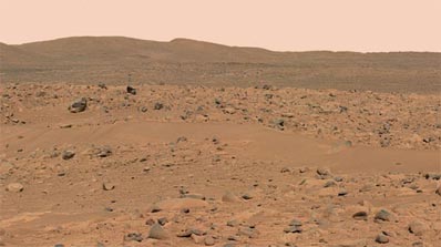 This image from Spirit shows the rover's destination toward the hills nicknamed the "Columbia Hills." Credit: NASA/JPL/Cornell Download a larger image here |
JPL, a division of the California Institute of Technology in Pasadena, manages the Mars Exploration Rover project for NASA's Office of Space Science, Washington, D.C.
