Posted on 12/17/2008 7:42:08 AM PST by BGHater
I’d be standing under that, undoubtedly that’s been engineered to let Bernanke drop megadollars.
Fail.
Bump for Sarah!
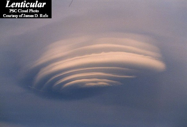
This being the second instance in a couple of weeks, sort of begs the question of how unusual this actually might be. But, I’ve been a weather geek for most of my life, and do not recall ever seeing this sort of thing until the last several years. I’ve had a few meteorology courses, and to my mind, the two or three cloud formations present in the photo are not possible, side by side, naturally, let alone within a near perfect circle.
A jet didn’t do this. Jets have been around for over half a century. It’s got to be some sort of military tech. That weatherman out in Colorado might not be the nut he’s been made out to be.
"In Before The Journey Reference"
His website is down. Must be looking for work again.
Im looking through a hole in the sky
Im seeing nowhere through the eyes of a lie
Im getting closer to the end of the line
Im living easy where the sun doesnt shine....
Maybe Art Bell will take pity and give him a gig. You’d think the notoriety would be good for money somewhere.
It also looks like something headed off to the right, with the outer edges of the cirlce following, somewhat, in the direction of what left it.
Updraft.
lolz
Most who look at this, and question the official cause if any is given, are probably thinking along the lines of that Bearden guy and his “scalar magnetics,” like the previously mentioned weatherman, Scott Stevens. There’s a whole internet “industry” built up around this sort of thing. Photos such as this feed the speculation. It’s not naturally occurring, and a jet didn’t do it, imho. Beyond that, you’re heading into territory that has been thoroughly tinfoiled.

Al Gore farted? Tax him.
Yep - lenticulars are pretty unusual in most areas, but not around here. We get ‘em regularly above the mountains. The upper level winds can do some pretty spectacular stuff with them.
A jet may have disturbed the area to cause some sinking of air but the most likely cause is just some cooler air above the cloud deck descended through it. The air warms as it falls and that dries the cloud portin out. It’s a reverse thermal.
I saw these things a lot in Illinois especially after an Alberta Clipper descended over the plains. Cold dry stable air, cloud cover above the inversion and then mixing at the inversion level. The coolest one we saw actually formed right before our eyes as we were outside doing a rawinsonde run.
The cloud formations within the near perfect circle don’t indicate a thermal inversion to me. Observers reported that the cloudcover was fairly low altitude, too.
Disclaimer: Opinions posted on Free Republic are those of the individual posters and do not necessarily represent the opinion of Free Republic or its management. All materials posted herein are protected by copyright law and the exemption for fair use of copyrighted works.