Free Republic
Browse · Search
General/Chat
Topics · Post Article


1 posted on 09/17/2009 2:25:03 PM PDT by JoeProBono
[ Post Reply | Private Reply | View Replies ]


To: JoeProBono

Talk about linking two things that can’t be linked. What a joke of a headline.


2 posted on 09/17/2009 2:27:26 PM PDT by Psycho_Bunny (ALSO SPRACH ZEROTHUSTRA)
[ Post Reply | Private Reply | To 1 | View Replies ]

To: SunkenCiv

ping


3 posted on 09/17/2009 2:27:45 PM PDT by Lurker (The avalanche has begun. The pebbles no longer have a vote.)
[ Post Reply | Private Reply | To 1 | View Replies ]

To: JoeProBono

So, they built a beautiful and elaborate system of navigation, and did pretty much nothing else? To get from one clutch of stone and stick huts to the next?

Thank goodness for the Roman and Norse invasions!


5 posted on 09/17/2009 2:30:26 PM PDT by OldSpice
[ Post Reply | Private Reply | To 1 | View Replies ]

To: JoeProBono
LONDON: In a new research, a scientist has found that prehistoric man navigated his way across England using a crude version of a satellite navigation system, which was based on stone circle markers. According to a report in the Telegraph, the research, by historian and writer Tom Brooks, shows that Britain’s Stone Age ancestors were “sophisticated engineers” and far from a barbaric race.

The only problem was that prehistoric man had a tough getting the "GPS log" to stay in orbit....


6 posted on 09/17/2009 2:32:41 PM PDT by Alex Murphy (...We never faced anything like this...we only fought humans.)
[ Post Reply | Private Reply | To 1 | View Replies ]

To: JoeProBono

Sat-Nav (GPS) is man’s crude version of God’s wonders.....”The earth, the moon and the stars”.....in sync...
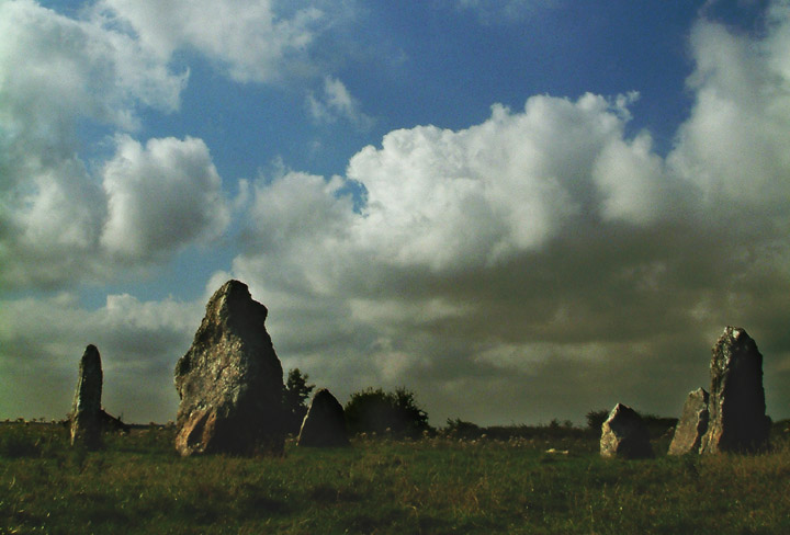

7 posted on 09/17/2009 2:34:09 PM PDT by Sacajaweau
[ Post Reply | Private Reply | To 1 | View Replies ]

To: JoeProBono

9 posted on 09/17/2009 2:50:34 PM PDT by ironwill (III - Molon Labe)
[ Post Reply | Private Reply | To 1 | View Replies ]

To: JoeProBono
Centuries later the stones were replaced with metallic plates that further increased the precision of navigation...


11 posted on 09/17/2009 2:54:27 PM PDT by Joe 6-pack (Que me amat, amet et canem meum)
[ Post Reply | Private Reply | To 1 | View Replies ]

Stone Age satnav:
Did ancient man use 5,000-year-old travel chart to navigate across Britain
The Daily Mail | 15 Sep 2009 | David Derbyshire
Posted on 09/15/2009 1:13:16 PM PDT by BGHater
http://www.freerepublic.com/focus/chat/2340382/posts


15 posted on 09/17/2009 3:06:23 PM PDT by SunkenCiv (https://secure.freerepublic.com/donate/__Since Jan 3, 2004__Profile updated Monday, January 12, 2009)
[ Post Reply | Private Reply | To 1 | View Replies ]

To: JoeProBono
Brooks found that they all lie on a vast geometric grid made up of isosceles triangles.

Many are 100 miles or more away,

Each triangle has two sides of the same length and point to the next settlement.

Thus, anyone standing on the site of Stonehenge in Wiltshire could have navigated their way to Lanyon Quoit in Cornwall without a map.

Wot an idjit!

So, I'm here at the first stone circle thingy, ow the 'ell do I know were the next circle thingy is?

Hunnert miles you say? Mebbe more? Ow, that's four, five, mebbe six days on shank's mare, never mind no food with them bluidy scot MacDonalds kine rustlers way up north.

And so far as finding the Welsh, well the onion smell kinda of leads you to them, dunnit.

Bluidy historian, couldn't find a footpath without a swift kick... ah well, an idjit I say.

16 posted on 09/17/2009 3:06:53 PM PDT by Covenantor ("Men are ruled...by liars who refuse them news, and by fools who cannot govern." Chesterton)
[ Post Reply | Private Reply | To 1 | View Replies ]

Free Republic
Browse · Search
General/Chat
Topics · Post Article


FreeRepublic, LLC, PO BOX 9771, FRESNO, CA 93794
FreeRepublic.com is powered by software copyright 2000-2008 John Robinson