Posted on 08/30/2012 9:25:21 AM PDT by Blueflag
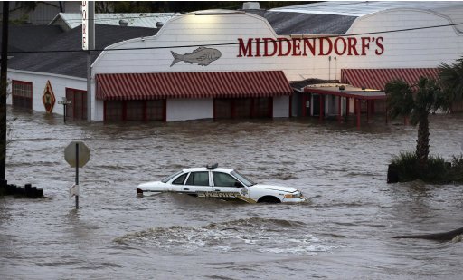
IF you go to the Drudgereport you'll see a pic of a flooded restaurant in Akers, LA. This seafood joint is on the North shore of Lake Maurepas, just west of Lake Pontchartrain -- NW of New Orleans. It sits REAL close to the water's edge below Interstate 55 which is elevated probably 25 feet (guessing) above the ground below. I am postulating this shows what the storm surge there has done, as opposed to rainfall.
This link shold take you to a street view where you can just about duplicate the pic on the Drudgereport.
http://maps.google.com/maps?q=middendorf's+seafood-manchac+la&ll=30.289514,-90.402589&spn=0.003029,0.00486&fb=1&gl=us&hq=middendorf's+seafood-manchac+la&cid=0,0,6392791585389205583&t=h&z=18&layer=c&cbll=30.289711,-90.402629&panoid=xPsDGbpc-o6PR-5IA3YkRA&cbp=12,93.54,,0,-5.74
Shift the view to the east and you can see Middendorf's two buildings, sans flooding and the stranded sheriff's car.
I only post this 'cuz I have been RIGHT THERE several times.
Prayers for our fellow FReepers and others in the area.
(Excerpt) Read more at drudgereport.com ...
This link shold take you to a street view where you can just about duplicate the pic on the Drudgereport.
http://maps.google.com/maps?q=middendorf's+seafood-manchac+la&ll=30.289514,-90.402589&spn=0.003029,0.00486&fb=1&gl=us&hq=middendorf's+seafood-manchac+la&cid=0,0,6392791585389205583&t=h&z=18&layer=c&cbll=30.289711,-90.402629&panoid=xPsDGbpc-o6PR-5IA3YkRA&cbp=12,93.54,,0,-5.74
Shift the view to the east and you can see Middendorf's two buildings, sans flooding and the stranded sheriff's car.
I only post this 'cuz I have been RIGHT THERE several times.
Prayers for our fellow FReepers and others in the area.
Here’s another. Just local interest for people who live(d) there or have been there.
After seeing some of the damage this category 1 storm has done, I’m very happy I left New Orleans.
I know they lucked out on this storm, and some of the surrounding areas did not, but every tropical event is going to be a hold your breath situation for New orleans.
If the city ever gets hit by the wrong storm going in the right direction, it is going to be erased by the Gulf. If a cat 4 or 5 ever hovered in the gulf for a day or 2 south of the city, it’s over.
I still live in the south, but I’m about 100 ft above sea level now instead of 10 ft below. I think New Orleans has exactly as much time as Mother Nature gives her, and Mother Nature is a ruthless :O
Here’s the Drudgereport pic, strictly for comparison —
I would say a ‘reporter’ safely drove north from New Orleans, pulled off on the shoulder on the northbound side of 55 and snapped this pic.
Just spoke to friends in Pensacola and Mobile who reported VASTLY improved weather for them.
You would think with the days upon days of hurricane and flood warnings, that all those folks would have evacuated, but for some reason they failed to act, just like all those folks in New Orleans during Katrina.
You would think that the folks on the North Shore would have learned a lesson from the New Orleans people.
When I lived in Louisiana, we vacationed in Gulf Shores one year that Hurricane Florence came through.
We had left the TV off most of the week, and noticed the storm clouds. So we turned the TV on and realized we were under evacuation orders and had been for over a day. We threw everything in the car and headed out.
Water was already covering the road to get off the island, making it very hard to see the road. But we managed to get off the island and then to I-10 and headed home.
We got close to Lake Ponchatrain and traffic slowed to a crawl with all of the people coming out of New Orleans. At that point Interstate 10 is built up high out of the swamps. You're level with the tree tops and they were swaying big time. So we're crawling along 5 miles an hour on the interstate surrounded by water watching the trees whip back and forth.
Once we got past Lake Ponchatrain everything was fine. We headed on into Baton Rouge and stopped and had dinner at Ralph and Kacoo's.
He was a conductor on the Galveston-Houston Inner Urban Railway and was trying to evacuate some of the women and children from the island when the surge caught them on the causeway.
Nooooooo!!! Middendorf’s had some of the best fried catfish available anywhere! I always tried to time my travel up or down I-55 to be able to have lunch or dinner at the place.
They are a Louisiana institution. I’m sure the restaurant will be rebuilt/renovated and reopened within a few months. Check it out if you’re ever motoring along on I-55 on the north side of Ponchartrain.
Yeah I know :-(
Two buildings, no waiting! sorta.
But you are right, once the water recedes, they’ll be open by October.
I know something like that happened in the 1900 hurricane, I didn't realize there was another one that did the same in 1915.
I got the same picture on MSN.com page when going to my hotmail.
Drudge? He’s dead to me...sorry no clicks for the homo.
The 1900 Hurricane flooded the entire island, killing 10,000+. In response, the city raised the level of the entire island almost 20 feet, but people were still worried when this storm came in, so they tried to evacuate as many women and children as possible.
Not over until the fat lady sings. She has not even cleared her throat in New Orleans yet. All that water that has fallen north of New Orleans and is still falling, will eventually be putting pressure on the New Orleans levies. This is Katrina in slow motion. Deja vu, all over again.
Ah, that is very true.
My friend is there now thinking of come here to FL because he has been without power for some time now.
You know, the thing about Katrina was that it essentially missed New Orleans entirely.
If I am not mistaken, the highest recorded winds were around 85 near New Orleans East and the eastern edge of the lake.
So they experienced, for all pratical purposes, a category 1 at the time.
I think what made it so dangerous was the amount of water Katrina pushed into the the lake and then as it moved north and the winds switched to southerly, all that water was blown back against the levee system and it popped.
That scenario could easily be achieved again by a small storm, and God Help them if a major storm actually passes directly over them on the SE, to N, to NW track they then can sometimes take.
The worst case scenario is for the storm to hit to the East, because the rotation would push the water from Lake Ponchatrain into the city. It would have been better off taking a direct hit.
I was on Galveston Island when Hurricane Alicia came through heading for Houston, I think this was 1985 or so, earlier across the causeway the water was far below the roadway, I was one of the very few (or dumb enough) that stayed almost too late before crossing the causeway, with 100 mph winds the waves were swept up and over the causeway heavy enough I was driving over fish, true story.
And on the trip back to Houston I could nearly have kept the truck in neutral with the winds behind me pushing me at over 50mph.
I still have that old 1974 Chevy Pu all the way up here in Alaska.
I think I drove far enough to get away from hurricanes....
Yep, but also, if say a cat 5 were to hover SE of the river for a day or two and push water into the lake that entire time, and then move up east of the city such that the wind blew from north to south, that would be a doomsday type scenario for the city.
Katrina essentially did that, however im not sure how long it remained in the gulf S or SE of of the river outlet.
That is when I saw it, on saturday afternoon. I admit I wasn’t paying a damn bit of attention to it, then I happned to click of Drudgereport at about 4:00 pm that day, saw where it was and what it was, and I got the FLIP OUT OF DODGE with my dogs, my best friend and my mom as fast ask I could, which was at midnight that evening.
Had I left even 4 hours later, I would not have been able to get two hotel rooms that allowed pets, and I would have been stuck in contra flow traffic for God knows how long.
We were extremely fortunate, God helped us, that’s all I can say.
The problem they have to deal with eventually is a flooded Lake Pontchartrain. And they have just started releasing water from a dam up in Mississippi that empties into Lake Pontchartrain. That Lake will rise to near record levels. All the rivers north of that lake are over flood stage. And the Mississippi will be filling up with Isaac water falling up north. Basically a flooding Lake Pontchartrain is what flooded New Orleans last time. The Mississippi levies all held. Heck, if the Mississippi levies failed, New Orleans would have been wiped clean off the map.
Disclaimer: Opinions posted on Free Republic are those of the individual posters and do not necessarily represent the opinion of Free Republic or its management. All materials posted herein are protected by copyright law and the exemption for fair use of copyrighted works.