Free Republic
Browse · Search
General/Chat
Topics · Post Article

Skip to comments.

Hurricane MATTHEW Forecast Discussion (Category 5)
National Hurricane Center ^ | September 30, 2016

Posted on 09/30/2016 8:09:10 PM PDT by rdl6989

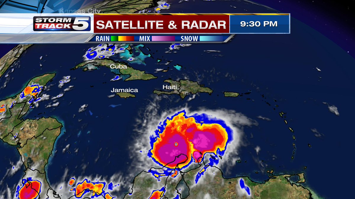
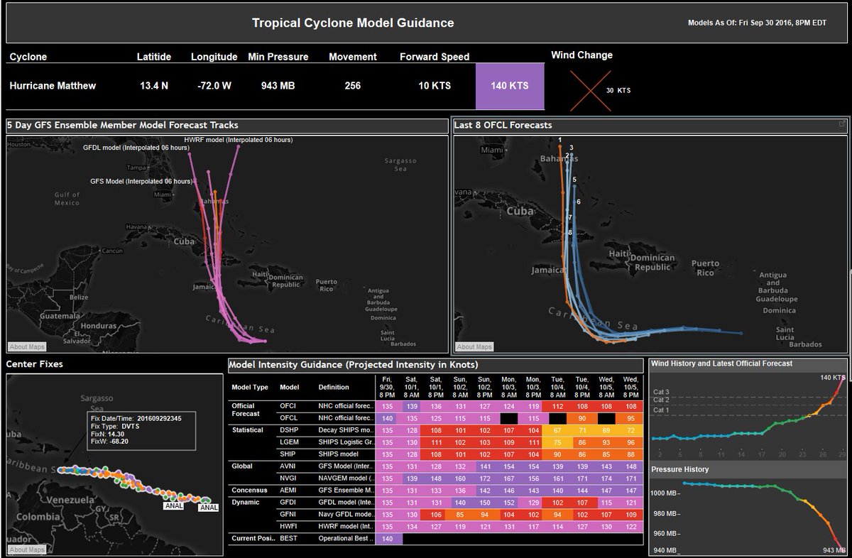
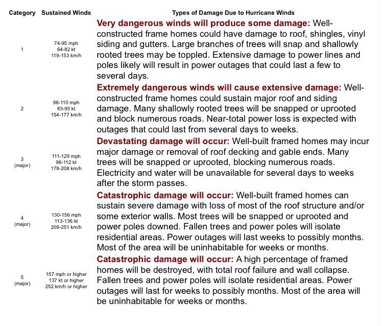
An Air Force reconnaissance plane recently measured a peak SFMR wind of 143 kt and then 138 kt during this mission's eye penetrations. Furthermore, the satellite presentation has improved considerably with a distinct eye surrounded by a ring of very deep convection. The raw objective T-numbers from UW-CIMSS have been above 7.0 since 2100 UTC. On this basis, the initial intensity has been increased to 140 kt, making Matthew a Category 5 on the Saffir-Simpson Hurricane Wind Scale. This is the first Category 5 hurricane in the Atlantic basin since Hurricane Felix in 2007.

(Excerpt) Read more at nhc.noaa.gov ...


TOPICS: Weather
KEYWORDS: cat5hurricane; hurricane; hurricanematthew; hurricanematthew2016; matthew; tropical; weather
Navigation: use the links below to view more comments.
first previous 1-2021-4041-6061-8081-100 next last
To: DocRock

That’s a mighty nasty Hurricane there!!


21 posted on 09/30/2016 9:50:42 PM PDT by caww
[ Post Reply | Private Reply | To 16 | View Replies]

To: Jack Hydrazine
Folks, you are looking at a category 5 hurricane!!! Winds are 160 mph now 'sustained'.... pressure of 941 mb....worst of the worst. .......


22 posted on 09/30/2016 10:05:31 PM PDT by caww
[ Post Reply | Private Reply | To 20 | View Replies]

To: NautiNurse; rodguy911

Uh oh...


23 posted on 09/30/2016 10:07:53 PM PDT by nutmeg (I am a proud Deplorable)
[ Post Reply | Private Reply | To 1 | View Replies]

To: DocRock

24 posted on 09/30/2016 10:11:01 PM PDT by caww
[ Post Reply | Private Reply | To 16 | View Replies]

To: nutmeg

The strongest hurricane in the Atlantic since Felix in 2007.

Evan Thompson, director of the National Meteorological Service, said the first effects of the storm may be felt as early as Saturday.....”We do consider it serious,” Thompson said. “We are all on high alert.”


25 posted on 09/30/2016 10:16:39 PM PDT by caww
[ Post Reply | Private Reply | To 23 | View Replies]

To: caww; NautiNurse
The strongest hurricane in the Atlantic since Felix in 2007.

Evan Thompson, director of the National Meteorological Service, said the first effects of the storm may be felt as early as Saturday.....”We do consider it serious,” Thompson said. “We are all on high alert.”

Wow, damn scary. I hope somehow it goes out to sea. This could impact ALL of us along the eastern seaboard. Including eastern Canada...

Paging NautiNurse!

26 posted on 09/30/2016 10:22:02 PM PDT by nutmeg (I am a proud Deplorable)
[ Post Reply | Private Reply | To 25 | View Replies]

To: caww
Mark Sudduth @hurricanetrack Says.....

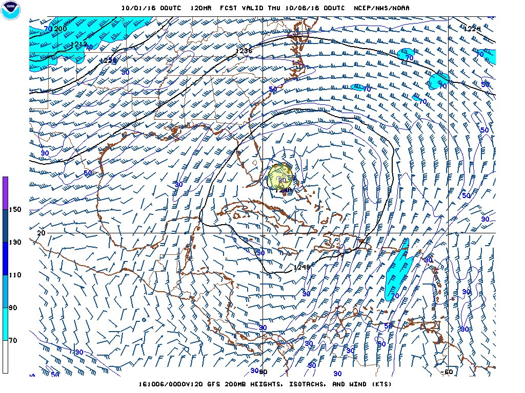
"Anytime you see the hurricane (yellowish area I added) reach the 200mb level, underneath a large anticylone, that's bad."


27 posted on 09/30/2016 10:25:38 PM PDT by caww
[ Post Reply | Private Reply | To 25 | View Replies]

To: nutmeg
Yes, looks pretty bad.....Jamaica right in it's path.....Cuba likely as well....one nasty beast!


28 posted on 09/30/2016 10:28:16 PM PDT by caww
[ Post Reply | Private Reply | To 26 | View Replies]

To: caww
Amazing storm....notice fro this model that Matthew will pass over even higher ocean heat content on its way north.


29 posted on 09/30/2016 10:31:34 PM PDT by caww
[ Post Reply | Private Reply | To 28 | View Replies]

To: nutmeg
Pictures sent from Andre Meehan in Kingston Jamaica. Getting ready for Matthew there...shelves are all but emptied out!


30 posted on 09/30/2016 10:34:59 PM PDT by caww
[ Post Reply | Private Reply | To 26 | View Replies]

To: TomGuy

That’s all we need is for Wilmington to get gob-smacked by a damn Cat 4.


31 posted on 09/30/2016 10:39:23 PM PDT by eyedigress ((Old storm chaser from the west))
[ Post Reply | Private Reply | To 11 | View Replies]

To: caww
'inside the eye' Hurricane Matthew when at CAT 4..... now at CAT 5.....Credit: Jessica Williams/NOAA


32 posted on 09/30/2016 10:43:48 PM PDT by caww
[ Post Reply | Private Reply | To 29 | View Replies]

To: eyedigress
Dr. Rick Knabb ‏@NHCDirector Dr. Rick Knabb Retweeted Michael o dell "We cannot rule out direct impacts from #Matthew for any location along U.S. East Coast."
33 posted on 09/30/2016 10:47:47 PM PDT by caww
[ Post Reply | Private Reply | To 31 | View Replies]

To: caww

I hate that. I do know folks in the “Low Country” that must change all plans and protect their boats.

The Front should push it out but there is a chance it isn’t enough. If this thing can carry though and ride up, not good.


34 posted on 09/30/2016 10:55:13 PM PDT by eyedigress ((Old storm chaser from the west))
[ Post Reply | Private Reply | To 33 | View Replies]

To: eyedigress
That’s all we need is for Wilmington to get gob-smacked by a damn Cat 4.

I'm not too far from Wilmington and I'm right on the water. While I would be happy to lose several large trees, I'd like to keep some of the house. If the tide swells over 12 feet I'd have a flooding problem - but I don't think it ever has. I'd bet the probability is low that it will hit NC. We generally seem to luck out. It could put a big dent in Florida though or just burn out at sea.

35 posted on 09/30/2016 10:57:15 PM PDT by Sunnyvale CA Eng.
[ Post Reply | Private Reply | To 31 | View Replies]

To: Sunnyvale CA Eng.

I hope your right. The coast of NC dares a hurricane to hit.

(BTW, I may post a pick of your port, it is massive)


36 posted on 09/30/2016 11:00:13 PM PDT by eyedigress ((Old storm chaser from the west))
[ Post Reply | Private Reply | To 35 | View Replies]

To: Sunnyvale CA Eng.

If your near the line I would start preps. At a minimum get boards for your windows. At worst you can use them again.

Book a hotel 100mi inland now. Pick a good one with 24 hours notice. Cancel if the storm goes out to open sea.


37 posted on 09/30/2016 11:08:21 PM PDT by eyedigress ((Old storm chaser from the west))
[ Post Reply | Private Reply | To 35 | View Replies]

To: caww
A category 5 hurricane Matthew means catastrophic damage will occur:


38 posted on 09/30/2016 11:12:21 PM PDT by caww
[ Post Reply | Private Reply | To 32 | View Replies]

My point being......

I have worked Hurricanes of Intensity and the coast is very dangerous. Book the rooms. You can always cancel.

Elana, Biloxi MS. 1985.


39 posted on 09/30/2016 11:14:40 PM PDT by eyedigress ((Old storm chaser from the west))
[ Post Reply | Private Reply | To 37 | View Replies]

To: caww

I have the original text of Katrina one day before the strike. Nobody cared.

One day later it was the Presidents fault.


40 posted on 09/30/2016 11:16:28 PM PDT by eyedigress ((Old storm chaser from the west))
[ Post Reply | Private Reply | To 38 | View Replies]


Navigation: use the links below to view more comments.
first previous 1-2021-4041-6061-8081-100 next last

Disclaimer: Opinions posted on Free Republic are those of the individual posters and do not necessarily represent the opinion of Free Republic or its management. All materials posted herein are protected by copyright law and the exemption for fair use of copyrighted works.

Free Republic
Browse · Search
General/Chat
Topics · Post Article

FreeRepublic, LLC, PO BOX 9771, FRESNO, CA 93794
FreeRepublic.com is powered by software copyright 2000-2008 John Robinson